Oberröppisch
|
Oberröppisch
City of Gera
Coordinates: 50 ° 50 ′ 5 ″ N , 12 ° 4 ′ 3 ″ E
|
|
|---|---|
| Height : | 250 m above sea level NN |
| Area : | 2.38 km² |
| Incorporation : | November 1, 1948 |
| Incorporated into: | Röppisch |
| Postal code : | 07549 |
| Area code : | 0365 |
|
The church
|
|
The formerly independent communities of Oberröppisch and Unterröppisch were merged on November 1, 1948 to form the new municipality of Röppisch . This was incorporated into the city of Gera on July 1, 1950. The Röppisch district of the city of Gera has 616 inhabitants (as of December 31, 2013).
geography
Oberröppisch is located on the left bank of the White Elster in the south of Gera in the direction of Weida on the federal road 92 .
history
On the Heersberg there was an early hill fort ; their remains were destroyed at the beginning of the 19th century when a quarry was built.
Belonging to the Reuss-Gera rulership , the place had 19 houses and 100 inhabitants in 1827. Several pieces of land belonged to the monastery of the Holy Cross in Saalburg as interest land . The border town to the Saxon lands was a branch of the city parish of Gera, but trained to Lusan .
In 1873, at the instigation of the landowners at the time, a water pipe was laid in the village, which was fed from a well cut into the sandstone 30 cubits deep.
On January 1, 1919, Oberröppisch was incorporated into the city of Gera, but was removed again on April 1, 1925. The new incorporation, now to Röppisch, took place on November 1, 1948. The reclassification to Gera took place on July 1, 1950.
Attractions
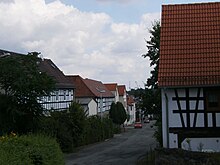
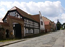
In addition to the church, the place has a number of listed courtyards.
politics
Röppisch with Oberröppisch and Unterröppisch has no district constitution, therefore no district council and no district mayor .
Development of the population
| year | 1827 | 1864 | 1910 | 1948 |
| Residents | 100 | 125 | 176 | 304 |
traffic
The federal highway 92 leads past the place. The stop there is served every hour by line 29 of the PRG Greiz , which connects the town with Gera and the district of Greiz. Line 13 of the GVB ensures school traffic.
The closest train station is Gera-Zwötzen or Wolfsgefärth . Until it was closed in 2000, Unterröppisch had its own “Gera-Röppisch” stop on the Leipzig – Probstzella railway line .
education
For the youngest there are six kindergartens or combined children's facilities with different concepts in Lusan .
Responsible primary schools with a common school district with free choice of school are the
- Erich Kästner Elementary School (Lusan) and the
- Wilhelm Busch Primary School (Lusan).
The closest regular school is the
- State regular school 4 , plus the
- IGS Integrated Comprehensive School .
Individual evidence
- ↑ Federal Statistical Office (Ed.): Municipalities 1994 and their changes since 01.01.1948 in the new federal states. Metzler-Poeschel publishing house, Stuttgart, 1995, ISBN 3-8246-0321-7
- ↑ Gera City Archives
literature
- Brodale, Klaus and Heidrun Friedemann: That was Gera in the 20th century. Gudensberg 2002.
- Cannabich, Johann Günther Friedrich: Latest news from Baden, Nassau, Hohenzollern, Lippe, Waldeck, Anhalt and the Reussian countries. Weimar 1827.
- Hahn, Ferdinand: History of Gera and its immediate surroundings. Gera 1855.
- Klotz, Johann Christoph: Description of the rule and city of Gera. Schleiz 1816.
- Mues, Siegfried: Gera. A historical walk. Horb 1993.
- Rosenkranz, Heinz: place names of the Gera district. Greiz 1982.
- no details: court and state calendar for the Principality of Reuss j. L. Gera 1864.
- Communications of the history and antiquity research association, Altenburg: Diverses


