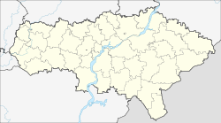
Ivantejewka (Saratov)
| Village
ivanteyevka
Ивантеевка
|
||||||||||||||||||||||||||||||||
|
||||||||||||||||||||||||||||||||
|
||||||||||||||||||||||||||||||||
Iwantejewka ( Russian Иванте́евка ) is a village (selo) in Saratov Oblast in Russia with 6100 inhabitants (as of October 14, 2010).
geography
The place is about 225 km as the crow flies northeast of the Saratov Oblast Administrative Center and 130 km southwest of Samara in the steppe landscape to the left of the Volga . It is located on the left bank of the Volga tributary Kleiner Irgis (Maly Irgis) at the confluence of the left tributary Chernava , which is significantly larger there than the Kleine Irgis itself.
Iwantejewka is the administrative center of the Ivantejewski Rajons and the seat of the "municipal entity" Iwantejewskoje munizipalnoje obrasowanije with the status of a rural community (selskoje posselenije), which also includes the 15 km west-southwestern settlement (possjolok) Mirny.
history
The place was founded in 1768 and was initially inhabited by Old Believers , serfs , Cossacks and soldiers who fled from the central areas of the Russian Empire . The original name was Koslowka and referred to the place of origin of one of the groups, the city of Koslow (today Michurinsk in Tambov Oblast ). In the 19th century at the latest, the current name came into use after the town of Ivanteevka near Moscow . From 1780 the village belonged to the Ujesd Chwalynsk of the Saratov governorate, from 1797 to the Saratov governorate . In 1835 the Ujesd Nikolajewsk (now Pugachev ), newly formed to the left of the Volga , was transferred to the newly founded Samara Governorate in 1851 . In 1861 Iwantejewka became the seat of a Volost .
After the administrative headquarters were renamed, the Ujesd was also called Pugatschowski from 1918 . On July 23, 1928 Iwantejewka became the administrative seat of a Rajon (initially until 1930 as part of the Pugachovsky okrug formed from the Ujesd ) of the Lower Volga region (Nizhne-Wolschski krai), from which the Saratov region emerged in 1934 and finally the Saratov region in 1936.
In 1964 the Rajon was temporarily dissolved and its territory joined the Pugachovsky Rajon, but at the end of 1967 it was expelled again. From 1982 to 1991 Ivanteevka had urban-type settlement status .
Population development
| year | Residents |
|---|---|
| 1859 | 3392 |
| 1897 | 4982 |
| 1939 | 3600 |
| 1959 | 2899 |
| 1970 | 3164 |
| 1979 | 4391 |
| 1989 | 6224 |
| 2002 | 6173 |
| 2010 | 6100 |
Note: from 1897 census data
traffic
Ivantejewka is bypassed to the east by the regional road Samara - Pugachev - Engels - Volgograd (formerly R226, today on the territory of Oblast 36R-00002).
Almost 4 km northwest of the town center is the Topoljok train station at 90 km of the line that has been connecting from Zvezda near Tschapajewsk in the Samara Oblast to Pugachev ( Pugachovsk station ) since 1969 , from where other routes start, including to Yershov since 1897 .
Web links
Individual evidence
- ↑ a b Itogi Vserossijskoj perepisi naselenija 2010 goda. Tom 1. Čislennostʹ i razmeščenie naselenija (Results of the All-Russian Census 2010. Volume 1. Number and distribution of the population). Tables 5 , pp. 12-209; 11 , pp. 312–979 (download from the website of the Federal Service for State Statistics of the Russian Federation)

