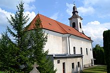
Jedľové Kostoľany
| Jedľové Kostoľany | ||
|---|---|---|
| coat of arms | map | |

|
|
|
| Basic data | ||
| State : | Slovakia | |
| Kraj : | Nitriansky kraj | |
| Okres : | Zlaté Moravce | |
| Region : | Nitra | |
| Area : | 27.294 km² | |
| Residents : | 896 (Dec. 31, 2019) | |
| Population density : | 33 inhabitants per km² | |
| Height : | 400 m nm | |
| Postal code : | 951 96 | |
| Telephone code : | 0 37 | |
| Geographic location : | 48 ° 28 ' N , 18 ° 30' E | |
| License plate : | ZM | |
| Kód obce : | 500364 | |
| structure | ||
| Community type : | local community | |
| Administration (as of November 2018) | ||
| Mayor : | Dušan Kazimír | |
| Address: | Obecný úrad Jedľové Kostoľany č. 297 951 96 Jedľové Kostoľany |
|
| Website: | www.jedlovekostolany.sk | |
| Statistics information on statistics.sk | ||
Jedľové Kostoľany (until 1948 Slovak "Jedľové Kostolany" - to 1927 "Jedľové Kostoľany"; Hungarian Fenyőkosztolány ) is a municipality in West -Mitte of Slovakia with 896 inhabitants (December 31, 2019) that the circle Okres Zlaté Moravce , part des Nitriansky kraj , and is located in the traditional Tekov landscape .
geography
The municipality is located on the southern slope of the Tribetz Mountains and on the northern slope of the Pohronský Inovec Mountains on the upper reaches of the Žitava . The center of the village is at an altitude of 400 m nm and is 14 kilometers from Zlaté Moravce .
Officially, the municipality has no municipal parts, but there are still twelve settlements separate from the main town, locally called štál , Mz. Štále : Borisko, Bošiakov štál, Brezovo, Dolné Lúčno, Drienky, Horné Lúčno, Hujavovce, Levasovský štál, Lukáč , Modoš and Nemčekovce.
Neighboring parishes are Malá Lehota in the north and northeast, Veľká Lehota in the east, Obyce in the south, Hostie in the west and Skýcov in the northwest.
history
The place was first mentioned in writing in 1387 as Fenyeukoztholvan , but the area was already mentioned in 1075 in connection with the Fenio Saunica brook , as was the Church of All Saints in 1332. The village belonged to the estate of the Hrušov Castle , which maintained the Živán watchtower here . In 1424 toll was charged here. In the 17th century the village became part of the Topoľčianky estate . A glassworks worked here in the 18th century. In 1828 there were 107 inhabitants and 691 inhabitants. Lignite mining began in 1859 after several unsuccessful attempts from previous centuries and lasted until 1924.
Until 1918, the place in Bars County belonged to the Kingdom of Hungary and then came to Czechoslovakia or now Slovakia.
population
According to the 2011 census, Jedľové Kostoľany had 941 inhabitants, of which 901 were Slovaks, three Czechs and one Roma and one Ukrainian each; one resident indicated a different ethnic group. 34 residents gave no information in this regard. 819 residents committed themselves to the Roman Catholic Church, two residents each to the Evangelical Church AB and the Greek Catholic Church and one resident each to the Jehovah's Witnesses, the Orthodox Church and the Reformed Church. 57 residents had no denomination and the denomination of 58 residents was not determined.
Buildings
- Roman Catholic Church of All Saints in Classical style from 1796
- Ruins of the Živán watchtower
Individual evidence
- ↑ 2011 census by ethnicity (Slovak) ( Memento from October 6, 2014 in the Internet Archive )
- ↑ 2011 census by denomination (Slovak) ( Memento from September 7, 2012 in the Internet Archive )
Web links
- Entry on e-obce.sk (Slovak)


