La Rochette (Seine-et-Marne)
| La Rochette | ||
|---|---|---|

|
|
|
| region | Île-de-France | |
| Department | Seine-et-Marne | |
| Arrondissement | Melun | |
| Canton | Melun | |
| Community association | Melun Val de Seine | |
| Coordinates | 48 ° 30 ′ N , 2 ° 40 ′ E | |
| height | 36-98 m | |
| surface | 5.86 km 2 | |
| Residents | 3,412 (January 1, 2017) | |
| Population density | 582 inhabitants / km 2 | |
| Post Code | 77000 | |
| INSEE code | 77389 | |
| Website | http://www.ville-la-rochette.fr/ | |
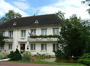
 La Rochette Town Hall |
||
La Rochette is a French municipality with 3412 inhabitants (as of January 1 2017) in the department of Seine-et-Marne in the region Ile-de-France . It belongs to the arrondissement of Melun and the canton of Melun . The inhabitants are called Rochettois .
geography
La Rochette is located on the Seine , 55 kilometers southeast of Paris . La Rochette is surrounded by the neighboring communities of Melun in the north, Vaux-le-Pénil in the northeast, Livry-sur-Seine in the east, Chartrettes and Bois-le-Roi in the southeast, Fontainebleau in the south and Dammarie-les-Lys in the west.
history
La Rochette is first mentioned in a document in 1047. Viticulture in today's municipal area is documented as early as the 13th century.
Population development
| 1962 | 1968 | 1975 | 1982 | 1990 | 1999 | 2006 | 2011 |
|---|---|---|---|---|---|---|---|
| 2,903 | 2,877 | 3,096 | 2,992 | 2,861 | 2,759 | 2,930 | 3.151 |
Attractions
See also: List of Monuments historiques in La Rochette (Seine-et-Marne)
- Notre-Dame de la Visitation church, built in the 13th century in Gothic style (with a font from the 12th / 13th centuries)
- Saint Paul Church
- Castle ( Monument historique )
- Fontainebleau forest to the south of the commune
literature
- Le Patrimoine des Communes de la Seine-et-Marne . Flohic Editions, Volume 2, Paris 2001, ISBN 2-84234-100-7 , pp. 896-899.

