Combs-la-Ville
| Combs-la-Ville | ||
|---|---|---|

|
|
|
| region | Île-de-France | |
| Department | Seine-et-Marne | |
| Arrondissement | Melun | |
| Canton | Combs-la-Ville (main town) | |
| Community association | Grand Paris Sud Seine-Essonne-Sénart | |
| Coordinates | 48 ° 39 ′ N , 2 ° 33 ′ E | |
| height | 43-91 m | |
| surface | 14.48 km 2 | |
| Residents | 22,383 (January 1, 2017) | |
| Population density | 1,546 inhabitants / km 2 | |
| Post Code | 77380 | |
| INSEE code | 77122 | |
| Website | http://www.combs-la-ville.fr/ | |
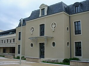
 Mairie of Combs-la-Ville |
||
Combs-la-Ville is a French commune with 22,383 inhabitants (as of January 1, 2017) near Paris . It is located in the department of Seine-et-Marne in the region Ile-de-France on the river Yerres . Combs-la-Ville is the main town ( chef-lieu ) of the canton of Combs-la-Ville . The inhabitants of the municipality call themselves Combs-la-Villais .
traffic
Combs-la-Ville is connected to the RER D and is on the Paris – Marseille railway line .
Neighboring communities
- To the north are the municipalities of Varennes-Jarcy , Villemeneux and Brie-Comte-Robert .
- To the east is the municipality of Évry-Grégy-sur-Yerres .
- In the south are the municipalities of Lieusaint and Moissy-Cramayel .
- Tigery is in the southwest .
- To the west, Quincy-sous-Sénart borders on Combs-la-Ville.
history
636 the place cumbis is given by King Dagobert I to the Abbey of Saint-Vincent. Louis XVIII before he became king of France, he resided in Combs-la-Ville.
Population development
| 1962 | 1968 | 1975 | 1982 | 1990 | 1999 | 2006 | 2011 |
|---|---|---|---|---|---|---|---|
| 4 692 | 6 192 | 11 093 | 13 759 | 19 973 | 20 953 | 21 603 | 21 908 |
Attractions
- Saint Vincent Church
- Sommeville School
- Château de la Fresnaye
- Rue de Vignes
- Château des maronniers (old town hall)
- Forêt de Sénart
- Parcs Mennechy, Arthur-Chaussy and Central
Twin cities
- Duderstadt , Lower Saxony, Germany, since 1968
- Dali , Cyprus, since 1978
- Oswestry , Shropshire, England, United Kingdom, since 1980
- R'Kiz , Mauritania, since 1986
- Petite-Île , Réunion, since 1992
- Salaberry-de-Valleyfield , Quebec, Canada, since 1998
- Baia Mare , Maramureș, Romania, since 2009
Personalities
- Victor Cherbuliez (1829–1899), writer
- Gustave Caillebotte (1848-1894), impressionist painter
- Laurent Tailhade (1854–1919), poet and satirist
- René Lalique (1860–1945), jewelry artist
- Helena Rubinstein (1870–1965), entrepreneur
- Edmonde Charles-Roux (1920–2016), writer, journalist and resistance fighter
- Bernard Tapie (* 1943), entrepreneur
- Laurent Fignon (1960–2010), racing cyclist
- Patricia Girard (* 1968), athlete (sprint)
- Chris Mavinga (* 1991), soccer player
literature
- Le Patrimoine des Communes de la Seine-et-Marne. Flohic Editions, Volume 1, Paris 2001, ISBN 2-84234-100-7 , pp. 303-305.
Web links
Commons : Combs-la-Ville - Collection of images, videos and audio files
- Combs-la-Ville at annuaire-mairie.fr (French)
