
Landwehr Canal
| Landwehr Canal | ||||||||||||||||||||||||||||||||||||||||||||||||||||||||||||||||||||||||||||||||||||||||||||||||||||||||||||||||||||||||||||||||||||||||||||||||||||||||||||||||||||||||||||||||||||||||||||||||||||||||||||||||||||||||||||||||||||||||||||||||||||||||||||||||||||||||||||
|---|---|---|---|---|---|---|---|---|---|---|---|---|---|---|---|---|---|---|---|---|---|---|---|---|---|---|---|---|---|---|---|---|---|---|---|---|---|---|---|---|---|---|---|---|---|---|---|---|---|---|---|---|---|---|---|---|---|---|---|---|---|---|---|---|---|---|---|---|---|---|---|---|---|---|---|---|---|---|---|---|---|---|---|---|---|---|---|---|---|---|---|---|---|---|---|---|---|---|---|---|---|---|---|---|---|---|---|---|---|---|---|---|---|---|---|---|---|---|---|---|---|---|---|---|---|---|---|---|---|---|---|---|---|---|---|---|---|---|---|---|---|---|---|---|---|---|---|---|---|---|---|---|---|---|---|---|---|---|---|---|---|---|---|---|---|---|---|---|---|---|---|---|---|---|---|---|---|---|---|---|---|---|---|---|---|---|---|---|---|---|---|---|---|---|---|---|---|---|---|---|---|---|---|---|---|---|---|---|---|---|---|---|---|---|---|---|---|---|---|---|---|---|---|---|---|---|---|---|---|---|---|---|---|---|---|---|---|---|---|---|---|---|---|---|---|---|---|---|---|---|---|---|---|---|---|---|---|---|---|---|---|---|---|---|---|---|---|---|
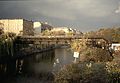
 Houseboats on the flood ditch of the Landwehr Canal at the canal lower lock in the Great Tiergarten |
||||||||||||||||||||||||||||||||||||||||||||||||||||||||||||||||||||||||||||||||||||||||||||||||||||||||||||||||||||||||||||||||||||||||||||||||||||||||||||||||||||||||||||||||||||||||||||||||||||||||||||||||||||||||||||||||||||||||||||||||||||||||||||||||||||||||||||
| abbreviation | LWK | |||||||||||||||||||||||||||||||||||||||||||||||||||||||||||||||||||||||||||||||||||||||||||||||||||||||||||||||||||||||||||||||||||||||||||||||||||||||||||||||||||||||||||||||||||||||||||||||||||||||||||||||||||||||||||||||||||||||||||||||||||||||||||||||||||||||||||
| length | 11 km | |||||||||||||||||||||||||||||||||||||||||||||||||||||||||||||||||||||||||||||||||||||||||||||||||||||||||||||||||||||||||||||||||||||||||||||||||||||||||||||||||||||||||||||||||||||||||||||||||||||||||||||||||||||||||||||||||||||||||||||||||||||||||||||||||||||||||||
| Built | 1845-1850 | |||||||||||||||||||||||||||||||||||||||||||||||||||||||||||||||||||||||||||||||||||||||||||||||||||||||||||||||||||||||||||||||||||||||||||||||||||||||||||||||||||||||||||||||||||||||||||||||||||||||||||||||||||||||||||||||||||||||||||||||||||||||||||||||||||||||||||
| Expanded | 2009–2014 and renovated | |||||||||||||||||||||||||||||||||||||||||||||||||||||||||||||||||||||||||||||||||||||||||||||||||||||||||||||||||||||||||||||||||||||||||||||||||||||||||||||||||||||||||||||||||||||||||||||||||||||||||||||||||||||||||||||||||||||||||||||||||||||||||||||||||||||||||||
| Beginning | Spree in Berlin-Kreuzberg | |||||||||||||||||||||||||||||||||||||||||||||||||||||||||||||||||||||||||||||||||||||||||||||||||||||||||||||||||||||||||||||||||||||||||||||||||||||||||||||||||||||||||||||||||||||||||||||||||||||||||||||||||||||||||||||||||||||||||||||||||||||||||||||||||||||||||||
| The End | Spree in Berlin-Charlottenburg | |||||||||||||||||||||||||||||||||||||||||||||||||||||||||||||||||||||||||||||||||||||||||||||||||||||||||||||||||||||||||||||||||||||||||||||||||||||||||||||||||||||||||||||||||||||||||||||||||||||||||||||||||||||||||||||||||||||||||||||||||||||||||||||||||||||||||||
| Descent structures | two: upper lock, lower lock | |||||||||||||||||||||||||||||||||||||||||||||||||||||||||||||||||||||||||||||||||||||||||||||||||||||||||||||||||||||||||||||||||||||||||||||||||||||||||||||||||||||||||||||||||||||||||||||||||||||||||||||||||||||||||||||||||||||||||||||||||||||||||||||||||||||||||||
| Historical precursors | "Sheep pit" | |||||||||||||||||||||||||||||||||||||||||||||||||||||||||||||||||||||||||||||||||||||||||||||||||||||||||||||||||||||||||||||||||||||||||||||||||||||||||||||||||||||||||||||||||||||||||||||||||||||||||||||||||||||||||||||||||||||||||||||||||||||||||||||||||||||||||||
| Outstanding structures | 36 bridges | |||||||||||||||||||||||||||||||||||||||||||||||||||||||||||||||||||||||||||||||||||||||||||||||||||||||||||||||||||||||||||||||||||||||||||||||||||||||||||||||||||||||||||||||||||||||||||||||||||||||||||||||||||||||||||||||||||||||||||||||||||||||||||||||||||||||||||
| Responsible WSD | Federal Waterways and Shipping Administration and Berlin Waterways and Shipping Office | |||||||||||||||||||||||||||||||||||||||||||||||||||||||||||||||||||||||||||||||||||||||||||||||||||||||||||||||||||||||||||||||||||||||||||||||||||||||||||||||||||||||||||||||||||||||||||||||||||||||||||||||||||||||||||||||||||||||||||||||||||||||||||||||||||||||||||
|
course
|
||||||||||||||||||||||||||||||||||||||||||||||||||||||||||||||||||||||||||||||||||||||||||||||||||||||||||||||||||||||||||||||||||||||||||||||||||||||||||||||||||||||||||||||||||||||||||||||||||||||||||||||||||||||||||||||||||||||||||||||||||||||||||||||||||||||||||||

The Landwehr Canal (LWK) is a federal waterway in Berlin and is legally part of the Spree-Oder-Wasserstraße (SOW). As a side canal of the Berlin Spree section of the Spree-Oder waterway, it connects the Spree at the Osthafen (SOW-km 21.14) with the Spree at Spreekreuz in Charlottenburg (SOW-km 9.08) and has a length of 10.73 Kilometers through the districts of Kreuzberg , Neukölln , Tiergarten and Charlottenburg . The LWK is designated as waterway class I. The Berlin Waterways and Shipping Office is responsible for administration .
The kilometering begins at the Spreekreuz in Charlottenburg. The canal has a usable width of 22 meters and is two meters deep in the middle. The average height difference from east to west is two meters and is balanced out at the ends of the canal by the canal step at km 10.57 (upper lock and flood ditch with weir) and the canal step at km 1.67 (lower lock and flood ditch with weir).
Name and founding circumstances
The term Landwehr or Landhege referred to a field fortification in front of the city wall in late medieval fortress construction. It often marked the outer limits of the urban sphere of influence. Even before 1700 (the exact time is not known) a Landwehr ditch was dug in front of the Berlin city wall between Schlesisches Tor and Halleschem Tor . This ditch, originally called Schafgraben or Floßgraben , was initially a drainage ditch that diverted water from the marshland south of what was then Berlin into the Spree. It was expanded into a raft ditch in 1705 in order to facilitate the transport of wood to the Royal Lumberyard at Halleschen Tor.
history
Planning and construction
With the beginning of industrialization , the volume of goods and goods grew, and with it the need for transport. Since the roads were not able to cope with this increase and the rail traffic could only be loaded supra-regionally, the importance of the waterways increased for regional and inner-city traffic.

In the early 19th century, the transport capacity of the Spree was no longer sufficient. In particular, the establishment in the heart of Berlin city lock in Spreekanal could no longer meet the requirements. The lock chambers were too narrow and too short, the waiting times unreasonably long. The idea of a waterway was born, which should divert through traffic around the outside of the city walls. A plan from 1818 provided for a bypass canal - the Landwehr Canal - with a floor width of 11.30 meters and a minimum water depth of 1.26 meters. The preparations for the construction were well advanced when King Friedrich Wilhelm III. the company canceled in 1820 for cost reasons.
In 1840 the city planner and garden architect Peter Joseph Lenné received the order for various larger projects in the south of Berlin from the Prussian King Friedrich Wilhelm IV . Parallel to the development of the Köpenicker Feld and the construction of the Luisenstadt Canal , he pursued the old idea of a relief canal for the Spree. In addition to its actual purpose, it was intended to provide drainage for the fields designated as building land and facilitate the transport of materials to the construction sites. Bureaucratic processes caused considerable delays. When construction began in 1845, the exact route was not even fixed in all points. The engineer Helfft, as construction manager of the canal, described the route:
The construction work was accelerated by the fact that the Berlin magistrate declared the canal construction a job creation measure in 1848. In this way, “paid work should appear satisfactory”. In addition, a piece rate was agreed, but a steam engine was also used. The workers revolted and 12 of them were even shot by the gendarmes.
The inauguration took place on September 2, 1850. The press and the Berlin population hardly took notice of it, after all, the canal was far away, still outside the city walls.
Ownership and responsibilities in the 19th and 20th centuries
Formally, the king was considered the owner and in his representation the KMBC (Royal Ministerial Building Commission for the Shipping Canal in the Köpenicker Felde), 1841.

“In 1876 the canal bank roads and the bridges went over Landwehrstadt and Luisenstädt. Canal in municipal ownership over. […] The canal itself, however, remains in the hands of the state. ”After the city took over the construction of the Schöneberg harbor on its account, a general cost sharing was introduced.

"In 1989 a total of 23 institutions from the Senate Administration and from 5 districts were responsible for the various tasks on and around the canal, which made comparatively uniform or coordinated treatment unlikely."
In June 1886 ordinances came into force that regulated the operation of steam navigation on the canal. After that there was an increase in tugboat operation.
Human dramas

In addition to the revolt, which was bloodily suppressed during the construction, the murder of Rosa Luxemburg and Karl Liebknecht on January 15, 1919 is commemorated on the edge of the Landwehr Canal and the Great Zoo . Rosa Luxemburg was shot dead in the car after interrogation during the transport. The murderers, members of a volunteer corps , threw their bodies into the canal. Her body could not be recovered until the end of May 1919.
On the night of February 17, 1920, after a suicide attempt at the Bendler Bridge, Anna Anderson was rescued from the Landwehr Canal. She claimed to be the daughter of the Russian tsar, Anastasia Nikolajewna Romanowa .
Tunneling under the S-Bahn
With the expansion of the S-Bahn network in the 1930s, a north-south connection was planned as a tunnel route under the city center . Construction began in 1934. Two lines led south from the Anhalter Bahnhof, which still ran together under the Landwehr Canal and only branched under the Anhalter Güterbahnhof:
The southwest section ( Potsdamer Platz -) Anhalter Bahnhof - Großgörschenstrasse (- Schöneberg ) was opened on 9 Opened to traffic in October 1939, the section Anhalter Bahnhof - Yorckstrasse ( Papestrasse ) on November 5, 1939.
Second World War
Possible protective measures
Under the impression of the increasing bombing of Berlin, the responsible hydraulic engineering department paid particular attention to the critical points on the two waterways, the Spree and Landwehr Canal, tunneled under by the north-south railway. Two communications on this are published in the Landwehrkanal 1990 report:
- "May 25, 1943. Completion of the reinforcement and re-sealing work on the tunnel ceiling of the north-south railway under the Landwehr Canal (4 layers of bitumen cardboard and a 15 cm thick protective concrete layer.) "
- "8.8.1944. Communication on the protection of tunnels under Berlin watercourses: since considerations to protect the tunnels mentioned by sandboats that are to be driven over them prove to be impractical, the decision is made to go to the most endangered places ( Friedrichstraße / Spreetunnel station and Anhalter Bahnhof / Landwehrkanal ) To install iron gates to protect the tunnels from filling up in the event of bomb hits; this only happens in the Friedrichstrasse and Großgörschenstrasse tunnels. "
Defense function
In addition to train stations and their track areas with the variety of functional buildings and track sections, urban planning features such as watercourses were preferred defensive focal points or lines in the military conflict. In the final battle for Berlin , these included the Spree and the Landwehr Canal in particular. In Kreuzberg, the canal also shielded the Anhalter Bahnhof area from the south. The area there was part of the inner defensive ring of the city.
After the Soviet army had reached the Oder on a broad front at the beginning of February 1945 and crossed it at Küstrin , the major attack on Berlin began on April 16 . As early as April 25, the city was surrounded all around and units had already penetrated far into the city from the east.
Front line Landwehr Canal
Soviet troops crossed the eastern part of the canal on April 25, 1945 in the area of Lohmühleninsel , but they were not allowed to advance further in the Friedrichstrasse area for a longer period of time.
It was not until April 27, 1945 that Soviet combat groups of the 8th Guard Army under Colonel General Tschuikow (Army Group of Field Marshal Schukow ) arrived in the Schöneberger Brücke area along the Landwehr Canal to Hallesches Tor (coming from Tempelhof Airport ). The bridges over the canal in this area were blown up by a mobile Wehrmacht commando on the evening of April 26th . An eyewitness observed the destruction of the Großbeeren Bridge and the Hallesche Tor Bridge and she could still hear the detonation from the direction of the Zossener Bridge.

After a day of preparation, the Soviet troops crossed the canal on April 29, 1945 via the Möckernbrücke elevated railway ruins (currently: U1 / U7 underground lines ) and occupied the area around Anhalter Bahnhof on April 30 . On May 1 or 2, 1945, the tunnel ceiling of the S-Bahn directly under the Landwehr Canal was blown up by commanders who could not be determined with certainty and with an intent that was previously only discussed speculatively, triggering a water ingress into the north-south tunnel. There were hundreds (according to other sources even thousands) seeking protection who had fled from the artillery and the fighting in the streets to the supposed safety of the tunnel and its underground stations. According to one illustration (documented by photos) the detonation, which took place with high explosive force, tore the canal floor several meters wide and up to 40 meters long.
Water drainage in the tunnel
The water "flowed to the Friedrichstrasse station and from here it reached the subway via the so-called 'Rennsteig' '."
It took until the beginning of September before the water could be lowered; Pumping out began in October 1945.

On May 25, 1945, the Soviet city commandant Bersarin ordered the pumping out of the north-south tunnel and, in the meantime, also of overflowing subway shafts - especially since there was a risk of epidemics because of the only partially recovered corpses. The work progressed slowly due to the lack of material and equipment; the canal diverted for repair was not restored until 1946.
Damage to bridges and the canal
“During the Second World War there was great destruction on the Landwehr Canal, primarily on the bridges (16 of the 28 road and pedestrian bridges and 3 of the 7 railway bridges were totally destroyed), while the canal walls remained largely intact and the locks were only damaged. In the area around the canal, especially in the central area, however, there was so much bomb damage that the urban structure there has been completely changed today. In the years 1945–1955 the canal was cleared of rubble, bridge parts, etc. and repaired or repaired in a makeshift manner. "
Restoration
"Siemens Bau-Union was able to start cleaning up the Landwehr Canal on May 25 and determine the extent of the damage."
“During the Second World War, both locks were damaged but not destroyed. Their repairs in the first post-war years were somewhat provisional, but according to requirements. In 1951, both locks were placed under the authority of the Main Waterways Office in Berlin by an Allied resolution, which they operated until 1990. The Oberschleuse [Schlesische Brücke] was practically not used from 1961 to 1989, but according to the circumstances it was relatively well maintained. ”In 1964 the old Mühlendammschleuse [lower sluice ] next to the Mühlendamm emergency bridge was demolished .
post war period

After the devastation of the Second World War, when huge amounts of rubble had to be removed, the Landwehr Canal once again had an important function as a transport route for the cargo ships.
"In 1959/60 the Schöneberg harbor was filled in for reasons of flowing canal roads and in 1963/64 the urban harbor was partially filled."
For the period up to the fall of the Berlin Wall, “in summary, about shipping traffic on the Landwehr Canal is that it is irrelevant in the city center. Shipping, however, occupies an important position which cannot be dispensed with in the future either. [SenStadtUm 1984, p. 11 f.] “In the inner-city traffic of West Berlin, the only waterway connection (“ for supervisory and construction vehicles ”) ran from the Landwehr Canal via the Neukölln Shipping Canal to the Teltow Canal .
After the reunification of Berlin
As in the post-war period, the increasing motorization increasingly shifted freight traffic to the road, which gradually led to the canal losing its importance as a transport route for bulk goods. It is now almost only used by excursion boats and pleasure boats. The bank fortifications with their railings and stairs are under monument protection .
The Berlin Lapidarium is housed in the Hallesches Ufer pumping station , which is also a listed building. Until 2009, stone monuments (especially from Siegesallee ) that are not used or that need special protection were kept here. In May 2009, all the statues from the Lapidarium were moved to the Spandau Citadel .
Features and properties

description
With a minimum depth of 1.57 meters, the Landwehr Canal had a water level width of 22.60 meters, but was only ten meters wide at the bottom, so the banks were steeply sloping so that ships could not dock directly. The water depth could be regulated through lock gates at both end points (upper lock on the Lohmühleninsel and lower lock ); it never fell below 1.50 meters, regardless of the water level of the Spree. Originally there were two ports on the canal, the Urban harbor in the district of Kreuzberg and Schöneberg port on the site of today - by Felix Mendelssohn Bartholdy named - parks . From the Urbanhafen , of which only a much smaller, narrow basin has remained, the Luisenstädtischer Kanal led over the Wassertorplatz , Oranienplatz and the Engelbecken to the north to the Spree. It was filled in in 1926/1927 and replaced by a wide, park-like strip of green in places. Lenné had tree-lined promenades built on the Landwehr Canal to allow residents to relax in the newly emerging city districts. Whether this purpose could be achieved at that time is at least questionable: Berlin did not yet have a sewer system , the wastewater flowed untreated into the sewer, in which the residents also washed and bathed.
The canal's capabilities were soon exhausted. During encounters or overtaking maneuvers, the bank reinforcements were repeatedly damaged, sand broke through and impaired shipping. According to a decree of 1880, traffic was only allowed to go in one direction at a time. The first expansion took place between 1883 and 1890. The floor was widened from ten to 22 meters and the canal was bordered with steep banks over almost its entire length. The new water depth was now 1.75 meters. Bridges, which previously had to be pulled up every time the ship passed, have been raised.
After the slopes were removed, the canal had a usable width of 22 meters, ships could dock without obstructing the through traffic. The second major renovation between 1936 and 1941 brought further improvements. Locks were relocated and expanded. In the middle of the fairway, the canal was now two meters deep. However, the bridges remained unchanged - there is little room upwards when passing through.
Locks

As was customary in 1850, the locks were built with two aisles with staggered heads. The lock chamber length between the jambs was 50.22 meters (160 feet ). The unit of measurement foot , which was common in Prussia at that time, refers to the Rhine foot with a length of 313.85 millimeters.
The chamber was 10.04 meters (32 feet) wide. In consideration of the small tow steamers to be expected , the gate width was set at 7.53 meters (24 feet). In the years 1936–1941, the Landwehr Canal Oder was made accessible to ships. Both locks were rebuilt. The upper lock, completed in 1939, had two lower gates as a special feature. Their usable length differs between 72.10 meters and 58.85 meters. The chamber width is 19.70 meters, the gate width in the upper head 8.80 meters and in the lower head each 8.50 meters. The lower lock was opened to traffic in 1941. It has a usable length of 60.00 meters and is 10.50 meters wide. The gates are 8.50 meters wide. At the lower lock , the position of the weir and the lock were swapped. This resulted in better lines for shipping.
The Berlin custom barges of the time , which were based on the Berlin standard , were adapted to the conditions of the waterway such as lock dimensions and curve radii. Their length was 46.20 meters and their width was 6.60 meters. The draft rarely reached 1.75 meters and her deadweight 350 tons . The dimensions may vary, as they have occasionally been raised to increase the load capacity.
bridges
A total of 36 bridges cross the canal, most of which are road bridges. The list includes two bridges that lead underground lines over the Landwehr Canal.
See: Bridges over the Landwehr Canal
Redevelopment
Investigations of the canal bank have shown that the bank reinforcement had been undermined on some stretches by waves from boats and ships traveling on the canal. In the spring of 2007, among other things, this resulted in a sagging of the embankment wall at a ship landing stage. The Berlin Waterways and Shipping Office (WSA) then had safety measures carried out, which included heavily controversial tree felling and blocking the canal to shipping. A citizens' initiative collected over 25,000 signatures against the action of the office within four months and managed to initiate a mediation process for the rehabilitation and future use of the canal. On December 10, 2007, with the participation of authorities, tradespeople and representatives of the citizens' initiative, an appropriate working alliance was concluded under the name “Future Landwehr Canal”. In their working alliance on January 21, 2008, the participants in the forum stated that the aim of the mediation process was “sustainable by all those involved, ie. H. as economically , ecologically and socially acceptable and to work respected, which is under consideration of preservation and technically feasible solutions for the many issues both for the current situation as for the future of the Landwehr Canal in Berlin in a consensus-building process. "In addition Mediation Forum and working groups was dissolved exploratory groups and worked constructively together in further meetings on a variety of topics.
A special feature is the two-pronged nature of the process: on the one hand, it is about specific agreements about the intended sewer rehabilitation, on the other hand it has proven to be useful and in some cases necessary to include the sewer environment. In this way, both a consensus-oriented overall solution is sought as part of long-term planning and, along the way, current questions are mutually clarified and decisions are made.
After a consensual agreement could not be reached in mediation on the demand for integrated renovation planning, part of the citizens' initiative left the negotiations and since summer 2008 has been advertising with an annual paddle parade under the motto Landwehr Canal for All! for a sustainable renovation of the canal, which, in addition to ecological aspects and a priority for emission-free means of transport, also includes the improvement of recreational use, barrier-free access for the disabled and a cross-free footpath and cycle path along both sides of the canal. The agreement was finally reached in December 2013. This resulted in cost savings of 113 million euros compared to previous plans.
In 2009 the Berlin Waterways and Shipping Authority carried out extensive inspection and construction work along the entire canal. Between November 2009 and March 2010 the canal was completely closed to shipping because the first reinforcement and renovation work was being carried out on the embankment walls. The embankment walls in the area of the Maybachufer, which completely slipped down in May 2007, and other parts of the embankment fortifications must be repaired. Alternative berths have been made available for the passenger shipping companies affected .
In order to be able to permanently eliminate all damage - partly replacing wooden sheet pile walls, renewing the flat brick layer that lies under the water surface and largely supports the walls, consolidation of washouts and cavities - an official plan approval procedure must be carried out. In all likelihood, this can only begin in August 2019, so the subsequent building permit will only be issued in July 2021. The start of construction is not expected before November 2021.
Landwehr Canal on the Görlitzer Ufer, 1990

Promenade in Kreuzberg (view of the Baerwaldbrücke )

Bridges over the Landwehr Canal

Landwehr Canal in Kreuzberg ( Reichpietschufer /
Schöneberger Ufer)
View of the Landwehr Canal from the Koethener Bridge in west direction

1978 postage stamp with the Bendler Bridge and the Shell House

Canal bank at the Tiergarten lock


_1978,_MiNr_579.jpg)

Remarks
- ↑ "The exact date and the circumstances are controversial": Uwe Dannenbaum: The unexplained tragedy. In: Berliner Morgenpost . 19./20. May 1991. Also the source interpretations by Karen Meyer: The flooding of the Berlin S-Bahn tunnel. Ed .: Kunstamt Kreuzberg, GVE, Berlin 1992, did not lead to any definitive evidence.
- ^ "SS men blew up a six-kilometer-long S-Bahn tunnel leading under [...] the Spree and the Landwehr Canal, in which thousands of people had sought protection. […] The tunnel wasn't just crammed with civilians. There were also four hospital trains with wounded soldiers. ”[The fact that SS men blew up says nothing about the issuing of orders. Other sources call "pioneers".] In: Cornelius Ryan: The last fight. Munich 1975, p. 380, (original 1966; reprint: Konrad-Theiss-Verlag, Stuttgart 2015, ISBN 978-3-8062-3026-0 , with a foreword by Johannes Hürter , who criticizes end-of-war research there )
- ↑ The last sentence obviously does not apply in its generalization - for example in Kreuzberg-Südost; where the canal did not become the front line, the urban structure was largely preserved. The damage “in the vicinity” (city center) can be traced back to the Soviet artillery more than from bombs. Any reference to the destruction caused by the blasting in 1945 and the improvised restoration is missing in the report, which was also drawn up for the purpose of taking stock of damaged or weak points.
literature
- Bappert, Geyer, Wenzel: Landwehrkanal report 1990. Client: State Monument Office Berlin , Waterways and Shipping Office Berlin in association with the Senate Department for Urban Development and Environmental Protection, Section III, B. 43.
- Help: The Landwehr Canal near Berlin, built in the years 1845 to 1850. In: Zeitschrift für Bauwesen . Volume 2, 1852, col. 481–495, plates 74–79. ( Digital copy in the holdings of the Central and State Library Berlin )
- Herbert Schwenk: Berlin urban development from A – Z. Edition Luisenstadt, Berlin 2001, ISBN 3-89542-100-6 , p. 179 f.
Movies
- Experience Berlin by ship. On the Landwehr Canal. Documentary, Germany, 2017, 89:09 min., Script and direction: Thomas Zimolong, production: rbb , first broadcast: February 27, 2018 on rbb television , synopsis by ARD , online video available until February 27, 2019.
Web links
- Entry in the Berlin State Monument List
- Website of the Waterways and Shipping Office Berlin
- History of the Landwehr Canal with historical maps
- Wasserstadt Berlin - Numerous photos of the Landwehr Canal
- Landwehr Canal Panorama - Interactive 360 ° panorama on the bridge to the Tiergarten
Individual evidence
- ↑ Chronicle of the Waterways, Directory E, Ser. No. 55 (page 45 of 128) ( Memento from July 22, 2016 in the Internet Archive ), Federal Waterways and Shipping Administration
- ↑ Lengths of the main shipping lanes of the federal inland waterways ( memento of 10 August 2016 in the Internet Archive ), Federal Waterways and Shipping Administration
- ↑ Herbert pivot: Berliner urban development of A-Z . Edition Luisenstadt, Berlin 2001, ISBN 3-89542-100-6 , p. 179 f.
- ^ A b Peter Neumann: Berlin's most beautiful ABM project . In: Berliner Zeitung , May 10, 2017, p. 12.
- ↑ Bappert, Geyer, Wenzel: Report Landwehrkanal 1990. Client: Landesdenkmalamt Berlin / Wasserstraßen- und Schifffahrtsamt Berlin in association with the Senate Department for Urban Development and Environmental Protection, Section III, B. 43, p. 88 f. The update of the 2011 report did not change the historical part.
- ↑ Report Landwehrkanal 1990. p. 8.
- ↑ Kurt Groggert: Personenschiffahrt on the Spree and Havel . In: Berlin contributions to the history of technology and industrial culture, series of publications by the Museum for Transport and Technology, Vol. 10, p. 110. Nicolaische Verlagsbuchhandlung Beuermann GmbH, Berlin 1988, ISBN 3-87584-253-7 .
- ↑ Peter Kurth: Anastasia, the last daughter of the Tsar (Bergisch Gladbach 1988, p. 23)
- ^ Both communications in: SAP (State Archives Potsdam) Rep. 57 Wasserbaudirektion Kurmark / Potsdam; 1st communication in: 1980, p. 92; 2. Communication in: 1963, p. 193. In: Expert opinion Landwehrkanal 1990. p. 83.
- ↑ Waltraut Süßmilch: In the bunker. Ullstein Verlag, Berlin 2004, ISBN 3-548-25870-0 , p. 111.
- ↑ In the Landwehr Canal report 1990 (and also in the new version 2011), which describes the conditions of war damage, the destruction in the river bed (as well as the complex restoration work in 1945/1946 with the simplest technology and materials appropriate to the circumstances) are not mentioned. See section below: 'War Damage'.
- ↑ From the subway. In: Berliner Zeitung , June 18, 1945
- ↑ Wolfgang Kiebert: The electrical operation on the Berlin S-Bahn. Verlag B. Neddermeyer, Berlin 2013, p. 124.
- ↑ To repair the damage in Channel Tunnel and see the literature on the Berlin S-Bahn .
- ↑ Bappert, Geyer, Wenzel: Report Landwehrkanal 1990. p. 84.
- ^ Helmut Maier: Berlin-Anhalter Bahnhof. Verlag Ä + K (Aesthetics and Communication), Berlin 1985, p. 285.
- ↑ Bappert, Geyer, Wenzel: Report Landwehrkanal 1990. P. 27.
- ^ W. Natzschka: Berlin and its waterways. Duncker & Humblot, Berlin 1971. In: Report Landwehrkanal 1990. p. 163.
- ↑ Report Landwehrkanal 1990. p. 183.
- ↑ Necessary tree felling on the Viking bank? Information on the planned deforestation of the historic trees on the Landwehr Canal
- ↑ Landwehr Canal Berlin - Information on mediation about the future of the Landwehr Canal ( Memento from September 4, 2014 in the Internet Archive )
- ↑ Mediation agreement signed on baumschutz.wordpress.com
- ↑ Information from the Berlin Waterways and Shipping Office on various work on the bridges and directly in the Landwehr Canal ( Memento from May 15, 2012 in the Internet Archive )
- ↑ Landwehr Canal closed to ships until March . In: Berliner Zeitung , November 3, 2009.
Coordinates: 52 ° 29 ′ 52 ″ N , 13 ° 23 ′ 33 ″ E