
Langenberg (Rothaar Mountains)
| Langenberg | ||
|---|---|---|
 View of the Langenberg in winter from the Clemensberg |
||
| height | 843.2 m above sea level NHN | |
| location | between Niedersfeld and Willingen ; Hochsauerlandkreis , Waldeck-Frankenberg district ; North Rhine-Westphalia , Hessen ( Germany ) | |
| Mountains | Rothaar Mountains | |
| Dominance | 116 km → Großer Feldberg ( Taunus ) | |
| Notch height | 557 m ↓ Neustädter Sattel east of Stadtallendorf | |
| Coordinates | 51 ° 16 '35 " N , 8 ° 33' 30" E | |
|
||
| particularities | Highest mountain in the Rothaargebirge and North Rhine-Westphalia | |


The Langenberg is 843.2 m above sea level. NHN the highest mountain in the Rothaargebirge , in North Rhine-Westphalia and in the north-western part of Germany . It is located between Niedersfeld in the North Rhine-Westphalian Hochsauerlandkreis and Willingen in the Hessian district of Waldeck-Frankenberg .
geography
location
The Langenberg is located on the border between Westphalia and North Hesse on the seam line between Hochsauerland and Upland with the Hessian Diemelsee Nature Park on the east side, between Bruchhausen ( Olsberg ) in the north-north-west, Willingen with the locality of Hoppern in the north-east and Niedersfeld ( Winterberg ) in the south-west. According to the German basic map, its summit is located in Westphalia in the Bruchhausen district about 10 m southwest of the Hessian state border.
The Ruhr inflow Burbecke rises on the southwest flank of the Langenberg and the Gierskoppbach inflow Raken on its north flank . To the east, the mountain is passed in a south-north direction from the upper reaches of the Hoppecke , into which a small stream flows from the valley “Der Keller” to the southeast of the mountain.
Neighboring mountains are - with a height in meters (m) above sea level (NHN): Hoppernkopf ( 805 m ) in the north, Mittelberg ( 801 m ; beyond the Hoppecke) in the east, Hegekopf ( 842.9 m ; beyond the Hoppecke) in the east-southeast, Hopperkopf ( 832.3 m ) in the southeast, Clemensberg (approx. 837 m ) in the south-southwest and Auf dem Sternrodt ( 789.4 m ) in the west.
Natural allocation
The Langenberg belongs to the natural spatial main unit group Süderbergland (No. 33), in the main unit Rothaargebirge (with Hochsauerland ) (333) and in the subunit Winterberger Hochland (333.5) to the natural area Langenberg (333.58). The landscape descends to the south-west to west into the natural area of Nordheller Heights (333.57), to the north-west to north into the natural area of Schellhorn and Treiswald (333.82), which belongs to the subunit Hochsauerländer Schluchtgebirge (333.8), and to the north-east into the natural area Inneres Upland (333.90), part of the subunit Upland (333.9).
Mountain height and summit region
In front of the 842.9 m high Hegekopf , which lies 2.2 km east -south- east entirely in northern Hesse, and in front of the 841.9 m high Kahler Asten , which rises 11.8 km south-south-west near Winterberg , the 843.2 m high Langenberg the highest mountain in the Rothaargebirge; the highest accessible point in the Rothaargebirge is the 875 m high viewing platform of the Hochheideturm on the Ettelsberg ( 837.7 m , located in Willingen, Hesse) .
About 12 m south-east of the mountain summit recorded in the German base map with a height of 843.2 m is a marker on which a metal plate with the inscription "Langenberg 843 m above sea level - highest mountain in N R W" is attached. In addition, a wooden summit cross has stood there since 2010 . Around 15 m south-east of the summit and around 20 m south-west of the aforementioned national border is a trigonometric point of the German main triangular network at an altitude of 843.1 m .
In its hilltop- like summit region, where a high heath landscape extends to the east, the Langenberg is little, but otherwise mostly heavily forested.
Protected areas
At and on the Langenberg are located in Westphalia
- the nature reserve Rakenbachtal ( CDDA no. 329585; designated 2001; 38 hectares ) in the north,
- the NSG Hoppecke-Quellbach (CDDA-Nr. 389788; 2008; 17 ha) in the southeast and south,
- the Erlenbruch NSG (CDDA no. 329353; 2001; 2 ha) in the south,
- the NSG Burbecketal (. CDDA No. 389,690; 2008; 10 ha) in the southwest and
- the NSG Medebachtal and headwaters (CDDA no. 329517; 2001; 50 ha) in the northwest.
Also lie on the Westphalian side
- the landscape protection area Olsberg (CDDA no. 345105; 2004; 79.52 km² ) and, south of it,
- the LSG area of the city of Winterberg (CDDA no. 325127; 1994; 75.32 km²).
To the east the landscape falls into the Hessian fauna-flora-habitat area Ettelsberg with the Ruthenaar and Hoppecketal near Willingen (FFH no. 4717-350; 1.16 km²) and to the south-west into the Westphalian FFH area Schluchtwälder north of Niedersfeld ( FFH no. 4717-303; 1.8 km²).
Transport links and hiking
The federal highway 480 runs through the Ruhr valley to the west of the Langenberg in the section Niedersfeld– Wiemeringhausen and the federal highway 251 runs through Willingen to the east in the valleys of the Hoppecke and Itter . There are no roads leading up the mountain. The closest residential area roads branching off the aforementioned federal roads run in Niedersfeld and Hoppern.
South of the mountain are the crossroads of “Oberer Burbecker Platz” and “Unterer Burbecker Platz”. A few meters east past the summit - passing a historical boundary stone - run in a north-south direction as part of a common section of the Rothaarsteig and the Uplandsteig . The Winterberger Hochtour leads over the two aforementioned crossroads . The European long-distance hiking trail E1 runs through the Hoppecketal to the east .
photos
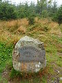
Marking stone at the summit in summer ...

… and in the winter


Individual evidence
- ↑ a b c d Topographical Information Management, Cologne District Government, Department GEObasis NRW ( information )
- ↑ Dominances and celebrities on highrisepages.de ( Memento from January 26, 2017 in the Internet Archive )
- ↑ Martin Bürgener: Geographical Land Survey: The natural spatial units on sheet 111 Arolsen. Federal Institute for Regional Studies, Bad Godesberg 1963. → Online map (PDF; 4.1 MB)
- ^ "Rakenbachtal" nature reserve in the specialist information system of the State Office for Nature, Environment and Consumer Protection in North Rhine-Westphalia , accessed on April 11, 2017.
- ↑ "Hoppecke-Quellbach" nature reserve in the specialist information system of the State Office for Nature, Environment and Consumer Protection in North Rhine-Westphalia , accessed on April 11, 2017.
- ^ "Erlenbruch" nature reserve in the specialist information system of the State Office for Nature, Environment and Consumer Protection in North Rhine-Westphalia , accessed on April 11, 2017.
- ^ "Burbeck Valley" nature reserve in the specialist information system of the State Office for Nature, Environment and Consumer Protection in North Rhine-Westphalia , accessed on April 11, 2017.
- ↑ Nature reserve "Medebachtal und Quellgebiet" in the specialist information system of the State Office for Nature, Environment and Consumer Protection in North Rhine-Westphalia , accessed on April 11, 2017.
- ↑ 4717-350 Ettelsberg with Ruthenaar and Hoppecketal near Willingen. (FFH area) Profiles of the Natura 2000 areas. Published by the Federal Agency for Nature Conservation . Retrieved November 28, 2017.
- ↑ 4717-303 canyon forests north of Niedersfeld. (FFH area) Profiles of the Natura 2000 areas. Published by the Federal Agency for Nature Conservation . Retrieved November 28, 2017.
- ↑ Langenberg. In: map services. Federal Agency for Nature Conservation , accessed on April 11, 2017 .