
Lenne (Lower Saxony)
| coat of arms | Germany map | |
|---|---|---|
|
|
Coordinates: 51 ° 54 ' N , 9 ° 41' E |
|
| Basic data | ||
| State : | Lower Saxony | |
| County : | Holzminden | |
| Joint municipality : | Eschershausen-Stadtoldendorf | |
| Height : | 231 m above sea level NHN | |
| Area : | 5.65 km 2 | |
| Residents: | 643 (Dec. 31, 2019) | |
| Population density : | 114 inhabitants per km 2 | |
| Postal code : | 37627 | |
| Area code : | 05532 | |
| License plate : | HOL | |
| Community key : | 03 2 55 027 | |
| Association administration address: | Kirchstrasse 4 37627 Stadtoldendorf |
|
| Website : | ||
| Mayor : | Hans-Dieter Steenbock ( Lenne voter community ) | |
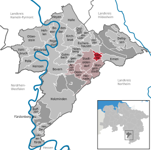
| Location of the municipality of Lenne in the Holzminden district | ||
  |
||

Lenne is a municipality in the district of Holzminden in Lower Saxony (Germany). It belongs to the integrated community of Eschershausen-Stadtoldendorf , which has its administrative seat in the city of Stadtoldendorf .
Geographical location and districts
Lenne lies between the low mountain ranges of Ith in the northeast, Elfas in the east-southeast, Holzberg in the south and Homburgwald in the west; nearby rise the low mountain ranges Vogler in the northwest and Solling in the south-southwest. In addition to the core town of the same name, the districts of Kolonie in the northeast and Linnenplan in the north belong to the municipality of Lenne . The Weser tributary Lenne flows east past the town center and Linnenplan .
history
In 1580 the municipality was mentioned as Sandkuhlen in a document.
During the Nazi era, a labor camp for slave laborers who were forced to work in the mining industry existed northeast of the town at the foot of the Hils with the Lenner camp . Today there is a 4 km long historical educational trail and a memorial in the area .
politics
Municipal council
After the local elections on September 11, 2016 , the municipal council consists of:
- Lenne voter community (WGL): 7 seats
- SPD : 2 seats
mayor
Mayor is Hans-Dieter Steenbock (WGL).

Religions
The Evangelical Lutheran Thomas Church was built 1964–68; it belongs to the parish Wangelnstedt in the parish of Holzminden-Bodenwerder .
The Protestant chapel, built in 1705 and used as the Catholic chapel of St. Anna from 1968 , was closed and is now used as a residential building.
Economy and Infrastructure
traffic
Lenne is located on the state road 583 which meets the federal road 64 in the municipality . The place is also on the Altenbeken – Kreiensen railway line , but the passenger train stop was abandoned in 1987.
Web links
Individual evidence
- ↑ State Office for Statistics Lower Saxony, LSN-Online regional database, Table 12411: Update of the population, as of December 31, 2019 ( help ).
- ↑ Internet presence of the parish Wangelnstedt
Arholzen | Bevern | Bodenwerder | Boffzen | Brevörde | Deensen | Delligsen | Derental | Dielmissen | Buckets | Eschershausen | Fürstenberg | Golmbach | Hall | Caves | Heinade | Heinsen | Heyen | Holenberg | Wood | Holzminden | Kirchbrak | Lauenförde | Lenne | Lüerdissen | Negenborn | Ottenstein | Pegestorf | Pollen | Stadtoldendorf | Vahlbruch | Wangelnstedt
Unregulated areas in the district of Holzminden
Boffzen |
Buckets |
Eschershausen |
Green plan |
Holzminden |
Merxhausen |
Wenzen