
List of waypoints on the Via Militaris

This list indicates the waypoints (cities, settlements, waystations, crossings, rivers or river crossings) along the Via Militaris . The Via Militaris, also Via Diagonalis, rarely and non-Latin also called Via Singidunum, was initially a Roman road connection in the Balkans ( Southeast Europe ), which established the land connection between Europe and Asia Minor . The street fulfilled its strategic role until the late Middle Ages. It was primarily used for troop movements, but was also one of the major transport and cultural routes in Europe.
List of waypoints (cities, waystations, rivers)
| ancient name (and subsidiary forms) | modern name | along the river | roman province |
|---|---|---|---|
| Poetovio or Pectovium | Ptuj in Slovenia | Drau (lat.Dravus) | Pannonia superior |
| Carrodunum (Cardonum) | probably Gradina (Croatia) (10 km east of Virovitica ; in the Virovitica-Podravina County ); or also Šandrovac (Croatia)
Carrodunum |
45 ° 51 '18.54 "N, 17 ° 30' 37.67" E | Pannonia superior |
| Bolentium or Bolentia | (not identified) | Pannonia superior | |
| Mursa | Osijek | Drau (lat.Dravus) | Pannonia inferior |
| Cibalae | Vinkovci | Pannonia inferior | |
| Sirmium (administrative center of the province of Pannonia) | Sremska Mitrovica in Serbia / Vojvodina ( Syrmia landscape ) | Save (Latin Savus); from Sirmium to Naissus Via Militaris is with today's Street of the Imperial identical | Pannonia inferior |
| Taurunum | Zemun | on the right bank of the Danube and on the left bank of the Save | Pannonia inferior |
| Singidunum (legionary camp; strictly speaking, the Via Militaris only begins from Singidunum) | Belgrade (Serbian capital) | at the confluence of the Save (Latin Savus) into the Danube (Latin Ister) | Moesia superior |
| deserta Bulgarorum | a large continuous forest that lay between Belgrade and Niš | the crossing of the forest took eight days | (according to reports from the Middle Ages) |
| Monsaureus (Mons aureus, Aureus Mons, Aureo monte) | Smederevo in Serbia | Danube | Moesia superior |
| Viminatium (a legionary city) | Kostolac ( Požarevac ) | at the Morava confluence with the Danube (Morava = Latin Margus); there the Via Militaris met the Danube Way | Moesia superior |
| from Viminatium the path led upstream along the Morava | |||
| Nonum (Ad Nonum) | Nabrdje (Serbia) (5 km east of Požarevac ) | 44 ° 37 '35.2 "N, 21 ° 15' 0.89" E | |
| Municipium | Kalište (Serbia; Serbian: Калиште; Malo Crniće municipality; Okrug Braničevo ) | 44 ° 30 '52.98 "N, 21 ° 19' 12.96" E | Moesia superior |
| Iovis Pagus (Iouis pago) | Veliki Popovac (or Veliko Laole) | 44 ° 37 '7.56 "N, 21 ° 10' 58.12" E | |
| Idimum (Idimo) | 24–26 km north of the next station: Horreum Margi (this corresponds approximately to the region of the city of Batočina ); at the village of Medveda on the Resava (river) | there is a station of the same name in Medveđa in southern Serbia | Moesia superior |
| Octavum | Dražmirovac | 44 ° 3 '21 "N, 21 ° 20' 54" E | Moesia superior |
| Horreum Margi (Horrea Margi, Orea Margi) | Ćuprija | Morava (lat.Margus) | Moesia superior |
| Sarmatae (mutatio sarmatorum) | Gornji Vidovac? | Moesia superior | |
| Cametae (Cametas) | Ražanj (Ражањ) ( Okrug Nišava ) | 43 ° 40 '28.45 "N, 21 ° 32' 57.41" E | Moesia superior |
| Praesidium Dasmini (Praes. Dasmini, Presidio Dasmini, Dasmiani; Greek: Δούσμανες = Dasmanis) | Novi Bracin (okrug Nisava) | Moesia superior | |
| Praesidium Pompei (Praes.Pompei, Pompegis) | Rutevac (Municipality of Aleksinac ); according to other information Bovan (Aleksinac) or Bovan (municipality Kruševac ) | 43 ° 34 '50.70 "N, 21 ° 37' 7.94" E | Moesia superior |
| Grampianae (Grampiana, Crambianis) | Draževac (Aleksinac) (Municipality of Aleksinac ); or Sokobanja- Lipovac | 43 ° 27 '3.12 "N, 21 ° 47' 35.42" E (Draževac) | Moesia superior |
| Naissus | Niš | on the Nišava ; In Naissus, the Via Trajana separated from the Via Militaris | Moesia superior |
| Mediana | eastern suburb of Niš (Brzi Brod - a district in the Medijana district) | Moesia superior | |
| mutatio radices (mutatio redicibus) | Moesia superior | ||
| mutatio Ulmo (Ulmus) | Ostrovica (Niška Banja) - ( Niška Banja is a district of Niš. The place is spatially separated about eight kilometers east of the city center of Niš.) | Moesia superior | |
| mutatio Remesiana (Romessiana, Remisiana, Romansiana) | Bela Palanka | Moesia superior | |
| mutatio Latina | Telovac ??? | the last place where Latin was spoken according to the toponyms, all places further east were in Greek | |
| mutatio Turres (Turribus) | at Pirot | Moesia superior | |
| Meldia | Duplication? | Thrace | |
| mutatio translitus (translitae) | at Dimitrovgrad | Crossing over the Nišava | Tracia |
| in the valley of the Nišava upstream | |||
| mutatio Ballanstra | near Kalotina (Bulgaria) | Nišava | Tracia |
| Meldia (Meldijs, Meldis) | Dragoman | Duplication? | |
| mutatio Scretisca (the first mutatio on Via Militaris northwest of Serdica) | on the southern city limits of Kostinbrod | ||
| Serdica (Sertica) | Sofia (Bulgarian capital) | Iskar (Latin Oescus) | Thrace |
| Volujak (Bulgarian Волуяк) | |||
| Combusticia | |||
| Extuomne | Kaciljane | ||
| Burgaraca | Lesnowo | ||
| mansio Bugaraca (Bugaraka, Bagaraca, Bugaracenses, Buragara) | near Lesnowo (approx. 20 - 30 Roman miles from Serdica) | ||
| Ichtiman level (the level of Ichtiman ) | |||
| mutatio Sparata (Sarto ?, Sparthon) | Wakarel | ||
| mutatio Helice (Hilica, Iliga, Egirca) (between Sparata and the Haemuspass - in the Ichtiman basin) | Ichtiman | ||
| Egerica (Egirca) (order? - possibly higher or lower) | Mirowo | ||
| mutatio Soneium (Succi, Succorum angustiae, Stoponion = Щипон / Schtipon) | Trajantor (Succorum claustra = Succi pass) at today's Kapudžik | ||
| Pons Ucasi | |||
| Bona Mansio | |||
| Tegulitsium ?? Vetrinon ?? Vetren (4 km north of today's Wetren) | Wetren | ||
| Septemwri | |||
| along the Mariza (lat. Hebros) in the Mariza valley through Thrace | Pazardzhik (founded in 1485) | Mariza (Latin Hebrus; Greek Evros) | |
| Lissae (Lissas) | |||
| Alusore | Bosulja | ||
| Zyrmae (Zyrmis, Zirmis) | Junazite | ||
| Besapara | Sinitowo | ||
| Kapisturia | |||
| Tugugerum (Tugurium?) | Joakim Gruewo | ||
| Philippolis (Trimontium, Phinipopolis, civ. Filopopuli) | Plovdiv | Mariza (Latin Hebrus River) | Thrace |
| Beripara? | |||
| Isgipera | |||
| Sernota (Syrmae?) | Manole | ||
| Paremvole | Belozem | ||
| Ranilum | Orisowo | ||
| Cellae (Cillis) | Cherna Gora | ||
| Castra rubra (2nd century AD; previously a mutatio) | 8 km northeast of Charmanli and 5 km west of Izvorovo | the neighboring mansio was Pale, west of Charmanli (probably between the villages of Ovcharowo and Tjanewo) | |
| Braniza (a village in Haskovo Oblast) | |||
| Castozorbra | Izvorovo (village) (more precisely: west of the village) ( Chaskowo Oblast ) | the border station between the provinces of Thrace and Haemimontus | |
| Arsus | |||
| mutatio Carassura ( Karasura , Greek Καράσθυρα) | Rupkite | ||
| Pizus (Pizo, Opizo) | Dimitriewo | ||
| Tulei? | |||
| Arzus (Arzum, Arso) | Kalugerowo | ||
| Palae | |||
| Castra rubra (Castris rubris, castozobra) | Duplication? (there is only one Castra Rubra in Bulgaria guaranteed) | ||
| Subzupara? | |||
| Rhamae | |||
| Burdipta (Burdista) | Momkowo (near Swilengrad ) | ||
| Constantia ??? | |||
| Hadrianopolis (civitas Hadrianapoli) or Adrianopolis or Orestia | Edirne | In Edirne, a side street of the Via Egnatia met the Via Militaris (this is exactly where the Battle of Adrianople (378) took place) | |
| Dapabae (Daphabae) | |||
| Ostudizus (Hostizo, Ostudizo) | Havsa | ||
| Tarpodizus | |||
| Burtudizus (Burtizo, Bulgarophygon) | Babaeski | ||
| Urisium? | |||
| Bergulae (Arcadiopolis) | Lüleburgaz | ||
| Narcus | |||
| Drusipara (Drysiporo) | Karištiran | ||
| Tipsum | |||
| Tzurullus (Syrallo, Izirallo, Tzurulum, Syrallum) | Çorlu | ||
| Beodizo | |||
| Perinthus (Perinthos, Herakleia) | Marmara Ereğlisi | ||
| Selymbria | Silivri | ||
| Regio | Küçükçekmece | ||
| Byzantion ( Constantinople ) | Istanbul |
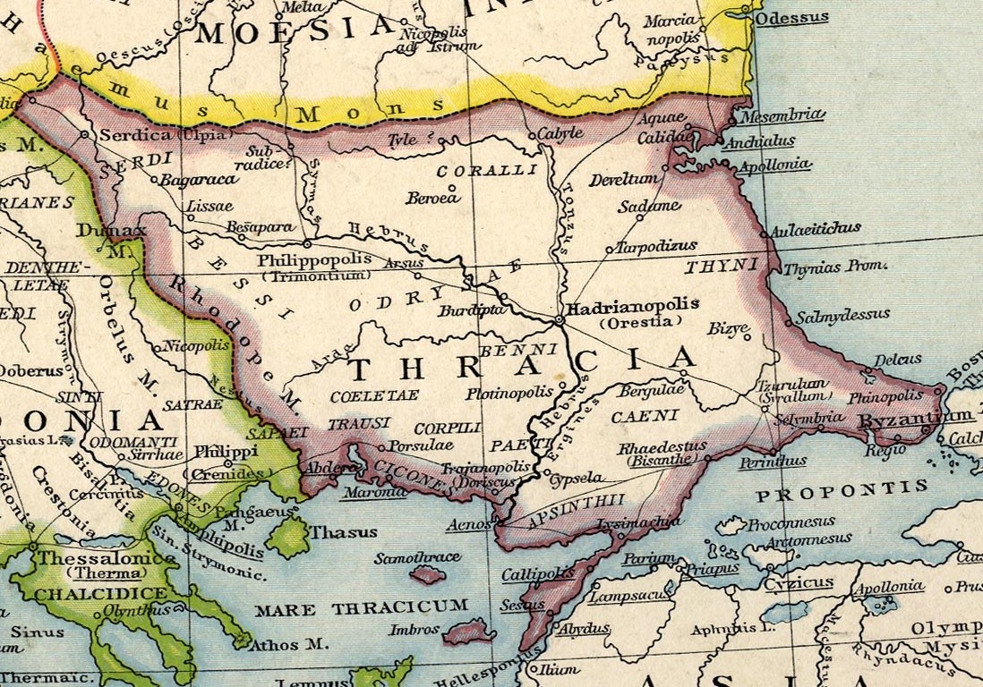
Historical hand atlas by Gustav Droysen
,_Droysens_Historical_Atlas,_1886.jpg)
The General Historical Handbook by Gustav Droysen from 1886, map sheet "The lower Danube countries in Roman times" , shows the following settlements along the Via Militaris (from northwest to southeast):
- Poetovio, Jovia, Carrodunum, Bolentium, Mursa, Cibalae, Sirmium, Taurunum, Singidunum, Monsaureus, Viminatium, Municipium, Idimum, Horreum Margi, Praes. Dasmini, Praes. Pompei, Naïssus, Remesiana, Turres, Meldia, Serdica (ulpia), Bagaraca, Lissae, Besapara, Philippolis (Trimontium), Arsus, Hadrianapolis (Orestia), Bergulae, Tzurulum (Syrallum), Selymbria, Regio, Byzantium.
Itinerarium provinciarum Antonini Augusti
The Antonini Itinerarium from the beginning of the 3rd century AD lists the following places without using the term Via Militaris or Via Diagonalis:
- Mursa civitas, Cibalas civitas, Ulmos vicus, Sirmi civitas, Bassianis civitas, Tannino classis, Singiduno castra (today Belgrade), Aureo monte, (from Aureo monte Vinceia, Margo, et leg. VIII, inde Viminacio), Viminacio (today Kostolac) , Municipio, Idimo, Horreo Margi, Pompeis, Naisso (today Niš), Remisiana, Turribus, Meldia, Serdica (today Sofia), Bagaraca, Helice, Lissas, Bessapara, Philippopoli (today Plowdiw), Cillis, Opizo, Arso, Subzupara, Burdipta, Hadrianopoli (today Edrne), Ostudizo, Burtudizo, Bergule, Drizipara, Izirallo, Heraclia, Cenofrurio, Melantiada, Byzantio [qui et Constantinopoli] (today Istanbul).
Tabula Peutingeriana
Waypoints from Singiduno (Belgrade) to Constantinople according to Tabula Peutingeriana :
- Singiduno, Tricornio, Monte aureo, Margum fl. (River), Viminatio, Municipio, Iovis pago, Idimo, Horrea Margi, Presidio pompei, Gramrianis, Naisso, Romesiana, Turribus, Meldiis, Sertica (= Serdica), Sarto, Egirka, Zyrmis , Bessapora, Ranilum , Pizo, Arzum, Castris rubris , Burdenis, Hadrianopoli, Hostizo, Burtizo, Bergule, Drysiporo, Syrallo, Perintos, Cenopurio, Ad statuas, Melentiana, Constantinopolis.
Itinerarium Burdigalense
Waypoints from Mursa to Constantinople according to the Itinerarium Burdigalense (333–334):
- ciuitas mursa, mutatio leutuoano, ciuitas cibalis, mutatio caelena, mansio vlmo, mutatio spaneta, mutatio vedulia, ciuitas Sirmium (Fit from Aquileia, Sirmium usque milia ccccxii, mansiones xvii, mutationes xxxviii - Total of Aquileia to Sirmium 412 miles, 17 mansione , 39 mutationes), Mutatio fossis, ciuitas bassianis, mutatio nouiciani, mutatio altina, ciuitas singiduno (now Belgrade), (Fines pannoniae et misiae - border between Pannonia and Moesia), Mutatio ad sextum, mutatio tricornia castra, mutatio ad sextum ciuitas aureo monte, mutatio vingeio, ciuitas margo, ciuitas viminacio, Mutatio ad nonumi, mansio munecipio, mutatio iouis pago, mutatio bao, mansio idomo, mutatio ad octauum, mansio oromago, (Finis myssiae), Moesiene - border between Moesiae and Asia Mutatio sarmatorum, mutatio caminitas, mansio ipompeis, mutatio rampiana, ciuitas naisso (today Niš), mutatio redicibus, mutatio vlmo, mansio romansiana, mutatio latina, mansio turribus, mutatio translitis, mutatio ballanstra, mansio meldia, mutatio scretisca, ciuitas serdica (today Sofia), (Fit a sirmium serdica usque milia cccxiiii, mutationes xxiiii, mansiones xiii - total from Sirmium to Sofia 314 miles, 24 mutationes, 13 mansiones), mutatio extuomne buragara, mutatio sparata, mansio hilica, mutatio soneio, (Fines daciae et traciae - border between Dacia and Thracia), Mutatio ponte vcasi, mansio bona mansio, mutatio alusore, mansio basapare, mutatio tugugero, ciuitas mutio filio sernota), today , mutatio paramuole, mansio cillio, mutatio carassura , mansio arzo, mutatio palae, mansio castozobra, mutatio rhamis, mansio burdista, mutatio daphabae, mansio nicae, mutatio tarpodizo, mutatio vrisio, mansio mutizup, mutatio virgoles, mansio virgoles tunorullo, mutatio beodizo, ciuitas heraclea, mutatio baunne, mansio salambria, mutatio callum, mansio atyra, mansio regio, Ciuitas constantinopoli (today Istanbul), (Fit a serdica constantinopo li milia ccccxiii, mutationes xii, mansiones xx - in total from Sofia to Constantinople 413 miles, 12 mutationes, 20 mansiones).
Ravenna cosmography
The anonymous Ravenna cosmography by the geographer of Ravenna from the year 700 also lists some places that were on the Via Militaris. Fabrizio Vanni contrasts them with the place names in the Tabula Peutingeriana (the place names in Ravenna cosmography in brackets):
- Singiduno, Tricornio, Monte aureo, Margum fl., Viminatio, Municipio, Iovis pago (Pago), Idimo, Horrea Margi (Orea Margi), Presidio Dasmini (Dasmiani), Presidio Pompei (PoVpeg is), Gramrianis (Crambianis), Naisso ( Naison), Romesiana (Romessiana), Turribus (Turribus), Meldiis (Meldis), Sertica, Sarto (Sparthon), Egirca (Egerica), Zyrmis (Zirmis), Philipopolis, Ranilum (Ranilum), Pizo, Arzum, Castris Rubris, Burdenis , Hadrianopoli, Hostizo, Burtizo (Burtizon), Bergule (Bergule), Drysiporo (Drusipara), Syrallo (Surallon), Perintus, Ad statuas (Statuas), Melintiana (Melantiada), Regio, Constantinopolis.
Travel literature
There are numerous itineraries in which the Via Militaris is reported.
With Hungary's conversion to Christianity at the end of the 10th century, an increasing number of high-ranking pilgrims from the West, such as German and French bishops, traveled to Jerusalem along this road from the beginning of the 11th century. Later, imperial embassies traveled more frequently to the Ottoman Empire , and their companions occasionally wrote travel reports.
In 1026, Count Wilhelm von Angoulême was one of the first to reopen the overland route across the Balkans to Jerusalem, as Ademar von Chabannes and the Gesta episcoporum et comitum Engolismensium reported, adding that no one had dared to take this road until then (“quia novella adhuc christianitas per Ungariam et Sclavoniam erat ”). Among other things, four German bishops from Bamberg ( Gunther von Bamberg , accompanied by the poet Ezzo von Bamberg ), Mainz ( Siegfried von Mainz ), Regensburg ( Otto von Riedenburg ) and Utrecht ( Wilhelm I. von Utrecht ) traveled in 1064 together with 7,000 pilgrims Route to the Holy Land.
Popovic lists the following travel reports: Itinerarium de Brugis ( Bruges Itinerar ; around 1380), Peter Sparnau and Ulrich von Tennstaedt (1385/86), Johannes Schiltberger (1396–1427), Bertrandon de la Broquière (1432/33), Pero Tafur ( 1435–1439), Ciriaco de 'Pizzicolli Anconitano (1444/45), Konstantin Mihailović from Ostrovica (1455–1463), Jacopo de Promontorio de Campis (1456), Giovanni Maria Angiolello (1470–1483), Martino Segono (1480), Bernardo Michelozzi and Bonsignore Bonsignori (1497/98), Arnold von Harff (1496–1499), Felix Petančić (1513), campaign diary of the first Hungarian campaign Suleyman I (1521), campaign diary of the second Hungarian campaign Suleyman I (1526), Triscano Savregnano (after 1528), diary of Suleyman I's fourth campaign to Vienna (1529), Benedikt Kuripešič (1530/31), diary of Suleyman I's fifth campaign against Emperor Charles V (1532), Benedikt Kuripesic : Wegraysz Keyserlicher Mayestat Legation in the 32nd year, sent to the Turk, how, and what ge stalt, she in, and in turn out, come is (1532), Corneille Duplicius de Schepper (1533), Benedetto Ramberti (1534), diary of Suleyman I's seventh campaign against Awlona (1537), Paulus Rubigallus (1540), Hieronymus Laski (1540/41), Nasuhü's-Silahi - called Matrakçı (1543), Hugone Favolio (1545/46), Jean Chesneau (1547–1555), Catharin Zen (1550), Hans Dernschwam (1553–1555), Antun Vrančić (1553 ), Ogier Ghislain de Busbecq (1554/55), Melchior von Seydlitz (1556–1559), Erasm Otwinowski (1557), Gaspare Erizzo (1558), Viaggio per terra da Dolcigno a Costantinopoli from le miglia italiane, et altri avvertimenti, e grade. (1558), Marino Cavalli (1558–1560), Jakob von Betzek (1564/65) Michael von Saurau (1567), Antun Vrančić (1567), Karel Rijm (1570–1574), Salomon Schweigger (1577–1581), Levinus Rijm (1583) and Reinhold Lubenau (1587/88).
Levinus Rijm
Levinus Rijm describes a trip from Brussels to Stambul (Istanbul), which he undertook from July 1583 to February 1584 as the companion of several nobles. Levinus Rijm described the Via Traiana as a connection between Budapest and Constantinople in his diary. In the Middle Ages, the military road did not begin and end in Belgrade, but instead extended to Budapest. The route was based on the ancient Roman road layout. The stops on the road from Belgrade to Budapest were in 1584: Belgrade, Vukovar , Osijek , Mohács , Tolna , Paks , Dunaföldvá and Budapest.
Individual evidence
- ↑ Ancient Toponymy -Pannonia: Carrodunum
- ^ Johann Georg Theodor Grasse : Orbis Latinus (1909); ORBIS LATINUS ; at google books
- ^ Tabula Europa IIII, in Germania Magna, Seb. Münster 1555, (today Krakow) on the Vistula River, south of Calisia (Kalisch) ( Memento of the original from December 2, 2013 in the Internet Archive ) Info: The archive link was automatically inserted and not yet checked. Please check the original and archive link according to the instructions and then remove this notice.
- ↑ Ancient Toponymy -Pannonia: Bolentium
- ↑ a b c Fabrizio Vanni (Florence): Overland Balkan Routes in the Middle Ages (PDF; 334 kB)
- ↑ Drumul Traciei ( Memento of the original from May 26, 2011 in the Internet Archive ) Info: The archive link was inserted automatically and has not yet been checked. Please check the original and archive link according to the instructions and then remove this notice.
- ^ Hanswilhelm Haefs: The golden empire of the Pamir-Bulgarians on the Danube and Wardar + Skythen-Gold (p. 44) Books on Demand GmbH Norderstedt 2009; ISBN 978-3-8334-2340-6 ; (according to other information - list of mayors of Sofia - both paths crossed in Sofia)
- ↑ Michael Wendel: Karasura. The transport links in the early Byzantine period (4th-8th century AD) (excerpt from google-books )
- ↑ Archived copy ( memento of the original from January 23, 2011 in the Internet Archive ) Info: The archive link was inserted automatically and has not yet been checked. Please check the original and archive link according to the instructions and then remove this notice. "Град Пазарджик е основан през първата четвърт на ХV век и възниква като търговско средище на международния път Сингидунум , свързващ Европа с Мала Азия." - German "The city of Pazardzhik was founded in the first quarter of the 15th century and emerged as a trade broker on the international Singundium route, which connected Europe with Asia Minor."
- ↑ map sheet (can be enlarged and moved)
- ↑ Itinerarium Antonini: (Balkanic roads) ( Memento of the original from November 28, 2006 in the Internet Archive ) Info: The archive link was inserted automatically and has not yet been checked. Please check the original and archive link according to the instructions and then remove this notice.
- ↑ (Editor) Иван Дуйчев, Михаил Войнов, Борислав Примов, Велизар Велков: Латински извори за българ искатааи . Fontes Historiae Bulgaricae II Fontes Latini Historiae Bulgaricae I. Издание на Българската Академия на Науката, Институт за българска история, София 1958 (Editors: Ivan Dujtschew, Michil Wojnow, Borislav Primow and Welisar Welkow : Latin sources for Bulgarian history Volume 2, Bulgarian Academy of Sciences, Institute for Bulgarian History, Sofia 1958) (p. 14 ff.)
- ↑ ITINERARIVM A BVRDIGALA HIERVSALEM VSQVE ET AB HERACLEA PER AVLONAM ET PER VRBEM ROMAM MEDIOLANVM VSQVE SIC ( Memento of the original from November 14, 2017 in the Internet Archive ) Info: The archive link has been inserted automatically and has not yet been checked. Please check the original and archive link according to the instructions and then remove this notice. (THE ANONYMOUS PILGRIM OF BORDEAUX - LATIN TEXT); Title page and map ( memento of the original dated June 4, 2011 in the Internet Archive ) Info: The archive link was inserted automatically and has not yet been checked. Please check the original and archive link according to the instructions and then remove this notice. ; Translations of the Latin place names ( Memento of the original from June 4, 2011 in the Internet Archive ) Info: The archive link was inserted automatically and has not yet been checked. Please check the original and archive link according to the instructions and then remove this notice.
- ↑ Itinéraire de Bordeaux à Jérusalem (French)
- ^ Otto Cuntz and Gerhard Wirth : Itineraria Antonini Augusti et Burdigalense.
- ↑ Mihailo Popović: FROM BUDAPEST TO ISTANBUL. The Via Traiana as reflected in travel literature from the 14th to 16th centuries. Vienna, PDF
Remarks
- ↑ In the Geographike Hyphegesis by Claudius Ptolemäus (II, 11,29): Carrodunum (Καρρόδουνον), this place is now also localized in Krakow ( Carrodunum ); according to the Itinerarium Burdigalense : mutatio cardono; Identical name with Carrodunum (Germania) - between Augsburg and Passau; Carro-dunum is Celtic for chariot castle
- ↑ If Vidovac in the Opština Knjaževac is meant, this seems unlikely, since it is off the road, about 40 km east of Niš .
- ↑ In Wolujuk there is a branching off of a side road to Pautalia ( Kyustendil ) - a Roman pillar erected there bears the inscription: Have a good trip! For the health, salvation and victory of our Lord Mark Antonius Gordian ... the city of Pautalia has put up this pillar with the very best of feelings.
Web links
- Латински Извори за Българскате Изтория (Sofia, 1958; Latin sources for Bulgarian history)