
Kufstein – Innsbruck railway line
| Kufstein border – Innsbruck main station | |||||||||||||||||||||||||||||||||||||||||||||||||||||||||||||||||||||||||||||||||||||||||||||||||||||||||||||||||||||||||||||||||||||||||||||||||||||||||||||||||||||||||||||||||||||||||||||||||||||||||||||||||||||||||||||||||||||||||||||||||||||||||||||||||||||||||||||||||||||||||||||||||||||||||||||||||||||||||||||||||||||||||||||||||||||||||||||||||||||||||||||||||||||||||||||
|---|---|---|---|---|---|---|---|---|---|---|---|---|---|---|---|---|---|---|---|---|---|---|---|---|---|---|---|---|---|---|---|---|---|---|---|---|---|---|---|---|---|---|---|---|---|---|---|---|---|---|---|---|---|---|---|---|---|---|---|---|---|---|---|---|---|---|---|---|---|---|---|---|---|---|---|---|---|---|---|---|---|---|---|---|---|---|---|---|---|---|---|---|---|---|---|---|---|---|---|---|---|---|---|---|---|---|---|---|---|---|---|---|---|---|---|---|---|---|---|---|---|---|---|---|---|---|---|---|---|---|---|---|---|---|---|---|---|---|---|---|---|---|---|---|---|---|---|---|---|---|---|---|---|---|---|---|---|---|---|---|---|---|---|---|---|---|---|---|---|---|---|---|---|---|---|---|---|---|---|---|---|---|---|---|---|---|---|---|---|---|---|---|---|---|---|---|---|---|---|---|---|---|---|---|---|---|---|---|---|---|---|---|---|---|---|---|---|---|---|---|---|---|---|---|---|---|---|---|---|---|---|---|---|---|---|---|---|---|---|---|---|---|---|---|---|---|---|---|---|---|---|---|---|---|---|---|---|---|---|---|---|---|---|---|---|---|---|---|---|---|---|---|---|---|---|---|---|---|---|---|---|---|---|---|---|---|---|---|---|---|---|---|---|---|---|---|---|---|---|---|---|---|---|---|---|---|---|---|---|---|---|---|---|---|---|---|---|---|---|---|---|---|---|---|---|---|---|---|---|---|---|---|---|---|---|---|---|---|---|---|---|---|---|---|---|---|---|---|---|---|---|---|---|---|---|---|---|---|---|---|---|---|---|---|---|---|---|---|---|---|---|---|---|---|---|---|---|---|---|---|---|
 A Railjet near Jenbach.
| |||||||||||||||||||||||||||||||||||||||||||||||||||||||||||||||||||||||||||||||||||||||||||||||||||||||||||||||||||||||||||||||||||||||||||||||||||||||||||||||||||||||||||||||||||||||||||||||||||||||||||||||||||||||||||||||||||||||||||||||||||||||||||||||||||||||||||||||||||||||||||||||||||||||||||||||||||||||||||||||||||||||||||||||||||||||||||||||||||||||||||||||||||||||||||||
 | |||||||||||||||||||||||||||||||||||||||||||||||||||||||||||||||||||||||||||||||||||||||||||||||||||||||||||||||||||||||||||||||||||||||||||||||||||||||||||||||||||||||||||||||||||||||||||||||||||||||||||||||||||||||||||||||||||||||||||||||||||||||||||||||||||||||||||||||||||||||||||||||||||||||||||||||||||||||||||||||||||||||||||||||||||||||||||||||||||||||||||||||||||||||||||||
| Route number (ÖBB) : | 302 01 (Kufstein border – Wörgl) 101 04 (Wörgl – Innsbruck) 101 15 (Wörgl – Wörgl Kundl) |
||||||||||||||||||||||||||||||||||||||||||||||||||||||||||||||||||||||||||||||||||||||||||||||||||||||||||||||||||||||||||||||||||||||||||||||||||||||||||||||||||||||||||||||||||||||||||||||||||||||||||||||||||||||||||||||||||||||||||||||||||||||||||||||||||||||||||||||||||||||||||||||||||||||||||||||||||||||||||||||||||||||||||||||||||||||||||||||||||||||||||||||||||||||||||||
| Course book route (ÖBB) : | 300 (Salzburg – Brennero / Brenner) 301 (Jenbach – Telfs-Pfaffenhofen / Steinach in Tirol) |
||||||||||||||||||||||||||||||||||||||||||||||||||||||||||||||||||||||||||||||||||||||||||||||||||||||||||||||||||||||||||||||||||||||||||||||||||||||||||||||||||||||||||||||||||||||||||||||||||||||||||||||||||||||||||||||||||||||||||||||||||||||||||||||||||||||||||||||||||||||||||||||||||||||||||||||||||||||||||||||||||||||||||||||||||||||||||||||||||||||||||||||||||||||||||||
| Route length: | 74.921 km | ||||||||||||||||||||||||||||||||||||||||||||||||||||||||||||||||||||||||||||||||||||||||||||||||||||||||||||||||||||||||||||||||||||||||||||||||||||||||||||||||||||||||||||||||||||||||||||||||||||||||||||||||||||||||||||||||||||||||||||||||||||||||||||||||||||||||||||||||||||||||||||||||||||||||||||||||||||||||||||||||||||||||||||||||||||||||||||||||||||||||||||||||||||||||||||
| Gauge : | 1435 mm ( standard gauge ) | ||||||||||||||||||||||||||||||||||||||||||||||||||||||||||||||||||||||||||||||||||||||||||||||||||||||||||||||||||||||||||||||||||||||||||||||||||||||||||||||||||||||||||||||||||||||||||||||||||||||||||||||||||||||||||||||||||||||||||||||||||||||||||||||||||||||||||||||||||||||||||||||||||||||||||||||||||||||||||||||||||||||||||||||||||||||||||||||||||||||||||||||||||||||||||||
| Network category : | A. | ||||||||||||||||||||||||||||||||||||||||||||||||||||||||||||||||||||||||||||||||||||||||||||||||||||||||||||||||||||||||||||||||||||||||||||||||||||||||||||||||||||||||||||||||||||||||||||||||||||||||||||||||||||||||||||||||||||||||||||||||||||||||||||||||||||||||||||||||||||||||||||||||||||||||||||||||||||||||||||||||||||||||||||||||||||||||||||||||||||||||||||||||||||||||||||
| Power system : | 15 kV 16.7 Hz ~ | ||||||||||||||||||||||||||||||||||||||||||||||||||||||||||||||||||||||||||||||||||||||||||||||||||||||||||||||||||||||||||||||||||||||||||||||||||||||||||||||||||||||||||||||||||||||||||||||||||||||||||||||||||||||||||||||||||||||||||||||||||||||||||||||||||||||||||||||||||||||||||||||||||||||||||||||||||||||||||||||||||||||||||||||||||||||||||||||||||||||||||||||||||||||||||||
| Maximum slope : | 27 ‰ | ||||||||||||||||||||||||||||||||||||||||||||||||||||||||||||||||||||||||||||||||||||||||||||||||||||||||||||||||||||||||||||||||||||||||||||||||||||||||||||||||||||||||||||||||||||||||||||||||||||||||||||||||||||||||||||||||||||||||||||||||||||||||||||||||||||||||||||||||||||||||||||||||||||||||||||||||||||||||||||||||||||||||||||||||||||||||||||||||||||||||||||||||||||||||||||
| Minimum radius : | 250 m | ||||||||||||||||||||||||||||||||||||||||||||||||||||||||||||||||||||||||||||||||||||||||||||||||||||||||||||||||||||||||||||||||||||||||||||||||||||||||||||||||||||||||||||||||||||||||||||||||||||||||||||||||||||||||||||||||||||||||||||||||||||||||||||||||||||||||||||||||||||||||||||||||||||||||||||||||||||||||||||||||||||||||||||||||||||||||||||||||||||||||||||||||||||||||||||
| Top speed: | 160 km / h | ||||||||||||||||||||||||||||||||||||||||||||||||||||||||||||||||||||||||||||||||||||||||||||||||||||||||||||||||||||||||||||||||||||||||||||||||||||||||||||||||||||||||||||||||||||||||||||||||||||||||||||||||||||||||||||||||||||||||||||||||||||||||||||||||||||||||||||||||||||||||||||||||||||||||||||||||||||||||||||||||||||||||||||||||||||||||||||||||||||||||||||||||||||||||||||
| Dual track : | Kufstein border – Innsbruck main station | ||||||||||||||||||||||||||||||||||||||||||||||||||||||||||||||||||||||||||||||||||||||||||||||||||||||||||||||||||||||||||||||||||||||||||||||||||||||||||||||||||||||||||||||||||||||||||||||||||||||||||||||||||||||||||||||||||||||||||||||||||||||||||||||||||||||||||||||||||||||||||||||||||||||||||||||||||||||||||||||||||||||||||||||||||||||||||||||||||||||||||||||||||||||||||||
|
|||||||||||||||||||||||||||||||||||||||||||||||||||||||||||||||||||||||||||||||||||||||||||||||||||||||||||||||||||||||||||||||||||||||||||||||||||||||||||||||||||||||||||||||||||||||||||||||||||||||||||||||||||||||||||||||||||||||||||||||||||||||||||||||||||||||||||||||||||||||||||||||||||||||||||||||||||||||||||||||||||||||||||||||||||||||||||||||||||||||||||||||||||||||||||||
The Kufstein – Innsbruck railway (also known as the Lower Inn Valley Railway ) is a double-track, electrified main railway in Austria , which was originally built as the Imperial and Royal North Tyrolean State Railway . It begins at the state border near Kufstein and continues the route from Rosenheim and leads in Tyrol along the Inn to Innsbruck . The line is part of the European TEN axis Berlin-Palermo . The owner and operator is ÖBB Infra .
history
The line was opened as the first western Austrian railway line on November 24, 1858, after its construction had been ordered by Emperor Franz Joseph I in 1853 . The 150th anniversary was celebrated in Wörgl in 2008 .
In the first Austrian republic, the line was the responsibility of the Innsbruck Federal Railway Directorate . After Austria was annexed in 1938, it operated briefly as the Innsbruck Railway Directorate before it was dissolved on July 15, 1938. The route was subordinated to the Reichsbahndirektion Munich . After 1945 the ÖBB was re-established, the management structure from the time before 1938 was re-established, including the Federal Railway Directorate Innsbruck.
Expansion measures

With a view to increasing the capacity of the line and in anticipation of the construction of the Brenner Base Tunnel , a new high-performance line was built between the Kundl 1 junction and the rebuilt Fritzens - Wattens 1 junction (near Baumkirchen ), which has been used by trains as scheduled since December 9, 2012 . This runs in large parts in tunnels so that the Inn Valley, which is already heavily polluted by noise, is not affected even more. The upgraded route is designed for mixed traffic up to 220 km / h. The second section of the expansion program for the Lower Inn Valley Railway Brannenburg - Schaftenau --Kundl / Radfeld is in the planning phase.
At the end of 2009, the route-finding process between Schaftenau and Kundl, which had been running since 2005, was completed. On the basis of a feasibility study from 1993, 17 variants north and south of the Inn valley and in the valley floor were explored. After a pre-selection in 2008, four options were examined in depth. The chosen route runs in a westerly direction before Kundl in a ten kilometer long tunnel and a chain of further troughs and tunnels. At Schaftenau (south of Kufstein), the line is to be linked to the existing line.
ETCS Level 2 went into operation between Wörgl and Innsbruck in 2012 .

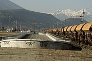
Start of the railway line at km 0
Integration of Baumkirchen


Web links
- ÖBB information about the "New Lower Inn Valley Railway"
literature
- Martin Pellizzari: Brenner railway axis: North access route 1996–2012: Documentation, experiences . 1st edition. Haymon, Innsbruck 2012, ISBN 978-3-7099-7034-8 .
Individual evidence
- ↑ Greater Innsbruck: Six new stops - tirol.ORF.at. In: tirol.orf.at. January 15, 2014, accessed March 28, 2016 .
-
^ "Milestone" for ÖBB: S-Bahn stop Innsbruck-Messe fixed. In: tt.com. May 16, 2019, accessed May 18, 2019 . Austria: Starting shot for the new Innsbruck Messe stop. In: lok-report.de. April 30, 2020, accessed May 1, 2020 .
- ↑ Deutsche Reichsbahn-Gesellschaft (Ed.): Official Gazette of the Reichsbahndirektion Mainz of August 6, 1938, No. 36. Announcement No. 488, p. 213.
- ↑ Report route selection completed . In: Der Eisenbahningenieur , Volume 64, November 2009 issue, p. 65.
- ^ Roman DOWN, Gerhard Fritze: The EU test of the GSM-R network of the ÖBB-Infrastruktur AG according to the TSI ZZS . In: signal + wire . tape 108 , no. 6 , 2015, ISSN 0037-4997 , p. 40-47 .
Railways (standard gauge), in operation: Kufstein – Innsbruck | Innsbruck – Verona | Innsbruck – Bludenz | Innsbruck – Garmisch-Partenkirchen | Garmisch-Partenkirchen – Reutte – Kempten | Innsbruck bypass | not carried out: Landeck – Mals | under construction / planning: Grafing – Innsbruck (HLS) | Brenner base tunnel
Railways (narrow gauge), in operation: Innsbruck – Fulpmes | Innsbruck – Igls (today part of the Innsbruck tram) | Jenbach – Mayrhofen (Zillertal Railway) | Kiefersfelden – Wachtl | set: Kufstein – Schwoich
Trams, in operation: Innsbruck tram | (Narrow gauge), discontinued: Innsbruck – Hall iT
Cogwheel and funicular railways: Jenbach – Seespitz | Hungerburgbahn | Old Hungerburgbahn | Kaiser Maximilian Panorama Railway | Olympic track
Berlin – Bitterfeld – Halle | Bitterfeld – Leipzig | Halle / Leipzig – Erfurt | Erfurt – Nuremberg | Nuremberg – Munich | Munich – Rosenheim | Rosenheim – Kufstein | Kufstein – Wörgl | Wörgl – Innsbruck | Innsbruck bypass | Brenner base tunnel | Franzensfeste – Verona | Milan / Verona – Bologna | Bologna – Florence | Florence – Rome | Rome – Naples | Naples – Salerno | Salerno – Reggio di Calabria | Bridge over the Strait of Messina | Messina – Fiumetorto | Fiumetorto – Palermo
Coordinates: 47 ° 15 '47.8 " N , 11 ° 24' 3.6" E