Pays de la Loire
| Pays de la Loire | |
|---|---|

|

|
| Basic data | |
| Country |
|
| prefecture | Nantes |
| President of the Regional Council | Bruno Retailleau ( LR ) |
| population | 3,757,600 (January 1, 2017) |
| Population density | 116.8 inhabitants per km² |
| surface | 32,179 km² |
| Departments | 5 |
| Arrondissements | 16 |
| Community associations | 72 |
| Cantons | 192 |
| Communities | 1,238 |
| ISO-3166-2 code | FR-PDL |
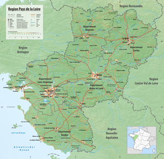
 Relief map of the Pays de la Loire region |
|
The Pays de la Loire [ peidlaˈlwaːʀ ] (German " Land of the Loire") are a region in western France located at the mouth of the Loire . It consists of the departments of Loire-Atlantique , Maine-et-Loire , Mayenne , Sarthe and Vendée . The region has an area of 32,082 km² and a population of 3,757,600 (as of January 1, 2017). The capital of the region is Nantes , other important cities are Angers and Le Mans .
coat of arms
Description: The coat of arms is split and shows six rows of scattered golden lilies in the front in blue, surrounded by a red border with a silver lion in the upper corner and in the back in silver in the same type of ermine in black. The blue board is inside in a wave cut . Above everything is the red sign of the Vendée uprising .
history
The region consists of the historic landscapes of Maine , Anjou , Le Perche and Poitou as well as part of the former province of Brittany . It was created in 1955 with the establishment of the regions in France. In 1972 the region received the status of an établissement public under the direction of a regional prefect. The decentralization laws of 1982 gave the regions the status of collectivités territoriales ( territorial authorities ), which until then had only been enjoyed by the municipalities and the départements . In 1986 the regional councils were directly elected for the first time. Since then, the region's powers vis-à-vis the central government in Paris have been gradually expanded.
Cities
The most populous cities in the Pays de la Loire are:
| city | Inhabitants (year) | Department |
|---|---|---|
| Nantes | 309,346 (2017) | Loire-Atlantique |
| Angers | 152,960 (2017) | Maine-et-Loire |
| Le Mans | 142,946 (2017) | Sarthe |
| Saint-Nazaire | 69,993 (2017) | Loire-Atlantique |
| Cholet | 53,917 (2017) | Maine-et-Loire |
| La Roche-sur-Yon | 54,372 (2017) | Vendée |
| Laval | 49,728 (2017) | Mayenne |
| Saint-Herblain | 46,268 (2017) | Loire-Atlantique |
| Rezé | 41,411 (2017) | Loire-Atlantique |
| Saumur | 26,734 (2017) | Maine-et-Loire |
politics
Political structure
The Pays de la Loire region is divided into five departments :
| OZ | = Ordinal number of the department | Arr. | = Number of arrondissements | According to | = Number of municipalities |
| W. | = Coat of arms of the department | Kant. | = Number of cantons | ||
| ISO | = ISO-3166-2 code | GV | = Number of municipal associations |
| OZ | W. | Department | prefecture | ISO | Arr. | GV | Kant. | According to | Residents January 1, 2017 |
Area (km²) |
Density (inh / km²) |
|---|---|---|---|---|---|---|---|---|---|---|---|
| 44 |
|
Loire-Atlantique | Nantes | FR-44 | 3 | 17th | 31 | 207 | 1,394,909 | 6,886 | 203 |
| 49 |
|
Maine-et-Loire | Angers | FR-49 | 4th | 10 | 21st | 177 | 813.493 | 7.193 | 113 |
| 53 |
|
Mayenne | Laval | FR-53 | 3 | 11 | 17th | 242 | 307,445 | 5,174 | 59 |
| 72 |
|
Sarthe | Le Mans | FR-72 | 3 | 17th | 21st | 354 | 566.506 | 6.206 | 91 |
| 85 |
|
Vendée | La Roche-sur-Yon | FR-85 | 3 | 19th | 17th | 258 | 675.247 | 6,720 | 100 |
| total | 16 | 72 | 107 | 1,238 | 3,757,600 | 32,179 | 117 | ||||
Regional council
Result of the election of the regional council on December 13, 2015:
- List Bruno Retailleau (Union de la Droite from LR , UDI and MoDem ): 42.70% = 620,224 votes, 54 seats
- List Christophe Clergeau (Union de la Gauche from PS , PRG , EELV and FG ): 37.56% = 545,574 votes, 26 seats
- List Pascal Gannat ( FN ): 19.74% = 286,706 votes, 13 seats
See also: List of Presidents of the Regional Council of the Pays de la Loire since 1986
economy
Compared with the GDP of the EU expressed in purchasing power standards reached the region in 2006 an index of 99.0 (EU-27 = 100).
Culture
The gardens and parks in the region are part of the European Garden Heritage Network .
See also
Web links
- Pays de la Loire region (French)
- Prefecture of the Pays de la Loire region (French)
- Pays de la Loire: an area with a thousand and one faces France's official website (english)
- Loire cycle path (German)
Individual evidence
- ↑ Résultats régionales 2015 on linternaute.com, accessed on January 11, 2016
- ↑ Eurostat press release 23/2009: Regional GDP per inhabitant in the EU27 (PDF; 360 kB)
Coordinates: 47 ° 29 ′ N , 0 ° 42 ′ W


