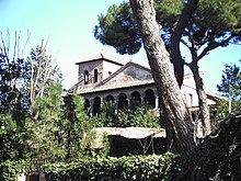
San Saba (Rione)
San Saba is the XXI. Rione (district) of Rome .
location
The Rione extends over the hill of the Little Aventine and the adjoining valley to the east in the southeast of the Roman old town ( Municipio I Centro Storico ). To the northwest to the Aventine , Viale Manlio Gelsomini and Viale Aventino form the border, to the northeast the Viale delle Terme di Caracalla and Via di Porta San Sebastiano , which form the first mile of the Via Appia . To the south, San Saba is bounded by the Aurelian Wall , which is particularly well preserved in this area. The center of the Rione is Piazza Gian Lorenzo Bernini , where a market takes place every morning.
history
On the Little Aventine, Remus is said to have asked the Auspicium , the bird flight oracle, about the founding of Rome. This is why the area was called Remuria in ancient times . In the densely populated area were the temples of Bona Dea and Silvanus Salutaris . In the 3rd century, the Caracalla Baths were built at the foot of the hill .
In the Middle Ages, the district was almost completely deserted and was dominated by vineyards. Only a few churches and monasteries, such as the monastery of San Saba , continued to exist. Only after Rome became the capital of the Kingdom of Italy in 1871 did the repopulation slowly begin.
In 1921 the district was separated from the Rione Ripa and named after the old church in the center. Today San Saba is a quiet, green but also expensive residential area in the Roman old town.
Attractions
The main attraction are the ruins of the Caracalla Baths. The Via Appia runs along them on its first section to Porta San Sebastiano . In addition to the eponymous church of San Saba, there are the churches of Santa Balbina , Santi Nereo e Achilleo and San Cesareo in the Rione , all of which go back to the early days of Christianity.
Web links
- Rione San Saba , Italian
- Rione San Saba on Google Maps


