
Sand on the Main
| coat of arms | Germany map | |
|---|---|---|

|
Coordinates: 49 ° 59 ' N , 10 ° 35' E |
|
| Basic data | ||
| State : | Bavaria | |
| Administrative region : | Lower Franconia | |
| County : | Hatred Mountains | |
| Height : | 228 m above sea level NHN | |
| Area : | 12.29 km 2 | |
| Residents: | 3142 (Dec. 31, 2019) | |
| Population density : | 256 inhabitants per km 2 | |
| Postal code : | 97522 | |
| Area code : | 09524 | |
| License plate : | HAS, EBN, GEO , HOH | |
| Community key : | 09 6 74 195 | |
| Community structure: | 1 district | |
| Address of the municipal administration: |
Kirchplatz 2 97522 Sand a.Main |
|
| Website : | ||
| Mayor : | Bernhard Russ ( SPD ) | |
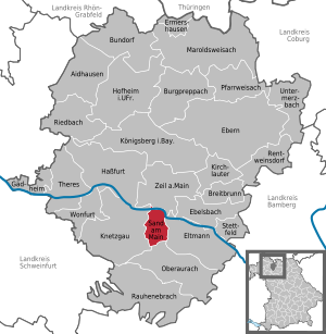
| Location of the municipality of Sand a.Main in the Haßberge district | ||
  |
||

Sand am Main (officially: Sand a.Main ) is a municipality in the Lower Franconian district of Haßberge . The place name most likely goes back to the location in the sandy main valley.
geography
Sand lies on the border of the Steigerwald Nature Park and the Main Valley . The community consists of two parts, which are separated by the Altmain . The districts of Wörth / Siedlung north of the Altmain are in the flood area .
Neighboring municipalities are (starting from the north clockwise): Zeil am Main , Eltmann , Oberaurach and Knetzgau .
The Franconian Marienweg leads through Sand am Main .
history
Prehistoric finds on the banks of the Main in sand date from the Paleolithic to the Celtic era. The first sanders were probably descendants of Germanic ancestors. The field name "Aschwinge" probably goes back to a pre-Christian cult site and is also the site of a medieval desert . The Franconians settled in the course of the Franconian conquest in the 6th – 8th centuries. Century in the Sander area. The division of the area around the Main into different regions goes back to them. Sand belonged to the Volkfeldgau , which lay between Volkach and Altenburg near Bamberg . With the Franks, Christianity spread in the area of the Main Valley. The place was first mentioned in a document when it was donated to the Michelsberg Monastery in Bamberg in 1139. Due to the location of the place on the Main, shipping and fishing played an important role here. As part of the Bamberg bishopric , which was part of the Franconian Empire from 1500 , sand fell to the Grand Duchy of Würzburg after secularization in 1803 in favor of Bavaria as part of border adjustments in 1810 . In 1814 it finally came to Bavaria .

Altmain Wine Festival 2003

Altmain Wine Festival 2011

Quarry pond near sand
View of the "Hohe Wann"

Fishing in sand

Marketplace

church Square

"Sander Raaser" on the church square

The church square to the Pfarrgasse

Altarm of the Main / Sandwörth

Flooding of Zeiler Strasse in 2013


politics

mayor
Bernhard Russ (SPD) has been mayor since July 1, 1993; he was last elected on April 9, 2017 for a further six years. Ruß is also a member of the Lower Franconian District Assembly .
Municipal council
| CSU | SPD | Free Sander Citizens | Young citizens | total | |
| 2002 | 6th | 4th | 4th | 2 | 16 seats |
| 2008 | 8th | 4th | 4th | - | 16 seats |
| 2014 | 8th | 4th | 4th | - | 16 seats |
coat of arms
The description of the coat of arms introduced in 1974 reads: “Diagonally left divided by red and gold; above a silver fish placed obliquely to the left, below a black basket with handles ”.
Monuments
Architectural monuments
Soil monuments
Economy and Infrastructure
Agriculture
A traditional branch of agriculture, viticulture , is still alive today in sand. The local vintners grow their wine on the mountain slopes around the village . The summer Altmain wine festival is the highlight of the event year. With around 50,000 visitors over four days, it is one of the most popular festivals in the area. In addition, around eight Sander winemakers are currently running their own hedge management .
Basket making
The basket-making flourished in the 18th century and developed in the next 200 years the most important sector of the community. Today, however, basket making only plays a subordinate role; basket trading is more pronounced, in which some companies have specialized and some are also internationally active.
traffic
- two kilometers to the A 70 motorway
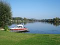
- Sand lies south of the navigable river Main .
- two kilometers to the B 26
- two kilometers to the Bamberg – Würzburg railway line ( Zeil station )
leisure

- Permanent campsite at Sander Baggersee
- Tennis courts
- Bowling lane in the sports center of the SKK Alle Neun Sand
- Motocross / Offroad racetrack and RC car racetrack of the MSC Sand 1951 e. V.
- Various possibilities for fishing on the Main, Altmain and the quarry ponds
- Numerous hiking opportunities in the nearby Haßberge and Steigerwald nature parks
Web links
- Official website of the municipality
- Entry on the coat of arms of Sand am Main in the database of the House of Bavarian History
Individual evidence
- ↑ "Data 2" sheet, Statistical Report A1200C 202041 Population of the municipalities, districts and administrative districts 1st quarter 2020 (population based on the 2011 census) ( help ).
- ↑ Sand am Main (district of Haßberge): Wasserwacht sets up a boat shuttle service ( page no longer available , search in web archives ) Info: The link was automatically marked as defective. Please check the link according to the instructions and then remove this notice. , Flood in Sand am Main, on January 11, 2011 on br-online.de, seen January 16, 2011

Aidhausen | Breitbrunn | Bundorf | Burgpreppach | Ebelsbach | Boars | Eltmann | Ermershausen | Gädheim | Hassfurt | Hofheim in Lower Franconia | Kirchlauter | Knetzgau | Königsberg in Bavaria | Maroldsweisach | Oberaurach | Pfarrweisach | Rauhenebrach | Rentweinsdorf | Riedbach | Sand am Main | Stettfeld | Theres | Untermerzbach | Wonfurt | Zeil am Main