Schwyz district
| Schwyz district | |
|---|---|
| Basic data | |
| Country: |
|
| Canton : |
|
| Main town : | Schwyz |
| FSO number : | 0506 |
| Area : | 494.32 km² |
| Height range : | 413–2800 m above sea level M. |
| Residents: | 55,382 (December 31, 2018) |
| Population density : | 112 inhabitants per km² |
| Website: | www.region-schwyz.ch |
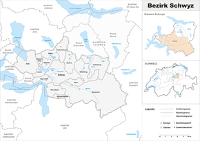
| map | |
The district of Schwyz (pronunciation [ ʃviːts ]) is a district of the canton of Schwyz in Switzerland .
With 494.32 km², the Schwyz district covers about half of the canton's area, but just under two fifths of the population. In terms of population and area, it is by far the largest of the six districts.
Geographical location
The Schwyz district comprises the area between Lake Zug and Lake Lucerne , the Muota valley and the Beaver valley towards Einsiedeln . It roughly corresponds to the old state of Schwyz, which had historical significance as a state of Schwyz for centuries .
15 political communities belong to the district . The area also includes parts north of the watershed on the Mythen , which is due to the expansion of the land in the Old Confederation.
Political communities
| coat of arms | Name of the parish | Population (December 31, 2018) |
Area in km² |
Inhabitants per km² |
|---|---|---|---|---|
|
|
Alpthal | 616 | 22.88 | 27 |
|
|
Arth | 11,985 | 42.04 | 285 |
|
|
Illgau | 802 | 10.95 | 73 |
|
|
Ingenbohl | 8913 | 13.40 | 665 |
|
|
Lauerz | 1100 | 9.19 | 120 |
|
|
Morschach | 1159 | 20.83 | 56 |
|
|
Muotathal | 3527 | 172.14 | 20th |
|
|
Oberiberg | 902 | 33.17 | 27 |
|
|
Riemenstalden | 90 | 11.20 | 8th |
|
|
Rothenthurm | 2411 | 22.75 | 106 |
|
|
saddle | 1938 | 17.39 | 111 |
|
|
Schwyz | 15,181 | 53.18 | 285 |
|
|
Stones | 3417 | 11.85 | 288 |
|
|
Steinerberg | 946 | 6.92 | 137 |
|
|
Unteriberg | 2395 | 46.43 | 52 |
| Total (15) | 55,382 | 494.32 | 112 | |
Changes in the community
- 1884: Division of Iberg → Oberiberg and Unteriberg
Localities
| Postcode | Name of the place | local community |
|---|---|---|
| 8849 | Brunni | Alpthal |
| 6410 | Goldau | Arth |
| 6414 | Oberarth | Arth |
| 6410 | Rigi Klösterli | Arth |
| 6410 | Rigi Kulm | Arth |
| 6410 | Rigi Scheidegg | Arth |
| 6410 | Rigi Staffel | Arth |
| 6440 | Fountain | Ingenbohl |
| 6440 | Unterschönenbuch | Ingenbohl |
| 6433 | Axenstein | Morschach |
| 6433 | Stoos SZ | Morschach |
| 6434 | Oberberg | Illgau |
| 6436 | Bisisthal | Muotathal |
| 6436 | Hinterthal | Muotathal |
| 6436 | Ried SZ | Muotathal |
| 6436 | Schachen | Muotathal |
| 6436 | Wil SZ | Muotathal |
| 8843 | Nut dishes | Oberiberg |
| 8843 | Chalun | Oberiberg |
| 6418 | Altmatt | Rothenthurm |
| 6417 | Ecce Homo SZ | saddle |
| 6438 | Ibach | Schwyz |
| 8843 | Ibergeregg | Schwyz |
| 6438 | Oberschönenbuch | Schwyz |
| 6432 | Rickenbach SZ | Schwyz |
| 6423 | Seewen SZ | Schwyz |
| 6422 | Adelboden near stones | Stones |
| 8842 | Hoch-Ybrig |
Unteriberg Oberiberg |
| 8842 | Sticks | Unteriberg |
| 8845 | Hours SZ | Unteriberg |
| 8842 | Waag SZ | Unteriberg |
history
Along with Uri and Unterwalden, Schwyz is one of the three old towns that founded the Old Confederation in 1291 . The dispute with the Einsiedeln monastery became important for the history of the valley . The abbey, founded in Strasbourg in 934, received large estates from the Swabian dukes and the Roman-German emperors. This also included the Sihl, Alp and Biber. In the 11th century , livestock farming spread. To do this, more pastureland and alpine pastures were needed. There were enough of these on the other side of the watershed ( Biberegg - Haggenegg - Holzegg - Ibergeregg ) and thus in the monastery area. Rural clearing and the kidnapping of the monks by the Schwyzer led to a campaign of revenge by the Habsburgs, who had been masters of the Waldstatt since 1283 . The victory in this military conflict ( Battle of Morgarten in 1315 ) finally secured the Schwyzers possession of considerable areas beyond the myths .
Individual evidence
- ↑ Permanent and non-permanent resident population by year, canton, district, municipality, population type and gender (permanent resident population). In: bfs. admin.ch . Federal Statistical Office (FSO), August 31, 2019, accessed on December 22, 2019 .
- ↑ Federal Statistical Office Generalized Limits 2020.
Web links
- Website of the district of Schwyz
- Erwin Horat: Schwyz (district). In: Historical Lexicon of Switzerland .


