
Tartegnin
| Tartegnin | |
|---|---|
 |
|
| State : |
|
| Canton : |
|
| District : | Nyon |
| BFS no. : | 5862 |
| Postal code : | 1180 |
| Coordinates : | 513 799 / 146737 |
| Height : | 492 m above sea level M. |
| Height range : | 427–814 m above sea level M. |
| Area : | 1.09 km² |
| Residents: | 248 (December 31, 2018) |
| Population density : | 228 inhabitants per km² |
| Website: | www.tartegnin.ch |
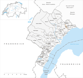
| Location of the municipality | |
  |
|
Tartegnin is a municipality in the Nyon district in the canton of Vaud in Switzerland .
geography
Tartegnin is 492 m above sea level. M. , 11 km northeast of the district capital Nyon (air line). The wine-growing village extends slightly higher on the lower southern slope of the Vaudois Côte in the middle of the vineyards on the Flon village stream , in a panoramic location around 120 m above lake level of Lake Geneva .
The area of the municipal area of just 1.1 km² covers a section in the central part of the Vaudois Côte. The communal soil extends in a narrow strip from the foot of the slope northwards over the vineyard slope and the subsequent forest-covered steep slope up to the height at La Gillière . Here with 810 m above sea level. M. reached the highest point of Tartegnin. The river Flon forms the eastern border . In 1997 7% of the municipal area was accounted for by settlements, 40% by forests and woodlands and 53% by agriculture.
Tartegnin has a number of wineries. The neighboring villages of Rolle in the West Gilly , the north and east Essertines-sur-Rolle , in the southeast of Mont-sur-Rolle and in the south part .
population
With 248 inhabitants (as of December 31, 2018), Tartegnin is one of the small communities in the canton of Vaud. 86.1% of the residents are French-speaking, 4.1% English-speaking and 3.6% Portuguese-speaking (as of 2000). The population of Tartegnin was 174 in 1900. After the population had decreased to 130 by 1980, a clearly increasing trend has been observed since then.
economy
Tartegnin was predominantly an agricultural village until the middle of the 20th century . Agriculture still plays an important role as a livelihood for the population. On the entire slope of the Côte below an altitude of 550 to 600 m above sea level. M. is operated viticulture . Further jobs are available in the service sector. In the last few decades the village has developed into a residential community thanks to its attractive location. Many employees work abroad and sometimes commute to the cities of Lausanne and Geneva .
traffic
The community has good transport connections. It lies a little above the main road that leads from Nyon along the slopes of the Côte to Aubonne . The Rolle motorway junction on the A1 (Geneva-Lausanne) opened in 1964 is around 2 km from the town. Tartegnin is connected to the public transport network via the Postbus course, which runs from Rolle to Gland .
history
The place was first mentioned in the 11th century under the name Tritiniaco . The names Tertygnens (1265) and Tertinnie appeared later . Tartegnin has belonged to the Mont-le-Vieux dominion since the Middle Ages . With the conquest of Vaud by Bern in 1536, the village came under the administration of the Bailiwick of Morges . After the collapse of the Ancien Régime , Tartegnin belonged to the canton of Léman from 1798 to 1803 during the Helvetic Republic, which then became part of the canton of Vaud when the mediation constitution came into force . In 1798 it was assigned to the Rolle district.
Attractions
Tartegnin has a compact town center with several typical wine-growing houses from the 17th to 19th centuries. The place does not have its own church, it belongs to the Gilly parish .
literature
- Paul Bissegger: Les monuments d'art e d'histoire du Canton de Vaud, Tome VII: Rolle et son district. Edited by the Society for Swiss Art History GSK. Bern 2012 (Art Monuments of Switzerland, Volume 120) ISBN 3-7643-1208-4 . Pp. 378-382.
Web links
- Official website of the municipality of Tartegnin (French)
- Germain Hausmann: Tartegnin. In: Historical Lexicon of Switzerland .
- Aerial photography
Individual evidence
- ↑ Permanent and non-permanent resident population by year, canton, district, municipality, population type and gender (permanent resident population). In: bfs. admin.ch . Federal Statistical Office (FSO), August 31, 2019, accessed on December 22, 2019 .
Arnex-sur-Nyon | Arzier-Le Muids | Basins | Begnins | Bogis-Bossey | Borex | Bursinel | Bursins | Burtigny | Chavannes-de-Bogis | Chavannes-des-Bois | Chéserex | Coinsins | Commugny | Coppet | Crans-près-Céligny | Crassier | Duillier | Dully | Essertines-sur-Rolle | Eysins | Founex | Genolier | Gilly | Gingins | Givrins | Gland | Grens | Longirod | Luins | Marchissy | Lousy | Mont-sur-Rolle | Nyon | Perroy | Prangins | La rib | Role | Saint-Cergue | Saint George | Signy-Avenex | Tannay | Tartegnin | Trélex | Le Vaud | Vich | Vinzel
Canton of Vaud | Districts of the canton of Vaud | Municipalities of the canton of Vaud