
Luins
| Luins | |
|---|---|
 |
|
| State : |
|
| Canton : |
|
| District : | Nyon |
| BFS no. : | 5858 |
| Postal code : | 1184 |
| Coordinates : | 510452 / 144161 |
| Height : | 460 m above sea level M. |
| Height range : | 395–726 m above sea level M. |
| Area : | 2.67 km² |
| Residents: | 611 (December 31, 2018) |
| Population density : | 229 inhabitants per km² |
| Website: | www.luins.ch |
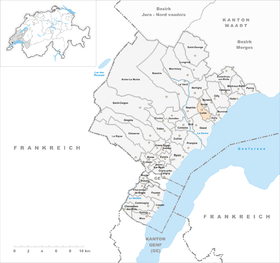
| Location of the municipality | |
  |
|
Luins is a municipality in the Nyon district in the canton of Vaud in Switzerland .
geography
Luins is at 460 m above sea level. M. , 7 km north-northeast of the district capital Nyon (air line). The wine-growing village extends slightly higher on the lower southern slope of the Vaudois Côte, in a panoramic position around 80 m above the lake level of Lake Geneva .
The area of the municipal area of 2.7 km² covers a section in the western part of the Vaudois Côte. The community soil extends from the plateau at the foot of the Côte between the streams of Lavasson in the west and Dullive in the east to the north up the vineyard slope of the Côte to the plateau near Burtigny. Here with 726 m above sea level. M. reached the highest point of Luins. In 1997, 11% of the municipal area was in settlements, 12% in forests and woodlands, 76% in agriculture and a little less than 1% was unproductive land.
The hamlets of Le Bagnu ( 445 m above sea level ) and Combes ( 475 m above sea level ) on the slope of the Côte west of the village, part of the houses of Le Vernay ( 417 m above sea level ) on the belong to Luins Plateau at the foot of the slope, as well as several wineries and individual farms. Neighboring municipalities to Luins are Gland , Begnins , Burtigny , Vinzel , Bursins and Dully .
population
With 611 inhabitants (as of December 31, 2018), Luins is one of the small communities in the canton of Vaud. 79.5% of the residents are French-speaking, 7.5% Portuguese-speaking and 6.5% English-speaking (as of 2000). The population of Luins was 266 in 1900. After the population had decreased to 226 by 1980, the number of inhabitants has since doubled, although a very restrictive spatial plan was put into effect in 1979.
economy
Up until the second half of the 20th century, Luins was a predominantly agricultural village. Agriculture still plays an important role as a livelihood for the population. On the entire slope of the Côte below an altitude of 550 to 600 m above sea level. M. is operated viticulture . On the plateau at the foot of the slope, agriculture and fruit growing predominate on the fertile soils , while dairy farming predominates on the plateau of Burtigny . Further jobs are available in the commercial and service sectors. In the last few decades the village has developed into a residential community thanks to its attractive location. Many employees work abroad and sometimes commute to the cities of Lausanne and Geneva .
traffic
The community has good transport connections. It is on the main road that leads from Nyon along the slopes of the Côte to Aubonne . The Gland motorway junction on the A1 (Geneva-Lausanne) opened in 1964 , which crosses the municipality, is around 3 km from the town. Luins is connected to the public transport network via the Postbus course, which runs from Gland to Rolle .
history
The first written mention of the place took place in 1115 under the current name; In 1335 the spelling Luyns appeared . Since the Middle Ages Luins belonged to the dominion of Cossonay ; in the 15th century the village was under the rule of Mont-le-Vieux. With the conquest of Vaud by Bern in 1536, Luins came under the administration of the Bailiwick of Morges . The Luins castle belonged from 1582 to 1809 the family von Wattenwyl . After the collapse of the Ancien Régime , the village belonged to the canton of Léman from 1798 to 1803 during the Helvetic Republic, which then became part of the canton of Vaud when the mediation constitution came into force . In 1798 it was assigned to the Rolle district.
Attractions
The parish church of Saint-Pierre stands on the slope above the village in the middle of the vines. In the Middle Ages it belonged to the Payerne Benedictine priory . The current building dates from 1674. On September 9, 1961, Liselotte Pulver and Helmut Schmid's wedding took place in the church . Luins Castle was built in the 18th century. Some characteristic wine-growing houses from the 17th to 19th centuries have been preserved in the town center.
literature
- Paul Bissegger: Les monuments d'art e d'histoire du Canton de Vaud, Tome VII: Rolle et son district. Edited by the Society for Swiss Art History GSK. Bern 2012 (Art Monuments of Switzerland, Volume 120) ISBN 3-7643-1208-4 . Pp. 176-188.
Web links
- Official website of the municipality of Luins (French)
- Germain Hausmann: Luins. In: Historical Lexicon of Switzerland .
- Aerial photography
Individual evidence
- ↑ Permanent and non-permanent resident population by year, canton, district, municipality, population type and gender (permanent resident population). In: bfs. admin.ch . Federal Statistical Office (FSO), August 31, 2019, accessed on December 22, 2019 .
- ↑ Liselotte Pulver: What passes is not lost. Hamburg 2019. pp. 98, 103.
Arnex-sur-Nyon | Arzier-Le Muids | Basins | Begnins | Bogis-Bossey | Borex | Bursinel | Bursins | Burtigny | Chavannes-de-Bogis | Chavannes-des-Bois | Chéserex | Coinsins | Commugny | Coppet | Crans-près-Céligny | Crassier | Duillier | Dully | Essertines-sur-Rolle | Eysins | Founex | Genolier | Gilly | Gingins | Givrins | Gland | Grens | Longirod | Luins | Marchissy | Lousy | Mont-sur-Rolle | Nyon | Perroy | Prangins | La rib | Role | Saint-Cergue | Saint George | Signy-Avenex | Tannay | Tartegnin | Trélex | Le Vaud | Vich | Vinzel
Canton of Vaud | Districts of the canton of Vaud | Municipalities of the canton of Vaud