
Begnins
| Begnins | |
|---|---|
 |
|
| State : |
|
| Canton : |
|
| District : | Nyon |
| BFS no. : | 5704 |
| Postal code : | 1268 |
| Coordinates : | 508 507 / 143 974 |
| Height : | 541 m above sea level M. |
| Height range : | 445–723 m above sea level M. |
| Area : | 4.79 km² |
| Residents: | 1952 (December 31, 2018) |
| Population density : | 408 inhabitants per km² |
| Website: | www.begnins.ch |
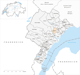
| Location of the municipality | |
  |
|
Begnins is a municipality in the Nyon district in the canton of Vaud in Switzerland .
geography
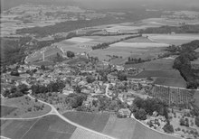
Begnins is 541 m above sea level. M. , 6 km north of the district capital Nyon (air line). The village extends on a terrace at the southern foot of the Jura , east of the Serine valley, in a panoramic position around 170 m above the lake level of Lake Geneva . The road over the Col du Marchairuz connects Begnins with Le Brassus in the Vallée de Joux .
The 4.8 km² municipal area covers a section of the Vaudois Côte. The communal soil extends from the foot of the Jura northward over the vineyards of the Côte and the terrace of Begnins to the height of the western Côte in front of the Jura, at 720 m above sea level. M. the highest point of the municipality is reached. The brook Nant flows east of the village center into the Lavasson and this flows in the south at Les Sâles over the municipality boundary of Gland. The western boundary of the municipality with the neighboring municipality of Vich is formed by the Serine , which has carved a deep valley into the heights at the foot of the Jura over the course of millions of years. In the east, the municipal boundary follows the Vorzairie stream . In 1997, 14% of the municipal area was accounted for by settlements, 18% for forests and woodlands and 68% for agriculture.
Begnins has a number of individual farms and wineries. Neighboring municipalities to Begnins are Vich , Gland , Luins , Burtigny , Le Vaud and Bassins .
population
With 1952 inhabitants (as of December 31, 2018) Begnins is one of the medium-sized municipalities in the canton of Vaud. 81.4% of the residents are French-speaking, 7.1% German-speaking and 4.6% English-speaking (as of 2000). The population of Begnins was 734 in 1850, and 782 in 1900. After 1960 (766 inhabitants) a rapid population increase began.
economy
Begnins was mainly an agricultural village until the middle of the 20th century . The slopes, which are optimally exposed to the south, are ideally suited for viticulture , which still plays a major role today as a branch of the population. There is also arable farming . Further jobs are available in local small businesses and in the service sector. In the 18th and 19th centuries, Begnins was an important trading center on the foot of the Jura with annual markets for agricultural products. Thanks to its attractive location, Begnins has developed into a residential community in recent decades. Many workers are commuters who work mainly in Nyon or Geneva .
traffic
The community has good transport connections. It is located on the main road from Gland to Saint-Cergue , the Gland motorway junction on the A1 is only around 2 km from the village. Begnins is connected to the public transport network by the post bus lines that run from Nyon to Gimel and from Gland to Burtigny. From 1906 to 1954 the Gland – Begnins (GB) overland tram operated.
history

The municipality of Begnins was settled early, as evidenced by the discovery of a burial ground (with rich additions) from the La Tène period and a Roman milestone from around 250 AD. The first written mention of the place took place in 1145 under the name Bingins . Other spellings appeared later: Binnins (1204) and Bîgnins (1226). The place name probably goes back to the Burgundian personal name Bino and means for the people of the Bino .
Since the first mention of the nobles of Begnins, the vassals of the lords of Prangins were attested . In 1293 Begnins came to the Counts of Savoy . With the conquest of Vaud by Bern in 1536, the village came under the administration of the Nyon bailiffs , and Begnin's rule was owned by members of the Stürler family in the 18th century . The former municipality of Serraux, which today only consists of a few houses, merged with Begnins in 1767. After the collapse of the Ancien Régime , the village belonged to the canton of Léman from 1798 to 1803 during the Helvetic Republic, which then became part of the canton of Vaud when the mediation constitution came into force .
Attractions
The parish church of Notre-Dame, founded in the 11th century, was later rebuilt several times. The single-nave building contains a choir with a ribbed vault and a tower, which was also used as a defense tower in earlier times. The three chapels on the south side of the nave date from the 14th and 15th centuries.
The Château du Martheray used to be the seat of the noble von Begnins family. The 16th century building was fundamentally changed in the 19th century, the hexagonal stair tower from 1671 has been preserved. The Château de Cottens on the eastern edge of the village is a medieval building that was redesigned in the 17th century. The Château de Menthon or de Rochefort is also a late medieval mansion, alterations were made in the 16th and 18th centuries. In the center there are numerous town houses and wine-growing houses from the 17th to 19th centuries.
Sons and daughters of the place
- Philippe-Sirice Bridel (1757–1845), author, local historian and clergyman
- Jean-Louis Bridel (1759–1821), Reformed clergyman, theologian and university professor and author
Web links
- Official website of the municipality of Begnins (French)
- Germain Hausmann: Begnins. In: Historical Lexicon of Switzerland .
- Germain Hausmann: Martheray. In: Historical Lexicon of Switzerland .
- Aerial photography
Individual evidence
- ↑ Permanent and non-permanent resident population by year, canton, district, municipality, population type and gender (permanent resident population). In: bfs. admin.ch . Federal Statistical Office (FSO), August 31, 2019, accessed on December 22, 2019 .
Arnex-sur-Nyon | Arzier-Le Muids | Basins | Begnins | Bogis-Bossey | Borex | Bursinel | Bursins | Burtigny | Chavannes-de-Bogis | Chavannes-des-Bois | Chéserex | Coinsins | Commugny | Coppet | Crans-près-Céligny | Crassier | Duillier | Dully | Essertines-sur-Rolle | Eysins | Founex | Genolier | Gilly | Gingins | Givrins | Gland | Grens | Longirod | Luins | Marchissy | Lousy | Mont-sur-Rolle | Nyon | Perroy | Prangins | La rib | Role | Saint-Cergue | Saint George | Signy-Avenex | Tannay | Tartegnin | Trélex | Le Vaud | Vich | Vinzel
Canton of Vaud | Districts of the canton of Vaud | Municipalities of the canton of Vaud