
Saint-Cergue
| Saint-Cergue | |
|---|---|
 |
|
| State : |
|
| Canton : |
|
| District : | Nyon |
| BFS no. : | 5727 |
| Postal code : | 1264 |
| Coordinates : | 501 600 / 144640 |
| Height : | 1041 m above sea level M. |
| Height range : | 598–1538 m above sea level M. |
| Area : | 24.28 km² |
| Residents: | 2575 (December 31, 2018) |
| Population density : | 106 inhabitants per km² |
| Website: | www.st-cergue.ch |
 Hotel Franco-Suisse at customs (CH / F), La Cure |
|
| Location of the municipality | |
  |
|
Saint-Cergue is a municipality in the Nyon district in the canton of Vaud in Switzerland .
geography
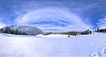
Saint-Cergue is 1041 m above sea level. M. , 9 km northwest of the district capital Nyon (air line). The village extends in a hollow above the Combe de Créva Tsevau, at the height of the foremost Jura range , at the Col de la Givrine pass , east of La Dôle .

The 24.3 km² municipal area covers a section of the Vaud Jura. Parts of the area belong to the protection zone of the Parc jurassien vaudois . The area extends on both sides of the Col de la Givrine valley cut in the Jura range between La Dôle in the south and Noirmont in the north. In the north, the municipality extends to the heights of Fruitières de Nyon ( 1330 m above sea level ) and Combe Grasse ( 1370 m above sea level ), in the south to the slopes of La Barillette and the Pointe de Fin Château (at 1530 m above sea level ) m above sea level, the highest point of Saint-Cergue). In the area of the Col de la Givrine there are the large forest areas Bois de la Pile and Bois de la Givrine . In the far west, on the border with France , Saint-Cergue extends into the uppermost catchment areas of the Bienne and Orbe . On the heights there are extensive Jura high pastures with the typical mighty spruce trees , which either stand individually or in groups. In a narrow corner, the area extends southeast down the densely wooded slope of the Côte de Nyon almost to the foot of the Jura. In 1997, 6% of the municipal area was in settlements, 65% in forests and woodlands, 28% in agriculture and a little less than 1% was unproductive land.
The settlement of La Cure ( 1155 m above sea level ), the border town west of the Col de la Givrine, numerous holiday home settlements and many individual farms, which are widely scattered on the Jura heights, belong to Saint-Cergue . The neighboring communities of Saint-Cergue are Gingins , Trélex , Givrins and Arzier-Le Muids in the canton of Vaud and Les Rousses and Prémanon in neighboring France .
population
With 2575 inhabitants (as of December 31, 2018), Saint-Cergue is one of the medium-sized municipalities in the canton of Vaud. 86.1% of the residents are French-speaking, 4.9% German-speaking and 4.2% English-speaking (as of 2000). The population of Saint-Cergue was 376 in 1900. After 1960 (460 inhabitants) a rapid increase in population began with a four-fold increase in the number of inhabitants within 40 years.
economy
Until the beginning of the 20th century, Saint-Cergue was mainly an agricultural village. Today agriculture with cattle breeding and dairy farming as well as forestry only play a marginal role as a branch of the village population. There are jobs in local trade and especially in the service sector (tourism). In the last few decades the village has also developed into a residential community. Many workers are commuters who work mainly in Nyon and Geneva .
tourism
Saint-Cergue developed into a mountain health resort after the middle of the 19th century, which experienced a further boom in 1916 with the opening of the narrow-gauge railway Nyon-Saint-Cergue-Morez (NStCM). Today Saint-Cergue is an important winter sports resort in the Upper Jura. However, the ski areas with numerous ski lifts on the north-western slope of La Dôle are located in the municipality of Gingins. The Jura heights are also suitable for cross-country skiing . Even in summer, Saint-Cergue is a popular destination for hikes and as a sports station. A swing golf course is operated on a private initiative and to promote the off-season .
traffic


The community has good transport connections. It is located on the main road from Nyon over the Col de la Givrine to Morez in France. The Nyon motorway junction on the A1 (Geneva – Lausanne) is around 12 km from the village. On July 12, 1916, the narrow-gauge railway from Nyon to Saint-Cergue was put into operation. Around a year later, on August 18, 1917, the sequel to La Cure was inaugurated. The railway line is operated by the Chemin de fer Nyon-Saint-Cergue-Morez (NStCM).
history
The first written mention of the place took place in 1110 under the name ecclesia Sancti Cyrici , in the 15th century the spelling Saint-Cergues appeared . Already at the beginning of the 12th century there was a church in Saint-Cergue, which was under the Abbey of Saint-Claude . The village had an important strategic importance on the Col de la Givrine, which was already popular with traders and merchants in the Middle Ages . Under the protection of the abbey, the Thoire-Villars family built a castle near Saint-Cergue in the 14th century and gave the village certain tax exemptions.
With the conquest of Vaud by Bern in 1536, Saint-Cergue came under the administration of the Nyon Bailiwick . After the collapse of the Ancien Régime , the village belonged to the canton of Léman from 1798 to 1803 during the Helvetic Republic, which then became part of the canton of Vaud when the mediation constitution came into force . In 1798 it was assigned to the Nyon district.
Attractions
Most of the current construction of the church of Saint-Cergue dates from the 19th century. Only small remains of the former castle ( Vieux Château ), which was destroyed by the Confederates during the Burgundian Wars, are left.
The Hotel Arbez Franco-Suisse in La Cure is considered to be the only hotel in the world that is in two countries: one part on Swiss and one on French territory.
Couvaloup

Local government
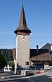
church
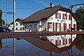
NStCM La Cure station


Personalities
- Yvan Leyvraz (1954–1986), Swiss aid worker and part of the international solidarity movement in Nicaragua , murdered in 1986 by Contras .
Web links
- Official website of the municipality of Saint-Cergue (French)
- Aerial photography
- Germain Hausmann: Saint-Cergue. In: Historical Lexicon of Switzerland .
Individual evidence
- ↑ Permanent and non-permanent resident population by year, canton, district, municipality, population type and gender (permanent resident population). In: bfs. admin.ch . Federal Statistical Office (FSO), August 31, 2019, accessed on December 22, 2019 .
Arnex-sur-Nyon | Arzier-Le Muids | Basins | Begnins | Bogis-Bossey | Borex | Bursinel | Bursins | Burtigny | Chavannes-de-Bogis | Chavannes-des-Bois | Chéserex | Coinsins | Commugny | Coppet | Crans-près-Céligny | Crassier | Duillier | Dully | Essertines-sur-Rolle | Eysins | Founex | Genolier | Gilly | Gingins | Givrins | Gland | Grens | Longirod | Luins | Marchissy | Lousy | Mont-sur-Rolle | Nyon | Perroy | Prangins | La rib | Role | Saint-Cergue | Saint George | Signy-Avenex | Tannay | Tartegnin | Trélex | Le Vaud | Vich | Vinzel
Canton of Vaud | Districts of the canton of Vaud | Municipalities of the canton of Vaud