
Longirod
| Longirod | |
|---|---|
 |
|
| State : |
|
| Canton : |
|
| District : | Nyon |
| BFS no. : | 5429 |
| Postal code : | 1261 |
| Coordinates : | 509 366 / 149 952 |
| Height : | 899 m above sea level M. |
| Height range : | 733–1494 m above sea level M. |
| Area : | 9.45 km² |
| Residents: | 478 (December 31, 2018) |
| Population density : | 51 inhabitants per km² |
| Website: | www.longirod.ch |
 Longirod, aerial view |
|
| Location of the municipality | |
  |
|
Longirod is a municipality in the Nyon district in the canton of Vaud in Switzerland .
geography
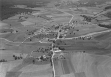
Longirod is 899 m above sea level. M. , 13 km north of the district capital Nyon (air line). The clustered village extends at a slightly southward slope on the southern slope of the Jura , in a panoramic position around 500 m above the lake level of Lake Geneva .
The 9.5 km² municipal area covers a section of the southern slopes of the Jura and the Vaud Jura. The communal soil extends in the southeast of the village over the Terrez hill ( 894 m above sea level ) into the lowlands of the Prévondavaux valley . This valley is a testimony to the last ice age , it was once a meltwater channel on the edge of the ice age Rhone glacier . To the northwest, the municipality extends to the anticline of the Mont-Tendre chain , which is densely forested in the Longirod area and has hardly any clearings. The highest point of the municipality is at 1495 m above sea level. M. the Crêt de la Neuve . The Gouffre de Longirod cave is located near the Pré de Rolle on the Jura ridge . The municipality lies on a watershed, the eastern part is drained via the Saubrette to the Aubonne , while the water from the western part leads to the Promenthouse via the Serine . In 1997, 3% of the municipal area was in settlements, 56% in forests and woodlands, 40% in agriculture and a little less than 1% was unproductive land.
Some individual farms belong to Longirod. Neighboring municipalities to Longirod are Saint-George , Gimel , Saint-Oyens , Burtigny , Marchissy and Le Chenit .
population
With 478 inhabitants (as of December 31, 2018) Longirod is one of the small communities in the canton of Vaud. 83.4% of the residents are French-speaking, 8.7% German-speaking and 4.7% English-speaking (as of 2000). Longirod's population was 309 in 1900. After the population had decreased to 200 by 1970, the population has increased significantly again since then.
economy
Longirod was predominantly an agricultural village until the second half of the 20th century . Agriculture still plays an important role as a livelihood for the population, with livestock and dairy farming dominating over arable farming . Further jobs are available in local small businesses and in the service sector. In the last few decades the village has developed into a residential community thanks to its attractive location. Many workers are therefore commuters who go to work in the larger towns along Lake Geneva.
traffic
The municipality is located on the cantonal road that leads from Gland via Saint-George over the Col du Marchairuz into the Vallée de Joux . Longirod is connected to the public transport network through the Postbus course, which runs from Nyon to Gimel .
history
A shell stone found in the forest of Outard east of Longirod testifies to the inspection and settlement of the municipality as early as the Neolithic . The first written mention of the place took place in 1267 under the name Longirot , later the spelling Longiro also appeared (for the first time in 1391). Longirod came as a fief to the lords of Aubonne in the 13th century.
Since the conquest of Vaud by Bern in 1536, Longirod shared the fortunes of Aubonne and in 1701 came to the Aubonne Bailiwick. In 1788 numerous houses fell victim to a conflagration. After the collapse of the Ancien Régime , the village belonged to the canton of Léman from 1798 to 1803 during the Helvetic Republic, which then became part of the canton of Vaud when the mediation constitution came into force . In 1798 it was assigned to the Aubonne district.
In 2010 the Long'I'Rock was held .
Attractions
The reformed parish church of Saint-Théodule dates from around 1440. In the town center, some farmhouses from the 18th and 19th centuries have been preserved.
Web links
- Official website of the municipality of Longirod (French)
- Germain Hausmann: Longirod. In: Historical Lexicon of Switzerland .
- Aerial photography
Individual evidence
- ↑ Permanent and non-permanent resident population by year, canton, district, municipality, population type and gender (permanent resident population). In: bfs. admin.ch . Federal Statistical Office (FSO), August 31, 2019, accessed on December 22, 2019 .
Arnex-sur-Nyon | Arzier-Le Muids | Basins | Begnins | Bogis-Bossey | Borex | Bursinel | Bursins | Burtigny | Chavannes-de-Bogis | Chavannes-des-Bois | Chéserex | Coinsins | Commugny | Coppet | Crans-près-Céligny | Crassier | Duillier | Dully | Essertines-sur-Rolle | Eysins | Founex | Genolier | Gilly | Gingins | Givrins | Gland | Grens | Longirod | Luins | Marchissy | Lousy | Mont-sur-Rolle | Nyon | Perroy | Prangins | La rib | Role | Saint-Cergue | Saint George | Signy-Avenex | Tannay | Tartegnin | Trélex | Le Vaud | Vich | Vinzel
Canton of Vaud | Districts of the canton of Vaud | Municipalities of the canton of Vaud