
Bursins
| Bursins | |
|---|---|
 |
|
| State : |
|
| Canton : |
|
| District : | Nyon |
| BFS no. : | 5853 |
| Postal code : | 1183 |
| Coordinates : | 511 707 / 145254 |
| Height : | 473 m above sea level M. |
| Height range : | 405–833 m above sea level M. |
| Area : | 3.37 km² |
| Residents: | 755 (December 31, 2018) |
| Population density : | 224 inhabitants per km² |
| Website: | www.bursins.ch |
_par_la_route_de_l%27Etraz.jpg) Bursins |
|
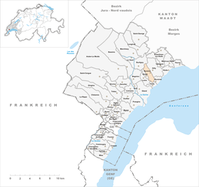
| Location of the municipality | |
  |
|
Bursins ( French [byʀsɛ̃] , Franco-Provencal [a brəˈsɛ̃] ) is a municipality in the Nyon district of the Swiss canton of Vaud .
geography
Bursins lies at 473 m above sea level. M. , 9 km north-northeast of the district capital Nyon (linear distance). The wine-growing village extends slightly higher on the lower southern slope of the Vaudois Côte , in a panoramic position around 100 m above lake level of Lake Geneva .
The area of the 3.4 km² municipal area covers a section of the Vaudois Côte. The municipality extends from the Fossy stream northwards over the plateau at the foot of the Côte to the Vaudois Côte ridge upstream of the Jura . The eastern border is formed by the Merdasson brook , which has carved a deep valley basin in this ridge through erosion over time, the Combe de Bursins, of which the western valley slope still belongs to Bursins. The highest elevation of Bursins is 830 m above sea level. M. at the height in the forest of the Grandes Tattes . In 1997, 10% of the municipal area was in settlements, 32% in forests and woodlands, 57% in agriculture and a little less than 1% was unproductive land.
Bursins includes the hamlet of Saint-Vincent ( 500 m above sea level ) on the slopes of the Vaudois Côte, the part of Le Vernay ( 415 m above sea level ) east of the Dullive brook and some farms. Neighboring communities to Bursins are Dully , Luins , Vinzel , Burtigny , Gilly and Bursinel .
population
With 755 inhabitants (as of December 31, 2018), Bursins is one of the smaller municipalities in the canton of Vaud. 83.7% of the residents are French-speaking, 5.9% German-speaking and 4.4% English-speaking (as of 2000). The population of Bursins was 340 inhabitants in 1850 and 424 in 1900. After the population had decreased to 264 inhabitants by 1970, a rapid population increase with a doubling of the population within 30 years began.
economy
Until the 20th century, Bursins was mainly an agricultural village. Even today, viticulture in the area of the village on the slope of La Côte and agriculture on the fertile soils of the plateau at the foot of the slope play an important role. Further jobs are available in local trade and especially in the service sector. The western part of the La Côte service area is located on the A1 motorway (Geneva - Lausanne) in the municipality . In the last few decades the village has developed into a residential community thanks to its attractive location. Many workers are commuters who work mainly in Nyon .
traffic
Although the community is located away from major thoroughfares, it is still well developed in terms of traffic. It is on the main road that leads from Nyon along the slopes of the Côte to Aubonne . The Postbus course, which runs from Gland to Rolle , connects Bursins to the public transport network.
history
The parish area was already settled in Roman times, which is evidenced by the remains of house foundations near the church. Some graves date from the Carolingian period. The first written mention of the place took place in 1011 under the name Bruzinges . The spellings Brucins (1031), Brucinis (1049) and Bruciniaco later appeared in the 11th century. The place name goes back to the Latin personal name Bruccius or Bruttius extended by the suffix -ānum and means "[property] of Bruccius / Bruttius".
The document from 1011 seals the donation of the village church to the Romainmôtier monastery by the Burgundian King Rudolf III. In the Middle Ages , Bursins was part of the Prangins rule . With the conquest of Vaud by Bern in 1536, Bursins came under the administration of the Bailiwick of Romainmôtier as an exclave .
After the collapse of the Ancien Régime , the village belonged to the canton of Léman from 1798 to 1803 during the Helvetic Republic, which then became part of the canton of Vaud when the mediation constitution came into force .
Attractions

- The Saint-Martin church, built in the 11th century, formed a small priory from 1238, which was under the Romainmôtier Abbey. The north apse is still preserved from the Romanesque building of the church. In the 14th and 16th centuries, several renovations took place, the choir is Gothic , while the tower is based on the Romanesque tradition. The Saint-Nicolas chapel is an important example of the flamboyant style. The rectory is now in the former priory building.
- The current construction of the Bursins Castle dates back to the 18th century; the castle has a late Gothic stair tower.
- Le Rosey Castle with its round towers dates from the late Middle Ages.
- In the old town center, some wine-growing and town houses from the 17th to 19th centuries have been preserved.
- Peter Ustinov has his final resting place in the Bursins cemetery .
Personalities
- Jean Louis Bonnet (1805-1892), Reformed clergyman
- Jean-Louis Ancrenaz (1814–1879), lawyer and politician
- Guy Parmelin (* 1959), winegrower, politician (SVP) and Federal Councilor
literature
- Laurent Auberson: Bursins. In: Historical Lexicon of Switzerland .
- Paul Bissegger: Les monuments d'art e d'histoire du Canton de Vaud. Volume VII: Rolle et son district. Edited by the Society for Swiss Art History GSK, Bern 2012 (Kunstdenkmäler der Schweiz Volume 120), ISBN 3-7643-1208-4 , pp. 66-104.
- A. Naef: Bursins. In: Revue historique vaudoise, Vol. 10 (1902), pp. 372–379. doi: 10.5169 / seals-11622
Web links
Individual evidence
- ↑ Permanent and non-permanent resident population by year, canton, district, municipality, population type and gender (permanent resident population). In: bfs. admin.ch . Federal Statistical Office (FSO), August 31, 2019, accessed on December 22, 2019 .
- ↑ a b Lexicon of Swiss municipality names . Edited by the Center de Dialectologie at the University of Neuchâtel under the direction of Andres Kristol. Frauenfeld / Lausanne 2005, p. 206.
Arnex-sur-Nyon | Arzier-Le Muids | Basins | Begnins | Bogis-Bossey | Borex | Bursinel | Bursins | Burtigny | Chavannes-de-Bogis | Chavannes-des-Bois | Chéserex | Coinsins | Commugny | Coppet | Crans-près-Céligny | Crassier | Duillier | Dully | Essertines-sur-Rolle | Eysins | Founex | Genolier | Gilly | Gingins | Givrins | Gland | Grens | Longirod | Luins | Marchissy | Lousy | Mont-sur-Rolle | Nyon | Perroy | Prangins | La rib | Role | Saint-Cergue | Saint George | Signy-Avenex | Tannay | Tartegnin | Trélex | Le Vaud | Vich | Vinzel
Canton of Vaud | Districts of the canton of Vaud | Municipalities of the canton of Vaud