
Coinsins
| Coinsins | |
|---|---|
 |
|
| State : |
|
| Canton : |
|
| District : | Nyon |
| BFS no. : | 5710 |
| Postal code : | 1267 |
| Coordinates : | 507 706 / 142 113 |
| Height : | 472 m above sea level M. |
| Height range : | 417-514 m above sea level M. |
| Area : | 2.91 km² |
| Residents: | 497 (December 31, 2018) |
| Population density : | 171 inhabitants per km² |
| Website: | www.coinsins.ch |
 Coinsins, painting by Barthélmy Menn |
|
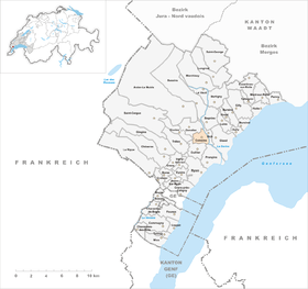
| Location of the municipality | |
  |
|
Coinsins [ kwɛ̃sɛ̃ ] is a municipality in the Nyon district in the canton of Vaud in Switzerland .
geography
Coinsins is located at 472 m above sea level. M. , 4.5 km north of the district capital Nyon (linear distance). The village extends on a terrace at the southern foot of the Jura , on the northern edge of the Promenthouse valley .
The area of the 2.9 km² municipal area includes a section at the southern foot of the Jura. The parish extends northwards over the Promenthouse river over the valley lowlands and the terrace of Coinsins to the edge of the Bois de Chênes . The Baigne aux Chevaux pond and the Grand Marais moorland are located in a wooded area . The western limit is the Ruisseau de Cordex , the eastern limit runs along the valley slope of the Sérine . The highest point of Coinsins is 510 m above sea level. M. on the southern edge of the Bois de Chênes. In 1997, 14% of the municipal area was in settlements, 16% in forests and woodlands, 69% in agriculture and a little less than 1% was unproductive land.
Some individual farms belong to coins. The neighboring communities of Coinsins are Duillier in the south, Prangins in the southeast , Vich in the east , Genolier in the north and Givrins in the west .
population
With 497 inhabitants (as of December 31, 2018), Coinsins is one of the small communities in the canton of Vaud. 78.3% of the residents are French-speaking, 7.3% English-speaking and 6.3% German-speaking (as of 2000). The population of Coinsins was 157 inhabitants in 1850, 188 inhabitants in 1900. After 1970 (169 inhabitants), the population began to grow rapidly, with the number of inhabitants doubling within 30 years.
economy
Coinsins was mainly an agricultural village until the second half of the 20th century . There is a large wine-growing area on the southern slope below and east of Coinsins . Thanks to the fertile soil, most of the remaining agricultural area is cultivated . In the new industrial zone, a company for pharmaceutical products, an electromechanical company and a paint shop were established. Over the past few decades, Coinsins has developed into a residential community. Many workers are commuters who work mainly in Nyon .
traffic
Although the community is located off the main thoroughfares, it is easily accessible from Gland . The Gland motorway junction on the A1 (Geneva-Lausanne) is only around 2 km from the village. Coinsins is connected to the public transport network via the Postbus course, which runs from Nyon to Gimel .
history
Finds of Bronze Age fireplaces, the remains of a Roman villa and early medieval graves point to a very early settlement of the municipality . The place was first mentioned in a document in 1212 under the name Quinsins . The spellings Quincins (1215), Quintins (1238), Cuynsins (1296), Cuinchins (1303), Cuinsins (1306) and Cuynsins (1332) appeared later .
A noble family lived in Coinsins from the beginning of the 13th century and acted as vassals of the Lords of Aubonne. The Oujon Monastery (near Arzier ) also owned the Mimorey farm near Coinsins. With the conquest of Vaud by Bern in 1536, the village came under the administration of the Nyon Bailiwick . After the collapse of the Ancien Régime , Coinsins belonged to the canton of Léman from 1798 to 1803 during the Helvetic period, which then went up with the enactment of the mediation constitution in the canton of Vaud. In 1798 it was assigned to the Nyon district.
Attractions
Coinsins Castle, built in 1725, is located at the eastern entrance to the village. It shows forms of the Empire style. In the town center, some wine-growing houses from the 17th to 19th centuries have been preserved. Coinsins does not have its own church; it has belonged to the parish of Vich since the Reformation .
Web links
- Official website of the municipality of Coinsins (French)
- Germain Hausmann: Coinsins. In: Historical Lexicon of Switzerland .
- Aerial photography
Individual evidence
- ↑ Permanent and non-permanent resident population by year, canton, district, municipality, population type and gender (permanent resident population). In: bfs. admin.ch . Federal Statistical Office (FSO), August 31, 2019, accessed on December 22, 2019 .
Arnex-sur-Nyon | Arzier-Le Muids | Basins | Begnins | Bogis-Bossey | Borex | Bursinel | Bursins | Burtigny | Chavannes-de-Bogis | Chavannes-des-Bois | Chéserex | Coinsins | Commugny | Coppet | Crans-près-Céligny | Crassier | Duillier | Dully | Essertines-sur-Rolle | Eysins | Founex | Genolier | Gilly | Gingins | Givrins | Gland | Grens | Longirod | Luins | Marchissy | Lousy | Mont-sur-Rolle | Nyon | Perroy | Prangins | La rib | Role | Saint-Cergue | Saint George | Signy-Avenex | Tannay | Tartegnin | Trélex | Le Vaud | Vich | Vinzel
Canton of Vaud | Districts of the canton of Vaud | Municipalities of the canton of Vaud