
Arzier-Le Muids
| Arzier-Le Muids | |
|---|---|
 |
|
| State : |
|
| Canton : |
|
| District : | Nyon |
| BFS no. : | 5702 |
| Postal code : | 1273 |
| Coordinates : | 505 445 / 146 153 |
| Height : | 870 m above sea level M. |
| Height range : | 561–1567 m above sea level M. |
| Area : | 51.90 km² |
| Residents: | 2698 (December 31, 2018) |
| Population density : | 52 inhabitants per km² |
| Website: | www.arzier.ch |
| Location of the municipality | |
  |
|
Arzier-Le Muids is a municipality in the Nyon district in the canton of Vaud in Switzerland . Until April 30, 2014, the municipality was officially called Arzier .
geography
Arzier is 870 m above sea level. M. , 9 km north of the district capital Nyon (linear distance). The village extends on the southern slopes of the Jura below the Molard, between the valleys of the Ruisseau d'Oujon in the west and the Ruisseau de la Combe in the east, in a panoramic position around 500 m above lake level of Lake Geneva .
The area of the municipal area of 51.9 km² covers a section of the Vaudois Jura. In the southeastern part of the Jura south slope of Arzier above the Bois de Chênes belong to the municipality, bounded in the east by the deeply cut valley of the Ruisseau de la Combe; west of the Ruisseau d'Oujon is the Côtes de Genolier forest slope . To the northwest, the area extends over the height of the Molard ( 1044 m above sea level ) and the Bois d'Oujon on the broad ridge of the foremost Jura chain. In the Arzier area, this is divided into several calcareous ribs that run from the southwest to the northeast according to the direction in which the Jura strikes, and intervening depressions that are partly boggy and have no drainage above ground, including the Marais Rouge and the Petite Enne . The greatest heights are in the western part of the ridge with the Noirmont ( 1567 m above sea level ; highest point of Arzier), Mont Pelé ( 1536 m above sea level ), Mont Sâla ( 1511 m above sea level ) and Vue de Genève ( 1492 m above sea level ). On the northern slope of the Noirmont lies the Creux du Croue , a characteristic evacuation cauldron that has been a nature reserve since 1987 . In the far north-west, the municipality extends to the right edge of the upper Orbe valley . Typical karst features such as sinkholes , cart fields and caves can be found on the Jura ridge . The little-used area, which lies in the protection zone of the Parc jurassien vaudois , consists of extensive forests, in between there are high Jura meadows with the typical mighty spruce trees , which either stand individually or in groups. In 1997, 3% of the municipal area was in settlements, 71% in forests and woodlands, 25% in agriculture and a little less than 1% was unproductive land.
Arzier-Le Muids includes the hamlet of Le Muids ( 696 m above sea level ) on a leveled area below the village and Montant ( 590 m above sea level ) on the foot of the Jura as well as numerous individual farms that are widely scattered on the heights of the Jura. The neighboring communities of Arzier are Saint-Cergue , Givrins , Genolier , Vich , Bassins and Le Chenit in the canton of Vaud, and Bois-d'Amont and Les Rousses in neighboring France .
population
With 2698 inhabitants (as of December 31, 2018), Arzier-Le Muids is one of the medium-sized municipalities in the canton of Vaud. 78.5% of the residents are French-speaking, 8.0% German-speaking and 6.9% English-speaking (as of 2000). The population of Arzier-Le Muids was 443 in 1850 and 342 in 1960. Only after 1970 (459 inhabitants) did a massive increase in population set in: Arzier-Le Muids had 857 inhabitants in 1980 and 1446 inhabitants in 1990.
economy
Arzier-Le Muids was mainly an agricultural village until the middle of the 20th century . In the lower parts of the community arable farming is practiced , while cattle breeding and dairy farming predominate on the Jura heights . The forestry thanks to the forest wealth is of great importance and was responsible for the relative prosperity of the community in the earlier years. There are other jobs in trade and the service sector. Arzier-Le Muids is the location of a research center for cardiovascular diseases. The large community and school center built under Vincent Mangeat was opened in 1988. Since around 1970, thanks to the beautiful location and still good transport connections, a rapid development towards the residential community began. The entire slope around the former village center was built over. The population has more than quadrupled since then. The vast majority of those in employment (more than 75%) work away from home, especially in Nyon and Geneva .
traffic

The community has good transport connections. It is on the main road from Gland to Saint-Cergue , the Gland motorway junction on the A1 is around 10 km from the village. On July 12, 1916, the Nyon - Saint-Cergue railway line began operating with stations in Arzier and Le Muids.
history

The place was first mentioned in a document in 1306 under the name Argie . Also in the 14th century the spellings Argier , Arsie and Arsier appeared . The place name probably goes back to the personal name Aredius or Aregius , which was common in the Merovingian period .
The village owes its development to the Carthusian monastery Oujon, founded in 1146 on the Jura ridge above Arzier. In order to reclaim the wilderness, the monks granted the settlers extensive tax exemption from 1304. The hamlet of Le Muids is also mentioned in 1250 as Au Muis owned by the monastery. With the conquest of Vaud by Bern in 1536, Arzier came under the administration of the Nyon bailiff . The monastery properties were confiscated and the buildings fell into disrepair over time. Since the community became increasingly impoverished and was no longer able to pay the taxes to Bern, Bern transferred the rule to the village in 1664 and waived further income. Arzier only had to pay taxes to the Nyon Bailiwick, which laid the foundation for the relative prosperity from the 18th century thanks to forest management. After the collapse of the Ancien Régime , the village belonged to the canton of Léman from 1798 to 1803 during the Helvetic Republic, which then became part of the canton of Vaud when the mediation constitution came into force .
Attractions
- The Saint-Antoine church was built in 1306. After the Reformation it was also the parish church for Bassins until 1687 and for Saint-Cergue until 1713.
- In a clearing in the Bois d'Oujon, the foundations of the former Carthusian monastery of Oujon are still visible.
photos
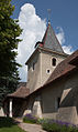
Saint Antoine (1306)

Parish hall
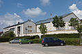
Pré Morlot school complex
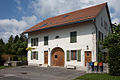
Typical farmhouse
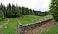
Ruins of the Carthusian monastery of Oujon, view from the east

Ruins of the Carthusian monastery in Oujon, view from the northwest


Web links
- Official website of the municipality of Arzier (French)
- Sabine Carruzzo-Frey: Arzier. In: Historical Lexicon of Switzerland .
- Aerial photography
Individual evidence
- ↑ Permanent and non-permanent resident population by year, canton, district, municipality, population type and gender (permanent resident population). In: bfs. admin.ch . Federal Statistical Office (FSO), August 31, 2019, accessed on December 22, 2019 .
- ^ Laurent Auberson: L'ancienne chartreuse Notre-Dame d'Oujon, Arzier (VD). . (Swiss Art Guide, No. 600). Ed. Society for Swiss Art History GSK. Bern 1996, ISBN 3-85782-600-2 .
Arnex-sur-Nyon | Arzier-Le Muids | Basins | Begnins | Bogis-Bossey | Borex | Bursinel | Bursins | Burtigny | Chavannes-de-Bogis | Chavannes-des-Bois | Chéserex | Coinsins | Commugny | Coppet | Crans-près-Céligny | Crassier | Duillier | Dully | Essertines-sur-Rolle | Eysins | Founex | Genolier | Gilly | Gingins | Givrins | Gland | Grens | Longirod | Luins | Marchissy | Lousy | Mont-sur-Rolle | Nyon | Perroy | Prangins | La rib | Role | Saint-Cergue | Saint George | Signy-Avenex | Tannay | Tartegnin | Trélex | Le Vaud | Vich | Vinzel
Canton of Vaud | Districts of the canton of Vaud | Municipalities of the canton of Vaud