
Vashon icing
| Vashon icing | ||
| 19,000 ... 16,000 BP | ||
| Vashon icing occurred in ... | ||
| Continent: | North America | |
| Current state: | United States | |
| Today's state: | Washington | |
| Region: | West Washington | |
| The Vashon icing occurred within the ... | ||
| Phanerozoic | 541,000,000 BP ... today | |
| Cenozoic | 66,000,000 BP ... today | |
| Quaternary | 2,588,000 BP ... today | |
| Pleistocene | 2,588,000 ... 11,700 BP | |
| Young Pleistocene | 126,000 ... 11,700 BP | |
| The Vashon glaciation was part of the ... | ||
| Cenozoic Ice Age | 2,588,000 BP ... today | |
| Last glacial period | 110,000 ... 12,000 BP | |
| Wisconsin icing | 85,000 ... 11,000 BP | |
| Fraser icing | 20,000 ... 10,000 BP | |
| Vashon icing | 19,000 ... 16,000 BP | |

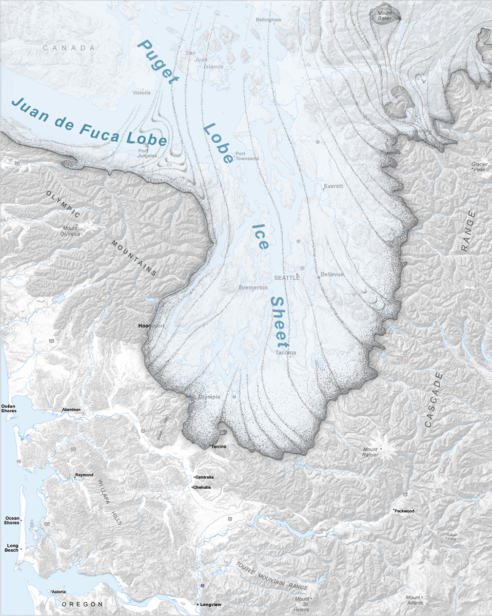
The Vashon glaciation or the Vashon Stadium (also Vashon Glacier ) is a local expression for the most recent period of very cold climates, during the climax of which the entire region on the Puget Sound and the Juan de Fuca Strait , i.e. the current ones Cities of Seattle , Tacoma and Olympia, as well as the areas surrounding them in the west of today's US state Washington , were covered by glaciers . This happened during what has become known as the last worldwide cold period . It is the most recent glacial period of the Quaternary glaciation . It is one of the climatic periods that have lasted for 2.58 million years.
The Vashon icing lasted from about 19,000 ... 16,000 BP ( Before Present - literally "before today", is usually meant - as in this article - before 1950). The Cordilleras Ice Sheet was an inland ice body that covered what is now southern Alaska and parts of what is now western Canada . During the Vashon glaciation, the Cordilleras Ice Sheet advanced into the Puget Sound region beyond what is now British Columbia .
The Cordilleras, Laurentides , Innuit Ice Sheets and the Greenland Ice Sheet , which still exists today , together formed the North American Ice Sheet Complex, which covered what is now Canada and most of what is now the United States. This glacial ice age is called the Wisconsin glaciation. The Fraser glaciation began when the Cordilleras Ice Sheet advanced from the mountains of British Columbia.
Climate (20,000 ... 16,000 BP)
During the Vashon glaciation, the climate in West Washington - as in most places - was colder than it is today. It was also much drier than it is now, which was characteristic of some places as opposed to others.
Pollen analysis data from Battle Ground Lake in the south of the Puget Sound region shows that annual mean temperatures in the area of 20,000 ... 16,000 BP are about 6 ± 1 ° C (10.8 ± 1.8 ° F) below today's ( 1990) and that annual precipitation was about one meter (39.4 inches) less. The area of today's Battle Ground Lake had an average annual precipitation of 1,324.4 millimeters (52.14 inches) between 1961 and 1990. One meter of precipitation less means that the mean precipitation of 20,000 ... 16,000 BP was only around 24.5% of the reference period from 1961 to 1990.
The Laurentide Ice Sheet had a major impact on the climate. This inland ice sheet covered much of what is now Canada and parts of what is now the United States in the Midwest and East. The Rocky Mountains separated the Laurentide from the Cordilleras Ice Sheet. The jet stream over North America was split in two by the cooling effect of the Laurentid Ice Sheet on the central areas of the continent . The southern branch was pushed further south than it is now, so storm lows spared most of the time over the Pacific Northwest . As a result, it was wetter in southern and central California than it is today.
| Average annual temperature and precipitation of 20,000 ... 16,000 BP | ||||
| City / place | Average annual temperature | Average annual precipitation | ||
|---|---|---|---|---|
| Aberdeen | 39.7 ° F (4.3 ° C) | 20.26 inches (514.6 mm) | ||
| Battle Ground | 40.2 ° F (4.6 ° C) | 12.77 inches (324.4 mm) | ||
| Centralia | 40.8 ° F (4.9 ° C) | 11.52 inches (292.6 mm) | ||
| Vancouver | 40.4 ° F (4.7 ° C) | 10.12 inches (256.9 mm) | ||
| The table is based on temperatures 6 ° C lower and precipitation decreased to 24.5% for the period from 1961 to 1990. Source for the mean values 1961–1990: Western Regional Climate Data Center The locations listed were not covered by the ice sheet. The calculation of climatic values over glaciers is much more complicated because of the height difference and the effect of the ice on the temperature. |
||||
The mean annual temperatures in the lowlands of what is now West Washington were above 0 ° C (32 ° F). This means that more ice thawed in summer than water froze in winter. This in turn meant that the climate was too warm for the maintenance of the glaciers, but the ice supply from the north was greater than the melt in the south.
The advance (19,000 ... 16,950 BP)
The following advance of the Cordillera Ice Sheet began more than 19,000 years ago. This point in time marks the presumed crossing of the border between Canada and the United States (49 ° north latitude) through the glaciers into what is now West Washington, which is generally regarded as the beginning of the Vashon glaciation. This southern part of the Cordillera Ice Sheet is called Puget Lobe (German for "Puget tongue"). During the Vashon glaciation, the Cordilleras Ice Sheet grew and advanced south at a rate of more than 135 meters per year. The Vashon glaciation actually started after the maximum of the last global glaciation, when glaciers retreated in most parts of the world; in West Washington they grew. About 18,350 BP, the Puget Lobe cut Puget Sound off the Juan de Fuca Strait, turning it into Ice Age Lake Russell . The glaciers reached today's Seattle up to around 17,950 BP, today's Tacoma up to around 17,650 BP, and today's Olympia up to around 17,350 BP. The Puget Lobe reached its maximum extent in the area of today's Tenino about 16,950 BP.
Maximum expansion (16,950 ... 16,850 BP)

The Puget Lobe remained at its maximum extent in the area around today's Tenino of around 16,950 BP ... around 16,850 BP, for a total of around 100 years. The thickness of the ice was about 1.6 km at what is now the Canadian-US border, about 1,000 m in Seattle and about 200 m at the edge of the glacier near Tenino.
Withdrawal (16,850 ... 16,000 BP)
At 16,850 BP, the Puget Lobe began to retreat northward at the rate of about 340 meters per year. Up to about 16,650 BP, this withdrawal only happened until about today's Olympics. The Puget Lobe began to share Lake Russell. Tacoma was reached by 16,450 BP, and Seattle was around 16,150 BP. By about 16,000 BP, the Puget Lobe withdrew to such an extent that Lake Russell and the Juan de Fuca Strait were reunited, making Lake Russell the marine waters of Puget Sound again.
Formation of kettle basins and lakes
In the mainland areas, the Puget Lobe left behind huge isolated ice blocks on its retreat, which broke off the glacier. The melting glacier created sediment-bearing streams and rivers whose debris buried the feet of the ice blocks. When these ice blocks melted, they left depressions in the bottom that filled with the meltwater and formed dead ponds.
Lake Carbon - Catastrophic floods in the Ice Age
Ice Age Lake Carbon was a lake created by the Puget Lobe that dammed the Carbon River. At around 16,850 BP, when the glacier began its retreat, the ice dam that formed the lake broke, causing massive flooding. The floods covered the northern and central parts of what is now Thurston County , part of Pierce County, and small parts of Lewis and Grays Harbor Counties .
Animals and plants during the Vashon glaciation
| domain | rich | Tribe / department | class | order | family | Genus & Art | Common name | Place & period | Current status |
|---|---|---|---|---|---|---|---|---|---|
| Eukaryota | Animals | Chordata | Mammalia | Artiodactyla | Bovidae | Bison | bison | Genus no longer exists in West Washington | |
| Eukaryota | Animals | Chordata | Mammalia | Artiodactyla | Bovidae | Ovibos moschatus | Musk ox | Art no longer exists in West Washington | |
| Eukaryota | Animals | Chordata | Mammalia | Carnivora | Canidae | Canis lupus | wolf | Species no longer exists in Western Washington due to hunting in the 2nd half of the 19th century until the 1930s. | |
| Eukaryota | Animals | Chordata | Mammalia | Carnivora | Felidae | Homotherium serum | Saber-toothed cat | Genus and species extinct worldwide | |
| Eukaryota | Animals | Chordata | Mammalia | Carnivora | Felidae | Panthera leo atrox | American lion | Subspecies extinct worldwide | |
| Eukaryota | Animals | Chordata | Mammalia | Carnivora | Felidae | Smilodon fatalis | Saber-toothed cat | Genus and species extinct worldwide | |
| Eukaryota | Animals | Chordata | Mammalia | Carnivora | Ursidae | Arctodus simus | Short-faced bear | Genus and species extinct worldwide | |
| Eukaryota | Animals | Chordata | Mammalia | Proboscidea | Elephantidae | Mammuthus columbi | Prairie mammoth | Genus and species extinct worldwide | |
| Eukaryota | Animals | Chordata | Mammalia | Proboscidea | Mammutidae | Mammoth americanum | American mastodon | Genus and species extinct worldwide | |
| Eukaryota | Animals | Chordata | Mammalia | Pilosa | Megalonychidae | Megalonyx jeffersonii | Jefferson ground sloth | Genus and species extinct worldwide | |
| Eukaryota | Animals | Chordata | Mammalia | Rodentia | Geomyidae | Thomomys mazama melanops | Mazama pocket rat | Species still exist in this area but are not common. | |
| Eukaryota | plants | Trachaeophyta | Coniferopsida | Pinales | Pinaceae | Abies lasiocarpa | Rock Mountain Fir | Puget Sound region, 21,000 ... 17,000 BP | The species is no longer considered a native plant in the Puget Sound region. |
| Eukaryota | plants | Trachaeophyta | Coniferopsida | Pinales | Pinaceae | Picea | Spruce | Olympic Peninsula - lowlands on the west side, 20,000… 16,000 BP | The genus is still a native plant in the area. |
| Eukaryota | plants | Trachaeophyta | Coniferopsida | Pinales | Pinaceae | Picea engelmannii | Engelmann spruce | Puget Sound region, 21,000 ... 17,000 BP | The species is no longer considered a native plant in the Puget Sound region. |
| Eukaryota | plants | Trachaeophyta | Coniferopsida | Pinales | Pinaceae | Pinus | jaw | Olympic Peninsula - lowlands on the west side, 20,000… 16,000 BP | The genus is still a native plant in the area. |
| Eukaryota | plants | Trachaeophyta | Coniferopsida | Pinales | Pinaceae | Pinus contorta | Coastal pine | Puget Sound region, 21,000 ... 17,000 BP | The species is still a native plant in the area. |
| Eukaryota | plants | Trachaeophyta | Coniferopsida | Pinales | Pinaceae | Tsuga heterophylla | Western hemlock | Olympic Peninsula - lowlands on the west side, 20,000… 16,000 BP | The species is still a native plant in the area. |
| Eukaryota | plants | Trachaeophyta | Coniferopsida | Pinales | Pinaceae | Tsuga mertensiana | Mountain hemlock | Olympic Peninsula - lowlands on the west side, 20,000… 16,000 BP | The species is still a native plant in the area. |
| Eukaryota | plants | Trachaeophyta | Coniferopsida | Pinales | Taxaceae | Taxus brevifolia | Pacific yew | Puget Sound region, 21,000 ... 17,000 BP | |
| Eukaryota | plants | N / A | N / A | Asterales | Asteraceae | Artemisia | sage | Puget Sound region, 21,000 ... 17,000 BP; Olympic Peninsula - west side near the alpine glaciers, 20,000… 16,000 BP | The genus is no longer a native plant in West Washington. |
| Eukaryota | plants | N / A | N / A | Fagales | Betulaceae | Alnus | Alders | Olympic Peninsula - lowlands on the west side, 20,000… 16,000 BP | The genus is still a native plant in the area. |
| Eukaryota | plants | N / A | N / A | Poales | Cyperaceae | Sedges | Puget Sound region, 21,000 ... 17,000 BP | The family is still a native plant in the area. | |
| Eukaryota | plants | N / A | N / A | Poales | Poaceae | Sweet grasses | Puget Sound region, 21,000 ... 17,000 BP; Olympic Peninsula - west side near the alpine glaciers, 20,000… 16,000 BP | The family is still found in the area as a native and non-native plant. |
After the Vashon period (16,000 BP ... present)
Pollen analysis data collected from Battleground Lake shows that temperatures between 16,000 and 15,000 BP were about 4 ± 2 ° C lower than today (1990). The amount of precipitation was roughly the same as today.
From around 14,000… 12,000 BP, coastal pines ( Pinus contorta ) increasingly migrated into the region, but the area remained largely open. The first human emergence in West Washington is currently dated to around 13,800 BP. A place where mastodons were hunted in this era was excavated in Sequim in 1977 .
From 12,000 BP… 10,000 BP further tree species settled in the area; a closed forest was created. The vegetation was similar to today's, with red alder ( Alnus rubra ), sitka spruce ( Picea sitchensis ), coastal pine ( Pinus contorta ), Douglas fir ( Pseudotsuga ) and western hemlock ( Tsuga heterophylla ).
The year 11,700 BP is generally considered to be the end of the Pleistocene and the beginning of the Holocene .
Between 9,500 and 4,500 BP during the period declared as the optimum climate of the Holocene ( Atlantic ), the temperatures in the area were about 2 ± 1 ° C (3.6 ± 1.8 ° F) above today's and the precipitation by 45 ± 5% below the current one. Between 9,500 and 5,000 BP there were alders ( Alnus ), Douglas firs ( Pseudotsuga ), eagle fans ( Pteridium ) and large stocks of Chrysolepis (English chinkapin) and oaks ( Quercus ).
Chronological sequence of the lakes
| Time (years BP) | event |
|---|---|
| 18,800 | The weight of the ice begins to depress the earth's crust. The trough and basin of Puget Sound were previously formed. |
| 18,300 | The Cordilleras Ice Sheet has filled in the Strait of Georgia and penetrates south into the Juan de Fuca Strait , where it flows into the ocean. The glacier front is north of the junction of Hood Canal and Admiralty Inlet and fills the Whidbey Basin. The sanders fill the entrance to Hood Canal, Admiralty Inlet and Possession Sound in an area from north of Everett to the south end of Whidbey Island . The ice is advancing south at a rate of 450 ft (137 m) per year. |
| Three freshwater lakes have filled the basin. Almost the entire length of the Hood Canal is open water. The largest body of water fills the East Passage, the Dalco Passage (Tacoma), with a river-like basin along the west coast of Vashon Island. A separate lake flows from Case Inlet and Nisqually Reach west of Tacoma through bottlenecks into the river, which flows north through the Colvos Passage. | |
| 18,100 | The ice sheet continues its southward expansion. It separates the Hood Canal from the other basins in Puget Sound. The ice front is exactly north of present-day Seattle and the sander covers all of Elliott Bay , from north of West Point to Blake Island in the south. |
| Three previously created freshwater lakes persist and grow weakly as the ice front advances south. | |
| 17,800 | The ice sheet has formed a uniformly arched front that extends from the mouth of the Dosewallips River southeast over the Kitsap Peninsula, through what is now Bremerton and the southern tip of Vashon Island to the Green River Valley in what is now Kent . Sander fill the middle sections of the Hood Canal, the Clifton Channel and 5… 8 km far reaching the Carr Inlet, the Colvos Channel, the Quartermaster Harbor and the east passage of the Puget Sound as well as a similar plain in the valley of the Green River from Kent to Auburn . |
| A single freshwater lake stretches across the glacier front and covers the lower Hood Canal as well as the flatter hills north of the Black Hills north of Olympia . A smaller body of water has filled the valleys of the Puyallup and White River . | |
| 17,500 | The glacier front extends to the northern border of today's Olympia. The entire basin of Puget Sound is filled with ice. A small arched sander covers 3… 5 km from the heights south of the Hood Canal south and east to the eastern cliffs at the mouth of the Nisqually River . A narrow body of water lies south of this plain and covers the area of today's Olympia. |
| 16,900 | The ice front reaches its southernmost point; it runs along the east side of the Olympic Mountains , south to the plains north of the Black Hills, bypasses their north side, extends in the south to the Black River Valley up to its confluence with the Chehalis River . The front stops on the flanks of Mount Rainier, turns north and unites with numerous small glaciers in the valleys on the eastern flank of the Cascade Range . The thickness of the ice sheet over Seattle is 3,000 ft (914 m) and lowers the surface of the earth in what is now Pioneer Square by up to 275 ft (84 m). |
| 16,600 | After 16,900 BP, the ice begins its retreat. By 16,600 BP it has returned to the north of today's Olympia, where it was 1,000 years earlier. |
| 16,500 | The ice continues its retreat. It is still south of present-day Tacoma and has created significant bodies of water. Lake Skokomish arises in the southern loop of the Hood Canal and in the lower reaches of the Skokomish River ; there is also the young Lake Russell or an older version of Lake Nisqually . |
| 16,400 | On the further retreat to the north, the ice front reaches the Kitsap Peninsula in an arc to the northwest from the south side of today's Tacoma, releases the southern hook of the Hood Canal and reaches the Olympic Mountains near Quilcene Bay . |
| A large body of water is created. | |
| 16,300 | The ice front is anchored on the western slope of the Olympic Mountains near Quilecene Bay. Lake Russell spreads across the southern basins of Puget Sound. Lake Hood drains into Lake Russell along its south side. From present-day Tacoma, the ice front extends about 10… 15 km to the north and lies across the Green River near present-day Kent. Within a very short period (a few decades) the glacier recedes by up to 24 kilometers. The area around what is now Bremerton and Renton is now ice-free. |
| 16,200 | The retreat continues at the increased speed, the area around what is now Seattle becomes the southern boundary of the ice sheet. The Hood Canal is completely absorbed into Lake Russell, only the highest points of the Kitsap Peninsula protrude from the water. |
| 16,100 | The withdrawal appears to have slowed or stalled; apparently the ice has thinned instead of receding. The water level of Lake Russell has fallen accordingly. |
| The upper reaches of the Stillaguamish River has formed a freshwater lake. The Lake Washington and Lake Sammamish emerge on the southern border of the lake formed as a separate body of water. | |
| 16,000 | The ice front has receded further north and opened the mouth of the Hood Canal ; it is just south of the south end of Whidbey Island . |
| The Stillaguamish River forms a freshwater lake along its entire length. Lake Sammamish is connected to Lake Washington along its current course; Lake Washington drains over Lake Union and later only over the Duwamish River at its southern end. | |
| 15,900 | The ice front has retreated north to the Juan de Fuca Strait, which connects Puget Sound to the ocean. The Duwamish-Green River Valley becomes rich in salt water through the sound. The Stillaguamish River is also a saltwater bay of the sound. |
| 7,500 | With the exception of the saltwater bay Duwamish-Green River, today's waterways are shaped. The Whidbey Basin has assumed a rudimentary shape, the Stillaguamish River flows into the Port-Susan Passage, and Skagit Bay has appeared. |
| 5,500 | The northern summit of Mt. Rainier collapses, sending a lahar to the White River . This creates the Auburn Delta in Duwamish Bay and separates the valleys of the Puyallup River and Green River. |
| 2,100 | An eruption of Mt. Rainier sends sand lahars into the White River Valley up to its confluence with the Duwamish River near today's Tukwila . |
| 1,100 | An earthquake in the Duwamish Valley lifts the valley 20 ft (6 m) and drains the left side of the saltwater indentation. This is how the Duwamish Delta is created, as is the area of today's port of Seattle. |
Web links
Individual evidence
- ↑ Jennifer Ott: Retreating glaciers create Puget Sound and Grand Coulee as the Ice Age ends about 15,000 years ago. In: HistoryLink . September 24, 2012, accessed November 18, 2016 .
- ^ The cordilleran ice sheet. (PDF) Retrieved August 18, 2018 .
- ↑ a b c d e f g h i j k l m n o p q r s t u v w Cathy Whitlock: Vegetational and Climatic History of the Pacific Northwest during the Last 20,000 Years: Implications for Understanding Present-day Biodiversity . In: The Northwest Environmental Journal . tape 8 , no. 5 . University of Washington , 1992 ( fed.us [PDF; accessed November 18, 2016]).
- ^ Period of Record Monthly Climate Summary: Battle Ground, Washington (450482). Western Regional Climate Data Center, accessed November 18, 2016 .
- ^ Robert S. Thompson, Katherine H. Anderson: Past Climate and Vegetation Changes in the Southwestern United States. United States Geological Survey , accessed November 18, 2016 .
- ↑ a b c d e f g Vashon Glaciation Animation. Earth and Space Sciences at the University of Washington, April 16, 2012, accessed November 18, 2016 .
- ↑ a b c d e Stephen C. Porter, Terry W. Swanson: Radiocarbon Age Constraints on Rates of Advance and Retreat of the Puget Lobe of the Cordilleran Ice Sheet during the Last Glaciation . In: Quaternary Research . tape 50 , April 20, 1998 ( washington.edu [PDF; accessed November 18, 2016]).
- ↑ John Figge: The Glacial Origins of the Puget Basin. (PDF) North Seattle Community College, 2008, accessed November 18, 2016 .
- ^ Puget Lowland. Washington State Department of Natural Resources, accessed November 18, 2016 .
- ↑ ZO Futornick, Barry S. Goldstein, Brittany L. Parker, Patrick T. Pringle: Sedimentologic evidence for a glacial outburst flood and Resulting debris flow; Puget Lowland, Washington State . In: Geological Society of America: Abstracts With Programs . tape 40 , no. 11 . Geological Society of America , 2008, ISSN 0016-7592 , pp. 70 ( pugetsound.edu [accessed November 18, 2016]).
- ^ Barry S. Goldstein: Tracking the Late-Glacial Outburst Flood from Glacial Lake Carbon, Washington State, USA. (PDF) Centralia College, 2010, accessed November 18, 2016 .
- ^ A b c d H. Gregory McDonald: The Sloth, the President, and the Airport . In: Washington Geology . tape 26 , no. 1 . Washington State Department of Natural Resources, April 1, 1998, p. 40–42 ( nwpaleo.org [accessed November 18, 2016]). The Sloth, the President, and the Airport ( Memento of the original from January 20, 2016 in the Internet Archive ) Info: The archive link was inserted automatically and has not yet been checked. Please check the original and archive link according to the instructions and then remove this notice.
- ^ Gray Wolves in Washington State: Questions and Answers. (PDF) US Fish and Wildlife Service , August 2015, accessed November 18, 2016 .
- ↑ Roman Uchytel: Homotherium serum. Prehistoric Fauna, accessed November 18, 2016 .
- ↑ 10 Huge Prehistoric Cats. Listverse, December 2, 2010, accessed November 18, 2016 .
- ↑ Tom Volk: BIO203: Smilodon fatalis. (No longer available online.) University of Wisconsin - La Crosse, 2014, archived from the original on August 16, 2016 ; Retrieved November 18, 2016 .
- ^ Bax R. Barton: Some Notable Finds of Columbian Mammoths from Washington State . In: Washington Geology . tape 23 , no. 2/3/4 . Washington State Department of Natural Resources, December 1999, p. 23–27 ( washington.edu [PDF; accessed November 18, 2016]). Some Notable Finds of Columbian Mammoths from Washington State ( Memento of the original from March 25, 2007 in the Internet Archive ) Info: The archive link was inserted automatically and has not yet been checked. Please check the original and archive link according to the instructions and then remove this notice.
- ^ Derek W. Stinson: Status Report for the Mazama Pocket Gopher, Streaked Horned Lark, and Taylor's Checkerspot. (PDF) Washington Department of Fish and Wildlife, November 2005, accessed November 18, 2016 .
- ↑ a b Craig Welch: WSU prof was right: Mastodon weapon was older than thought, scientists say. In: The Seattle Times . October 30, 2011, accessed November 18, 2016 .
- ^ Vashon Glaciation Animation; Ralph Haugerud; Milepost Thirty-One, Washington State Dept of Transportation, Quaternary Research Center, Waterlines; Brian Atwater, Britta Johnson, & Amir Sheikh; 2017, Retrieved June 15, 2017.