
North America

.svg)
| surface | 24,930,000 km² |
|---|---|
| population | over 528,750,000 |
| Population density | 21 inhabitants / km² |
| countries | 23 |
| Time zones | UTC − 10 ( USA ) to UTC ± 0 ( Greenland ) |
North America is the northern part of the American double continent . In the north lies the Arctic Ocean , in the east the Atlantic , in the south the Caribbean and in the west the Pacific . North America is the third largest continent in the world after Asia and Africa and covers an area of 24,930,000 km² including Greenland , the Central American Land Bridge and the Caribbean. From a geological point of view, part of Iceland and Eastern Siberia to the Tscherski Mountains also belong to North America.
North America has around 529 million inhabitants and is the most heavily urbanized part of the world at 81 percent , the largest metropolises include Mexico City , New York City , Los Angeles , Chicago and Toronto .
South America and North America were named after Amerigo Vespucci . He was the first to realize that the land that Christopher Columbus discovered and viewed as India was a continent in its own right. The connection between North and South America is the Isthmus of Panama . Occasionally Central America is mentioned as a separate continent, but according to the prevailing opinion it is a region such as e.g. B. Western Europe and belongs to North America.
geography
Natural space


North America includes Greenland , which is an autonomous part of Denmark , Canada , the USA , Mexico , Central America and several Caribbean island states .
Almost the entire area of North America is on the North American plate , part of it is on the Pacific plate . These are mainly the Baja California peninsula in Mexico and the coastal strip of California from San Diego to north of San Francisco . The rift between the Pacific and North American plates is called the San Andreas Trench . Both plates are constantly drifting north, the Pacific plate at a faster rate. As a result, both plates slide past each other. Since this does not happen smoothly, both plates get caught in different places and earthquakes occur in this area.
In the western part are the Alaska Range , the Rocky Mountains , the Western Cordilleras and the Sierra Madre Occidental , which were mainly formed by the pressure of the Pacific plate on the North American plate about 80 million years ago. The highest peak in North America is Denali ( Mount McKinley , 6190 m) in the Alaska range . In the north Greenland with its ice sheet and further south between Canada and the USA the Great Lakes are worth mentioning, which are legacies of the last ice age . This is where the second largest lake in the world after the Caspian Sea is located , the Upper Lake with an area of around 82,000 square kilometers. On the eastern side are the Appalachians , which, with an age of around 400 million years, are among the older mountains in the world. Between the Appalachian Mountains and the Rocky Mountains are the Great Plains , a central lowland through which the Missouri River and the Mississippi River flow. The Mississippi Valley is also called Tornado Alley because it is where tornadoes occur.
Since 1931 applies Rugby , North Dakota as the geographic center of North America. The position was marked with a 4.5 m high stone obelisk.
geology
North and South America are geologically different continents and were joined together relatively late at the Central American land bridge. In earlier geological history , North America was part of the primary continent Laurasia , while South America (with Africa and India) was part of Gondwana .
In the course of the continental drift , the Atlantic opened up , so that North America was separated from Europe. The same thing happened with South America and Africa. The long, north-south running mountain ranges of the Rocky Mountains (rocky mountains) and the Andes are a consequence of this drift and cannot be found in such a pronounced form on any other continent.
The figures below provide an overview of the distribution of the most important rock types .


climate

Classification
Due to its great north-south expansion, the climate of the North American continent is characterized by strong contrasts. In the area of the North Canadian Islands and Hudson Bay , a polar tundra climate prevails, which is bounded to the south and west by the boreal zone . The Hudson Bay as "America's icebox" and the cold Labrador Current on the Atlantic coast cause the polar climates to expand southward on the east coast of the continent . This polar zone is followed by temperate climates in the south , but these are mainly in the area of the USA. These are the central, continental steppes and prairies , as well as the humid continental climates in the northeast, which change to desert climates in the south-west and humid, subtropical climates in the south-east. A high mountain climate is characteristic of the Cordilleras region in large parts . It has a decisive influence on the climatic characteristics of the surrounding areas. While on their windward side one in the West oceanic climate with intense rains in the winter and cool, dry summers (southwest Canada and the northwest US) or a Mediterranean and desert-like climate (California and Southern California) prevails, it causes on the leeward side by its function as a precipitation bar an arid climate and thus favors a dry and hot desert climate in the southwest states of the USA.
temperature

A rough overview of the course of the isotherms in North America results in the following: In the center of the continent, the average temperature rises relatively evenly from north to south - as expected. Deviations from this pattern result from topographical peculiarities, for example from the Hudson Bay or the great lakes . The large temperature amplitudes caused by the continental climate are typically pronounced and reach up to 45 K in northern Canada. On the Pacific coast, the maritime influence prevents such extreme differences over the course of the year and the annual amplitudes drop to low double-digit values such as in Vancouver with 14.2 K to towards single-digit values in San Francisco with 7.6 K.
On the east coast of the continent, with the exception of Florida , the picture is completely different. Here the annual temperature cycle is characterized continentally despite the proximity to the Atlantic Ocean . This is due on the one hand to the cold Labrador Current, which ensures very low winter temperatures up to 35 ° N, and on the other hand to the location of the North American continent in the west wind zone , which also leads to quasi-continental conditions on the east coast.
Precipitation
The strong oceanic influence ensures very high precipitation with a summer maximum in the west on the Pacific coast. The areas with the greatest amount of precipitation are to be found on the windward side of the Cordilleras of British Columbia ; towards the south, precipitation weakens significantly and reaches its relative minimum in the semi-arid climate of southern California. Within the Cordilleras, the distribution of precipitation is strongly influenced by the regional topography , but here, too, a clear gradient from windward to leeward areas can be seen. The west of the continent outside the Cordillera region has relatively little precipitation, the spectrum ranges from arid regions in the southwest states of the USA to the semi-arid steppes and the continental boreal zone in Canada with a maximum of 500 mm annual precipitation. In the east, the maritime influence is clearly noticeable. On the entire east coast of the North American continent, there are relatively high annual sums, the intensity increases from north to south. On the coast of the Gulf of Mexico , in particular , annual totals well over 1000 mm are common. The tropical-maritime air masses that trigger this rainfall affect the rainfall intensity throughout the southeastern United States. In the Great Lakes area, due to their size, there is also a maritime influence, the lake effect .
Air masses and wind systems
The weather on the North American continent is influenced by several factors. On the one hand, its location in the area of the westerly wind zone is significant, the main axis of which runs roughly along the 48th parallel and extends to great heights. Through the barrier effect of the Cordilleras, these air masses are fed to the Aleutian low in the north and the Pacific high in the south. On the east side of the continent, the weather is influenced by the Iceland low and the Azores high . The geomorphology of the continent is also of great importance . The lack of a mountain barrier in the west-east direction enables an unhindered meridional air mass exchange . When the tropical-warm and polar-cold air masses, each with a different humidity, meet, cyclones form , which, following the influence of the west wind, move across the continent from west to east. The unimpeded clash of these opposing air masses is also the most important prerequisite for most extreme climatic events and caused the great threat to the North American continent by so-called climatic hazards (Engl. For environmental hazards ).
Climate extremes
The above-mentioned topographical structure with the Rocky Mountains along the west coast and the Appalachians on the east coast, which bounds the continent in a funnel shape to the south, as well as the adjacent Pacific Ocean in the west, the Atlantic Ocean in the east and the Caribbean Sea or the Gulf of Mexico in the The south cause the large-scale and frequent occurrence of extreme weather events, which also makes the North American continent appear as a “land of unlimited possibilities” in this respect. The occurrence of these climatic hazards is primarily concentrated in the continental territory of the United States of America and only in exceptional cases also affects southern Canada and, in the case of hurricanes, the entire Caribbean region and Central America . All extreme events are seasonally limited, but vary greatly in terms of their area of distribution or the size of the affected region. For example, tornadoes occur in the Central United States in the spring and teleconnections to El Niño events , in the summer there are sultriness and heat waves , drought and heavy rain, in the late summer and autumn hurricanes and in the winter blizzards , snowfalls and frosts.

The damage caused by these climatically induced events in the United States varies greatly from year to year, averaging $ 10.47 billion per year between 1975 and 1998. In addition, climatic hazards claimed around 8,200 lives over the entire period. In addition, however, there are spectacular individual events that are not included in the above period and that can exceed the long-term average many times over. These include, for example, the tri-state tornado of March 18, 1925, which killed 695 people, the Johnstown Flash Flood , which claimed around 2,200 lives in the state of Pennsylvania in May 1889 , and the most recent example of Hurricane Katrina , which occurred in this Respect set completely new standards, killing 1,833 and causing financial losses of over 100 billion US dollars. The determination of the damage is fraught with uncertainties and estimates, especially with regard to the financial damage, often differ significantly. This is particularly the case when, in addition to the direct damage caused by actual destruction, the indirect and economic damage is also taken into account. The rule here is that large-scale events such as droughts, floods and hurricanes are more difficult to analyze in terms of damage than small-scale events such as tornadoes or flash floods. Even when determining the number of victims, there are significant deviations in large-scale events. Cold snaps and heatwaves should be mentioned here, in which the distinction between direct victims and natural deaths requires complicated statistical calculations. In principle, however, it can be said that flooding is the most damaging consequence of climate extremes, followed by hurricanes and tornadoes. It is surprising, for example, that between 1975 and 1998 the second most dangerous weather event for life and limb was lightning strikes.
population

|
Proportions of indigenous population groups according to national census regions |
Indigenous territories recognized by the respective states ? Unrestricted land ownership ? Autonomous regions (with names) ?▴ Indian reservations (depending on the area that can be represented) ◌ Ethnic groups with> 10,000 members / majority in a region / very large distribution |
Click here for a large image map with links to the ethnic groups shown
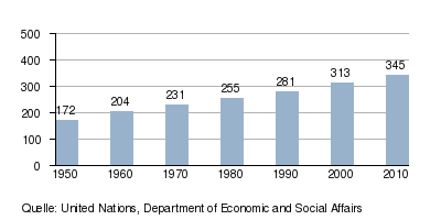
Development of the population of North America (USA and Canada) (in millions)
Indigenous population
Before the discovery and conquest by European nations, North America was already settled by a large number of indigenous ethnic groups who came from Asia in several waves of immigration after the end of the last Ice Age . While the descendants of the last wave (who only settled in the far north) are commonly referred to as Eskimos and Aleutians , the generic term Indian is still popular for everyone else . Canadians also use the term First Nations for all indigenous peoples in the country.
From the beginning of the 16th to the end of the 19th century, countless wars and attempts at assimilation (in part with genocides and ethnocides ) led to a drastic reduction in the indigenous population. Only since the beginning of the 20th century has the population increased again almost everywhere. The proportions compared to the population of European descent are now only very low in the densely populated regions (apart from a few areas of Mexico and Central America). Significant shares up to majority situations can be found above all in the Indian reservations and in extremely sparsely populated wilderness regions .
The adjacent map shows the proportions of indigenous ethnic groups in the total population (based on the respective national census areas ) as well as their territories at the beginning of the 21st century .
economy
The economy of North America comprises more than half a billion people in 23 states and is characterized by the strong differences between the rich countries Canada and the USA , which are among the wealthiest countries in the world, and the poor countries in Central America and the Caribbean ; Mexico , the Bahamas and Costa Rica are in between. Although Mexico is part of NAFTA and the OECD , it is still a lot poorer than its northern neighbors. The Central American states are bound to North America via the DR-CAFTA free trade agreement .
Trade Associations in North America:
- Asia-Pacific Economic Cooperation (APEC) is an economic association of 21 countries worldwide. From North America, Canada, Mexico and the USA are members.
- Caribbean Community (CARICOM) an association of 15 Caribbean states.
- Central American Free Trade Agreement (CAFTA) is a free trade agreement between Costa Rica , the Dominican Republic , El Salvador , Guatemala , Honduras , Nicaragua and the United States .
- North American Free Trade Agreement (NAFTA, North American Free Trade Agreement ) is an extensive trade association between Canada , the USA and Mexico and forms a free trade area .
history

Many North American indigenous peoples were sedentary when they were discovered by the Europeans and already practiced arable and livestock farming extensively , some were hunters and gatherers . After the population of the indigenous people had decimated by around 90% due to a lack of resistance to diseases brought in from Europe and massacres by colonists of the natives, these were so numerically inferior that they could hardly offer any resistance. Many indigenous peoples founded new tribes and associations in response to European settlement . Well-known groups are Wyandot , Mohawk , Apaches , Cherokee , Sioux , Mohegan , Iroquois and Eskimos .
As far as we know today, the first Europeans to reach North America ( Newfoundland ) were the Grænlendingar , who called it Vinland . They reached it around the year 1000. Although they established a few settlements , they left few marks on the continent, as at L'Anse aux Meadows in Newfoundland.

After Christopher Columbus discovered America in 1492, the Spaniards were the first Europeans to stay in southern North America. They soon controlled the large islands of the Caribbean , defeated the Aztecs, and also gained control of Central America and Mexico .
The discovery of North America, more precisely of the later Canada , succeeded the Italian Giovanni Caboto (John Cabot) in the year 1497. While some smaller countries like the Netherlands or Sweden had only smaller possessions on the continent, the continent was between the Spaniards, divided between the French and the English .
The first English settlements were Jamestown and Plymouth Rock , which are now Virginia and Massachusetts . The first French settlements were Port Royal and Québec in the present Canadian provinces of Nova Scotia and Québec .
Regional and political subdivisions

- On the main land mass there are three large and populous states that make up over 85 percent of the total area
| Country | Capital | Details |
|---|---|---|
|
|
Ottawa | Many small islands on the coast of North America belong to Canada, including Vancouver Island and the Haida Gwaii Archipelago in the west, Prince Edward Island , Newfoundland and Cape Breton Island in the east, and the Canadian Arctic Archipelago in the north.
|
|
|
Mexico city | The Revillagigedo Islands and countless smaller islands are part of Mexico. |
|
|
Washington, DC | The 48 contiguous states and Alaska make up most of the United States. They also include Hawaii , whose islands are located far from the continent in the Pacific Ocean and are part of Australia and Oceania .
|
and the dependent islands:
| island | Capital | Details |
|---|---|---|
|
|
Hamilton | A British overseas territory located approximately 1072 km southeast of New York City . |
|
|
Nuuk ( Danish : Godthåb) |
The largest island in the world is a largely autonomous part of the Kingdom of Denmark . |
|
|
Saint-Pierre | a small French local authority consisting of several islands on the south coast of Newfoundland and Labrador (Canada)
|
- At the southern end of the continent, in the relatively small area of Central America , are the following countries
| Country | Capital |
|---|---|
|
|
Belmopan |
|
|
San Jose |
|
|
San Salvador |
|
|
Guatemala City |
|
|
Tegucigalpa |
|
|
Managua |
|
|
Panama City |
- At the southeast end of the continent, in the Caribbean , there are many island states
and the dependent islands and island parts:
1 Panama is included in both North and South America because of the Panama Canal .
2 These islands are located in South America, but are still counted as North America for historical and cultural reasons.
The United States and other English-speaking nations in America are known as Anglo America . Canada is divided into an Anglo-Canadian and a French-Canadian part; the French-speaking part of the largest American country (mostly Québec ) is usually not included in either Anglo or Latin America. The other North and South American nations are grouped under the terms Latin America or Ibero America .
“North America” has different meanings to different people. In everyday Canadian and US American usage, North America mostly refers only to Canada and the United States. Most Mexicans see their country Mexico, however, as part of "North America"; this corresponds to the predominant use of the word in German-speaking science, in international contracting and the like. Ä.
literature
- Sophie Mc Call, Deanna Reder, David Gaertner, Gabrielle Hill Eds .: Read, Listen, Tell. Indigenous Stories from Turtle Island. Wilfrid Laurier University Press 2017
See also
Web links
- July 22, 2019, Jeff Desjardins: visualcapitalist.com: Interactive: How Do Americans Differ by Age? (Interactive age-specific graph of the US population according to various characteristics)
Individual evidence
- ↑ Degree of urbanization (proportion of the urban population in relation to the total population) by continent in 2014 , Statista , accessed on November 14, 2016
- ^ Lenz, Karl (1988): Canada: a geographical country study. Darmstadt: Scientific Book Society .: 39f
- ↑ a b LENZ 1988: 40
- ^ Schneider-Sliwa, Rita (2005): USA. Darmstadt: Scientific Book Society .: 37
- ↑ a b c d SCHNEIDER-SLIWA 2005: 37
- ↑ LENZ 1988: 49
- ↑ Haack Weltatlas 2007, p. 182
- ^ Schneider-Sliwa 2005: 35
- ↑ a b c Schneider-Sliwa 2005: 36
- ↑ LENZ 1988: 51f
- ↑ Lenz 1988: 52
- ↑ Lenz 1988: 53
- ^ Schneider-Sliwa 2005: 36 f.
- ↑ Glaser, Rüdiger and Klaus Kremb (2006): (Eds.): North and South America. Darmstadt: Scientific Book Society .: 34
- ↑ LENZ 1988: 46
- ↑ Lenz 1988: 46 f.
- ↑ LENZ 1988: 47
- ↑ Glaser & Kremb 2006: 28
- ↑ Susan L. Cutter, (2001): American hazardscapes: the regionalization of hazards and disasters. Washington: Joseph Henry Press .: p. 80
- ↑ Christopher C. Burt (2004): Extreme weather: a guide & record book. New York: WW Norton & Company : p. 194
- ↑ BURT 2004: p. 130 f.
- ↑ Annual Summary Atlantic Hurricane Season of 2005 from NOAA's Atlantic Oceanographic and Meteorological Laboratory (AOML). and [1] p. 11
- ↑ Robert E. Davis, Paul C. Knappenberger et al. (2004): Seasonality of climate – human mortality relationships in US cities and impacts of climate change. In: Climate Change , Vol. 26: pp. 61–76, 2004: pp. 61 f.
- ↑ a b Cutter 2001: 79 f.
- ↑ United Nations, Department of Economic and Social Affairs: World Population Prospects: The 2010 Revision , data available online
- ↑ "Turtle Island" is an old Indian name for all of North America.