El Boalo
El Boalo | |
|---|---|
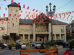
 Town hall of El Boalo | |
 Location of El Boalo in Madrid | |
| Country | |
| Autonomous community | Community of Madrid |
| Area | |
| • Total | 39.59 km2 (15.29 sq mi) |
| Population (2018) | |
| • Total | 7,399 |
| Time zone | UTC+1 (CET) |
| • Summer (DST) | UTC+2 (CEST) |
El Boalo is a Spanish village of around 8200 inhabitants, 52 km (32 mi) north west of Madrid, in the Community of Madrid.
Bus[edit]
- 672: Cerceda - Moralzarzal - Madrid (Moncloa)
- 724: El Boalo - Manzanares el Real - Madrid (Plaza de Castilla)


