Arganda del Rey
| Arganda del Rey parish | ||
|---|---|---|
| coat of arms | Map of Spain | |

|
|
|
| Basic data | ||
| Autonomous Community : | Madrid | |
| Province : | Madrid | |
| Coordinates | 40 ° 18 ′ N , 3 ° 26 ′ W | |
| Height : | 618 msnm | |
| Area : | 79.65 km² | |
| Residents : | 55,389 (Jan 1, 2019) | |
| Population density : | 695.4 inhabitants / km² | |
| Postal code : | 28500 | |
| Municipality number ( INE ): | 28014 | |
| administration | ||
| Website : | www.ayto-arganda.es | |
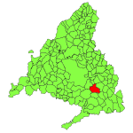
| Location of the municipality | ||

|
||
Arganda del Rey is a Spanish municipality about 20 kilometers southeast of Madrid . It is through the line 9 of the Metro and the R-3 motorway connected to Madrid. It is home to the AD Arganda football club .
Individual evidence
- ↑ Cifras oficiales de población resultantes de la revisión del Padrón municipal a 1 de enero . Population statistics from the Instituto Nacional de Estadística (population update).
