El Escorial
| El Escorial municipality | ||
|---|---|---|
| coat of arms | Map of Spain | |

|
|
|
| Basic data | ||
| Autonomous Community : | Madrid | |
| Province : | Madrid | |
| Comarca : | Cuenca del Guadarrama | |
| Coordinates | 40 ° 35 ′ N , 4 ° 8 ′ W | |
| Height : | 909 msnm | |
| Area : | 68.8 km² | |
| Residents : | 16,162 (Jan 1, 2019) | |
| Population density : | 234.91 inhabitants / km² | |
| Postal code : | E-28280 | |
| Municipality number ( INE ): | 28054 | |
| administration | ||
| Official language : | Castilian | |
| Mayor : | Antonio Vicente Rubio ( PP ) | |
| Website : | www.elescorial.es | |
| Location of the municipality | ||

|
||
El Escorial is a municipality in the north-west of the Spanish autonomous community of Madrid . It is located in the Sierra de Guadarrama and is about 46 kilometers from the capital Madrid .
Culture
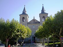
One of the places of interest in the municipality of El Escorial is the Church of St. Barnabas (Iglesia de San Bernabé), built according to King Philip II's wishes based on designs by Francisco de Mora .
The well-known monastery and palace complex Real Sitio de San Lorenzo de El Escorial , which is a UNESCO World Heritage Site , as well as the Franquist Memorial Valle de los Caídos are not located in the municipality of El Escorial, but in the neighboring municipality of San Lorenzo de El Escorial .
Web links
Commons : El Escorial - collection of images, videos and audio files
Individual evidence
- ↑ Cifras oficiales de población resultantes de la revisión del Padrón municipal a 1 de enero . Population statistics from the Instituto Nacional de Estadística (population update).

