Corpa (Madrid)
| Corpa municipality | ||
|---|---|---|
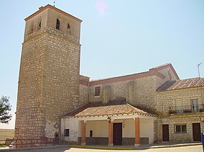
 Corpa - church
|
||
| coat of arms | Map of Spain | |

|
|
|
| Basic data | ||
| Autonomous Community : |
|
|
| Province : | Madrid | |
| Comarca : | Cuenca del Henares | |
| Coordinates | 40 ° 26 ′ N , 3 ° 16 ′ W | |
| Height : | 860 msnm | |
| Area : | 25.91 km² | |
| Residents : | 713 (Jan. 1, 2019) | |
| Population density : | 27.52 inhabitants / km² | |
| Postal code : | 28811 | |
| Municipality number ( INE ): | 28048 | |
| administration | ||
| Website : | Corpa | |
Corpa is a place and a central Spanish rural municipality ( municipio ) with 713 inhabitants (as of January 1 2019) in the east of the Community of Madrid in the transition to the autonomous region of Castile-La Mancha . The municipality belongs to the cultural landscape of the Alcarria .
Location and climate
The village of Corpa, located about 860 m above sea level, is located in the Iberian Highlands ( Meseta ) southeast of the Castilian Scheidegebirge . The Spanish capital Madrid is just 40 km to the west; the town of Alcalá de Henares is about 17 km to the northwest. The climate in winter is temperate, while in summer it is warm to hot; the rather low amounts of precipitation (approx. 450 mm / year) fall - with the exception of the almost rainless summer months - distributed over the whole year.
Population development
| year | 1857 | 1900 | 1950 | 2001 | 2019 |
| Residents | 543 | 609 | 569 | 418 | 713 |
The place in the east of the Madrid region - unlike many places in the area - has largely retained its character as a rural community with a stable population.
economy
Torres de la Alameda was dominated by agriculture for centuries; the people lived largely as a self-sufficient source of income from the surrounding fields and house gardens.
history
So far, no finds from the Celtic , Roman and Visigothic periods have been discovered in the municipality . In the 8th century the area was devastated by Moorish armies. In 1118 troops of the Archbishop of Toledo took the fortress of Alcalá as part of the Reconquista ; his successor received the region from the king as a fief and the phase of repopulation or repopulation ( repoblación ) began . In 1578 the fiefdom reverted to the Spanish crown, but Philip II sold it to one of his followers.
Attractions
- The Plaza de la Constitución is the center of the place; here are the town hall (ayuntamiento) and the Palacio de los Marqueses de Mondéjar, which has not been used for a long time, with its two corner towers and the simple columned portal.
- The Iglesia de Santo Domingo de Silos originally dates from the 12th / 13th centuries. Century. However, it was partially destroyed during the Spanish Civil War (1936–1939) and only rebuilt in 1951.
- At the cemetery (cementerio) is the Ermita del Cristo de la Piedad , which was also destroyed during the civil war but was later largely rebuilt .
Web links
Individual evidence
- ↑ Cifras oficiales de población resultantes de la revisión del Padrón municipal a 1 de enero . Population statistics from the Instituto Nacional de Estadística (population update).
- ↑ Corpa / Madrid - climate tables
- ^ Corpa - population development
- ^ Corpa history
- ↑ Corpa - palace
- ^ Corpa - Church
- ^ Corpa - Ermita

