Galapagar
| Galapagar parish | ||
|---|---|---|
 Galapagar - Monument to Jacinto Benavente and church
|
||
| coat of arms | Map of Spain | |

|
|
|
| Basic data | ||
| Autonomous Community : | Madrid | |
| Province : | Madrid | |
| Comarca : | Cuenca del Guadarrama | |
| Coordinates | 40 ° 35 ′ N , 4 ° 0 ′ W | |
| Height : | 880 msnm | |
| Area : | 64.99 km² | |
| Residents : | 33,742 (Jan 1, 2019) | |
| Population density : | 519.19 inhabitants / km² | |
| Postal code : | 28260 | |
| Municipality number ( INE ): | 28061 | |
| administration | ||
| Website : | Galapagar | |
Galapagar is a central Spanish city and a mountain community ( municipio ) with 33,742 inhabitants (as of January 1, 2019) in the northwest of the autonomous community of Madrid . The place name comes from a colony of turtles that supposedly lived nearby in earlier times (Galapagos , city arms).
Location and climate
The mountain village of Galapagar is located in the southern foothills of the Sierra de Guadarrama a good 36 km northwest of the city of Madrid at an altitude of approx. 880 m ; the monastery palace of the Escorial is only about 11 km to the west. The climate in winter is cool, whereas in summer it is temperate to warm; Precipitation - sometimes in the form of snow - (approx. 450 mm / year) mainly falls in the winter half-year.
Population development
| year | 1857 | 1900 | 1950 | 2000 | 2018 |
| Residents | 951 | 894 | 1,647 | 21,807 | 33,379 |
The population increase that has been recorded since the beginning of the 20th century is mainly due to the relative proximity to the greater Madrid area and the increasing tourism within Spain.
economy
In earlier times the area served as summer pasture for the herds of cattle, some of which came from far away. Apart from that, the inhabitants of the place, like the entire mountain region, lived almost without exception as self-sufficiency from the yields of their fields and house gardens; cattle breeding was also practiced. With the improvement of the traffic conditions (railway connection, buses) since the 1850s and especially since the middle of the 19th century, the place has become more and more popular as a climatic health resort and summer resort .
history
The Celts , Romans , Visigoths and Moors left hardly any traces; a Roman road coming from Titulcia and leading over the Fuenfría Pass to Segovia ran through what is now the municipality. The place was probably founded in the late Middle Ages; During the construction of the Escorial it was often used as a resting place for the king and his court.
Attractions
- The Iglesia de San Bartolomé dates from 1447; However, it was modernized several times in later times.
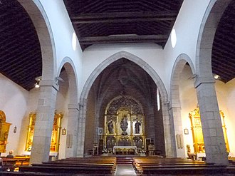
- The originally single nave Iglesia de Nuestra Señora de la Asunción dates from the 16th century; the two aisles were added about a century later. While the apse a late Gothic vault has to be three naves (naves) of a wooden roof spans. The ensemble of several carved altars (retablos) is impressive .
- The old town hall rises in the center of the old town and dates from the 19th century.
- The Centro Cultural La Pocilla , built in a modern style after 2015 in a new district about 2 km northwest of the old town, contains a theater and a library.
- Surroundings
- About 3 km northeast of the village, the single-arched medieval Puente de la Alcanzorla spans the Río Guadarrama .
- About 5 km southeast is the unfinished, but still preserved Presa de El Gasco dam from the 18th century.
Web links
- Galapagar, sights - photo + information (Spanish)
Individual evidence
- ↑ Cifras oficiales de población resultantes de la revisión del Padrón municipal a 1 de enero . Population statistics from the Instituto Nacional de Estadística (population update).
- ↑ Galapagar - climate tables
- ↑ Galapagar - population development
- ↑ Galapagar History
- ↑ Galapagar Church

