Talamanca de Jarama
| Talamanca de Jarama municipality | ||
|---|---|---|

Atalaya El Vellon near Talamanca de Jarama
|
||
| coat of arms | Map of Spain | |

|
|
|
| Basic data | ||
| Autonomous Community : | Madrid | |
| Province : | Madrid | |
| Coordinates | 40 ° 45 ′ N , 3 ° 30 ′ W | |
| Height : | 654 msnm | |
| Area : | 39.36 km² | |
| Residents : | 3,857 (Jan 1, 2019) | |
| Population density : | 97.99 inhabitants / km² | |
| Postal code : | 28160 | |
| Municipality number ( INE ): | 28145 | |
| administration | ||
| Website : | www.talamancadejarama.org | |
Talamanca de Jarama is a place and a municipality ( municipio ) with 3857 inhabitants (as of January 1, 2019) in the autonomous community of Madrid in central Spain . The old town center was classified as a cultural asset ( Bien de Interés Cultural ) in the Conjunto histórico-artístico category because of its historical buildings .
Location and traffic
Talamanca de Jarama lies at an altitude of approx. 650 meters above sea level. d. M. about 53 kilometers northeast of the city of Madrid on the Río Jarama . The city of Guadalajara in the province of the same name is located almost 40 kilometers southeast. Toledo , the old capital of Spain, is about 130 kilometers to the south-west.
Population development
| year | 1960 | 1970 | 1981 | 1991 | 2001 | 2012 |
| Residents | 724 | 783 | 888 | 1,100 | 1,658 | 3,178 |
In the 19th century the population was consistently around 500 people. Comparatively low property prices and rents have led to an influx of people from rural areas, but also from the city of Madrid, in recent years.
economy
For a long time Talamanca de Jarama was a medium-sized handicraft and market center north of Madrid, which was essentially characterized by an agricultural self-sufficiency economy. Since the 1960s tourism has been added as a source of income for the place.
history
The history of Talamanca de Jarama goes back to the Bronze and Iron Ages ; at that time the area was populated by Celtic or Celtiberian tribal groups. A necropolis discovered in the area dates from this period . In Roman times, the place was at the intersection of two smaller streets, which favored the establishment of a settlement: the so-called Roman bridge ( puente romano ) over the Río Jarama probably dates from this time . The place was also populated in the Visigothic period. Most traces of the period of Islamic dominance ( Al-Andalus ) over large parts of the Iberian Peninsula have disappeared; On a mountain range north of Talamanca, however, there are still some round watch and signal towers ( atalayas ), which belong to a Muslim line of defense about 100 kilometers north of Toledo and date to the 9th or 10th century. Furthermore, a chronicler by the name of Umar Al-Talamankí (951-1038) is known.

In the years 1083-1085 fell in connection with the reconquest ( reconquista ) Toledos by Alfonso VI. also Talamanca again in Christian hands. In 1140 Alfonso VII gave Talamanca and its surrounding area into the hands of his lover Urraca Fernández de Castro ; In 1188 Alfonso VIII entrusted the manorial rule ( señorio ) over Talamanca to the diocese of Toledo . A few years later, after the defeat of Alfonso VIII's troops in the Battle of Alarcos (1195), Talamarca again fell into the hands of the Muslims for a short time - a situation that occurred after the battle of Las Navas de Tolosa , which was victorious for the Christian armies ( 1212) has been corrected forever. In the 13th century Talamanca experienced an economic and cultural heyday, which can be seen above all in connection with the repopulation ( repoblación ) of the region by newcomers from the north but also from the south of Spain ( mudéjares ). During this time, the Ábside de los Milagros , an impressive Romanesque brick building in the Mudéjar style, was built .
In the 15th century, the place had around 2,500 inhabitants - a number that fell to around 400 after the expulsion of the Jews from Spain in the years after 1492 until the middle of the 16th century. Finally - especially after the moriscos were expelled (1610) - it sank back to the status of a rural community that could or had to support itself on the principle of self-sufficiency from farming and cattle breeding. From the 16th to the 18th century, the city changed its landlord several times; last heard the region substantially to the Carthusian order and the Dukes of Béjar , which in 1520 by Charles V to the grandees were counted first class.
After the - brief - abolition of all manorials in the liberal constitution of Cádiz (1812) and the reorganization of the Spanish national territory in 1833, Talamanca came to the province of Madrid . Shortly afterwards almost all church property was nationalized as part of the desamortisación . During the Spanish Civil War , Talamanca briefly once again became a border town between the two opposing camps.
Attractions
- Of the five medieval churches of Talamanca only two have been preserved in parts: the Romanesque apse of the Church of San Juan Bautista is the oldest preserved building in the city; The semicircle, built from precisely hewn house stones, is vertically structured by four three-quarter columns and has three - formerly probably unglazed - narrow window slots with inserted columns. The consoles below the eaves used to be decorated with heads and small figures; the metope fields in between showed a rich geometric ornamentation. The rest of the church is essentially from the 16th century.
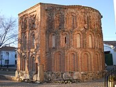
- The Ábside de los Milagros , built entirely of brick in the Mudéjar style , is usually just called El Morabito and is only a little younger. The outside shows a three-storey structure of staggered blind arcades , which hardly differ in size from one another, above a base of large, largely unhewn boulders . The interior, however, is only two-story; the apse dome made of brick is hidden behind the upper arcade zone of the outer building. Striking, but common in Mudejar-style buildings, is the complete lack of figurative or vegetal decorative elements.
- Two rather inconspicuous city gates ( Puerta Sur and Puerta del Este ), three flank towers and several short sections of the wall have been preserved from the medieval city wall, which was later repeatedly repaired and partly renewed .
- The former Carthusian monastery ( cartuja ) dates from the 17th century; the parts that have been preserved are kept remarkably simple - as is the case with the brick construction used here. The monks living here, in contrast to their urban colleagues, turned back to agricultural work and refused to decorate the monastery - so the overall look of the building complex is more like a rural estate. The premises include a brick-vaulted, semi-above-ground cellar ( bodega ) and a small chapel with frescoes.
- In the northwest of the old town is the small hermit church ( ermita ) La Soledad from the 17th century.
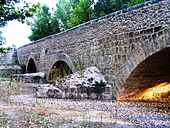
- A stone five- arch segment arch bridge over the former river bed of the Río Jarama is - due to its technically solid stone work in the lower part - still dated to the Roman period, but this is rather unlikely because of the wide arches. The side parapets with their broken stone and pebble stone walls certainly date back to medieval times.
- Atalayas
- Several round towers ( atalayas ) made of uncut natural stone or their ruins, which were built in the 9th and 10th centuries during the period of Islamic rule, as watchtowers and signal towers, stand on a mountain range about 1000 meters high a few kilometers north of Talamanca . The most impressive is near the hamlet of El Vellon ; with a diameter of about six meters, its walls about one meter thick reach a height of about nine meters. The access to the tower is at a height of 2.50 meters and could only be reached by means of a ladder, which could be retracted in the event of a defense. Inside, too, the wooden viewing platform could only be reached via a ladder.
- The Atalaya Arrebatacapas near Torrelaguna is somewhat larger in size and height but otherwise identical in structure .
- The Atalaya Torrepedrera near the hamlet of El Berrueco is slightly smaller in size and height .
Movies
Talamanca de Jarama and some buildings in the city have served as a backdrop for many film productions; the most important are:
- Conan the Barbarian (1982); Director: John Milius , leading actor: Arnold Schwarzenegger
- 1492 - The Conquest of Paradise (1992); Director: Ridley Scott , leading actor: Gérard Depardieu
- Farinelli (1994); Direction: Gérard Corbiau , leading actor: Stefano Dionisi
- Goya's Spirits (2006); Direction: Miloš Forman , leading actor: Stellan Skarsgård
- Alatriste (2006); Direction: Agustín Díaz Yanes , leading actor: Viggo Mortensen
Town twinning
- Talamanca (Cantón), Costa Rica
Personalities
- Umar Al-Talamankí (951-1038), Islamic chronicler and Koran scholar
Web links
- Talamanca de Jarama, historical buildings - photos + information (Spanish)
- Talamanca de Jarama, historical buildings - photos + information (Spanish)
- Talamanca de Jarama - Photos
- Talamanca de Jarama, city wall - photos + information (Spanish)
Individual evidence
- ↑ Cifras oficiales de población resultantes de la revisión del Padrón municipal a 1 de enero . Population statistics from the Instituto Nacional de Estadística (population update).


