Alata
| Alata | ||
|---|---|---|
|
|
||
| region | Corsica | |
| Department | Corse-du-Sud | |
| Arrondissement | Ajaccio | |
| Canton | Ajaccio-5 | |
| Community association | Pays Ajaccien | |
| Coordinates | 41 ° 59 ′ N , 8 ° 45 ′ E | |
| height | 0-782 m | |
| surface | 30.37 km 2 | |
| Residents | 3,244 (January 1, 2017) | |
| Population density | 107 inhabitants / km 2 | |
| Post Code | 20167 | |
| INSEE code | 2A006 | |
| Website | http://www.mairie-alata.fr/index.php | |
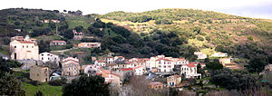
 View of Alata |
||
Alata is a French commune in the southern part of the island of Corsica with 3,244 inhabitants (as of January 1, 2017) in the Corse-du-Sud department . Alata belongs to the Arrondissement of Ajaccio and the Canton of Ajaccio-5 . The inhabitants are called Alatais .
geography
Alata is about seven kilometers north of Ajaccio on the Gulf of Lava ( Mediterranean Sea ). Alata is surrounded by the neighboring communities of Appietto in the north, Afa in the east, Ajaccio in the south and Villanova in the west and southwest.
The municipality is located in the Ajaccio wine region .
history
The community was founded in 1862.
Population development
| 1962 | 1968 | 1975 | 1982 | 1990 | 1999 | 2006 | 2012 |
|---|---|---|---|---|---|---|---|
| 391 | 410 | 452 | 1,132 | 2,077 | 2,459 | 2,820 | 3,076 |
Attractions
- La Punta Castle, mansion from the 19th century, monument historique since 1970/77
- 19th century burial chapel of the Pozzo di Borgo family, Monument historique
- Saint-Pierre-et-Saint-Paul church with tabernacle
- Saint-Pierre-aux-Liens church with tabernacle
- Marina on the Gulf of Lava
Personalities
- Carlo Andrea Pozzo di Borgo (1764–1842), politician and diplomat
Web links
Commons : Alata - collection of images, videos and audio files

