
Coti-Chiavari
|
Coti-Chiavari Coti è Chjavari |
||
|---|---|---|
|
||
| region | Corsica | |
| Department | Corse-du-Sud | |
| Arrondissement | Ajaccio | |
| Canton | Taravo-Ornano | |
| Community association | Pieve de l'Ornano | |
| Coordinates | 41 ° 46 ′ N , 8 ° 46 ′ E | |
| height | 0-648 m | |
| surface | 63.33 km 2 | |
| Residents | 728 (January 1, 2017) | |
| Population density | 11 inhabitants / km 2 | |
| Post Code | 20138 | |
| INSEE code | 2A098 | |

Coti-Chiavari ( Corsican Coti è Chjavari ) is a municipality on the Mediterranean island of Corsica . It belongs to the Corse-du-Sud department , the Ajaccio arrondissement and the Taravo-Ornano canton .
geography
Coti-Chiavari is located in the southwest of the island and borders the Mediterranean Sea and the municipalities of Pietrosella in the north, Cognocoli-Monticchi (point of contact) in the northeast and Serra-di-Ferro in the southwest. The settlement area is 614 meters above sea level and consists of the villages Coti-Chiavari, Acqua Doria, Agnone, Pozzaccio, Portigliolo, Ariezza, Cardo, Cala-di-Ciglio, Campestra, Erba Mora, Verghia, Figone, Cantone, Cala d 'Orzu, Piobarello, Monte Bianco, Piosella, A Castagna, Paccialella, Scopiccia, Murmontagia and Stéfanaccia.
Population development
| year | 1962 | 1968 | 1975 | 1982 | 1990 | 1999 | 2008 | 2012 |
|---|---|---|---|---|---|---|---|---|
| Residents | 259 | 270 | 285 | 340 | 399 | 490 | 733 | 737 |
Attractions
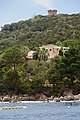
- Genoese towers Tour de Capo-Nero ( Corsican Tour de Capu-Neru) and Tour de la Castagna
- Former police station
- Former barracks
- Saint-Jean-Baptiste church
- Funéraire chapels of the Murzi and Sainte-Marie families
- The mast of the transmitter Coti-Chiavari is also characteristic of the site .

Genoese tower Capo-Nero on the Gulf of Valinco
Genoese tower Tour de la Castagna
.jpg)
