
Sarrola-Carcopino
|
Sarrola-Carcopino Sarrula è Carcupinu |
||
|---|---|---|
|
||
| region | Corsica | |
| Department | Corse-du-Sud | |
| Arrondissement | Ajaccio | |
| Canton | Gravona-Prunelli | |
| Community association | Pays Ajaccien | |
| Coordinates | 42 ° 2 ′ N , 8 ° 51 ′ E | |
| height | 15-1,133 m | |
| surface | 27.01 km 2 | |
| Residents | 3,267 (January 1, 2017) | |
| Population density | 121 inhabitants / km 2 | |
| Post Code | 20167 | |
| INSEE code | 2A271 | |

Sarrola-Carcopino ( Corsican Sarrula è Carcupinu ) is a municipality on the French Mediterranean island of Corsica . It belongs to the Corse-du-Sud department , the Ajaccio arrondissement and the Gravona-Prunelli canton .
Geography and infrastructure
The Route nationale 849 led over Sarrola-Carcopino and then over the at 376 m. ü. M. located mountain pass Col d'Ambiegna to Ambiegna .
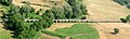
The village is served by the Chemins de fer de la Corse railway company through the Mezzana train station .
Neighboring communities are Valle-di-Mezzana in the north, Tavaco in the northeast, Peri in the east, Cuttoli-Corticchiato in the southeast, Afa in the southwest and Appietto in the west.
economy
Sarrola-Carcopino is one of the 36 municipalities with approved vineyards in the Ajaccio wine-growing region .

Mezzana station with a freight train hauled by a diesel locomotive
The Mezzana Aqueduct

history
The municipality used to be called "Sarrola". Part of the district went to the Afa community founded in 1852 .
Population development
| year | 1962 | 1968 | 1975 | 1982 | 1990 | 1999 | 2008 | 2012 |
|---|---|---|---|---|---|---|---|---|
| Residents | 511 | 534 | 508 | 812 | 1424 | 1801 | 1927 | 2219 |