
Bastelica
| Bastelica | ||
|---|---|---|
|
||
| region | Corsica | |
| Department | Corse-du-Sud | |
| Arrondissement | Ajaccio | |
| Canton | Gravona-Prunelli | |
| Community association | Celavu-Prunelli | |
| Coordinates | 42 ° 0 ′ N , 9 ° 3 ′ E | |
| height | 290-2,352 m | |
| surface | 127.69 km 2 | |
| Residents | 533 (January 1, 2017) | |
| Population density | 4 inhabitants / km 2 | |
| Post Code | 20119 | |
| INSEE code | 2A031 | |
 Bastelica |
||

Bastelica is a municipality on the Mediterranean island of Corsica in France . It belongs to the Corse-du-Sud department , the Ajaccio arrondissement and the Gravona-Prunelli canton .
Geography and infrastructure
The village center is 808 meters above sea level. To the northeast of Bastelica on the Plateau d'Ese there are relatively small ski areas with a few drag lifts . The neighboring municipalities are Ucciani , Tavera and Bocognano in the northwest, Ghisoni in the northeast, Palneca , Ciamannacce and Tasso in the east, Guitera-les-Bains , Frasseto and Quasquara in the southeast, Azilone-Ampaza in the south, Cauro and Eccica-Suarella in the southwest as well Tolla and Peri in the west.
Personalities
- Sampiero Corso , nobleman and freedom fighter
Attractions
- Bastelica is the starting point for many hikes, for example up to Lac de Vitelca along the upper reaches of the Prunelli.
- Genoese bridge "Pont de Zippitoli", a monument historique
- Statue of Sampiero Corso
- Genoese tower Tour de Capiteddu , Monument historique

Genoese bridge Pont de Zipitoli
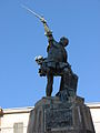
Statue of Sampiero Corso
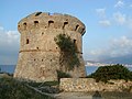
Genoese tower Tour de Capiteddu

Saint-Michel church


Population development
| year | 1962 | 1968 | 1975 | 1982 | 1990 | 1999 | 2008 | 2012 | 2017 |
|---|---|---|---|---|---|---|---|---|---|
| Residents | 833 | 774 | 762 | 766 | 436 | 460 | 531 | 537 | 533 |
Web links
Individual evidence
- ↑ Chalet du Val d'Ese , accessed on May 8, 2020.
- ↑ Lac de Vitalaca. In: Corse-randos.com. February 27, 2018, accessed on May 12, 2018 (fr-fr).