
Allons (Lot-et-Garonne)
|
Allons Alon |
||
|---|---|---|
|
||
| region | Nouvelle-Aquitaine | |
| Department | Lot-et-Garonne | |
| Arrondissement | Nérac | |
| Canton | Les Forêts de Gascogne | |
| Community association | Coteaux et Landes de Gascogne | |
| Coordinates | 44 ° 12 ′ N , 0 ° 3 ′ W | |
| height | 98-156 m | |
| surface | 76.33 km 2 | |
| Residents | 165 (January 1, 2017) | |
| Population density | 2 inhabitants / km 2 | |
| Post Code | 47420 | |
| INSEE code | 47007 | |
 Town Hall (Mairie) of Allons |
||

Allons ( Occitan : Alon ) is a French municipality with 165 inhabitants (as of January 1 2017) in the department of Lot-et-Garonne in the region Nouvelle-Aquitaine (before 2016: Aquitaine ). The municipality belongs to the Arrondissement Nérac and the canton Les Forêts de Gascogne (until 2015: Canton Houeillès ). The inhabitants are called Allonais .
geography
Allons is the westernmost municipality in the Lot-et-Garonne department. It is located about 53 kilometers west of Agen . Allons is surrounded by the neighboring communities of Lartigue in the north, Pindères in the northeast, Sauméjan in the east and northeast, Houeillès in the east, Lubbon in the southeast, Losse in the south, Maillas in the west and Giscos in the northwest.
Population development
| year | 1962 | 1968 | 1975 | 1982 | 1990 | 1999 | 2006 | 2013 |
| Residents | 304 | 247 | 185 | 152 | 152 | 172 | 174 | 175 |
| Source: Cassini and INSEE | ||||||||
Attractions
- Saint-Christophe church from the 17th century
- Saint Clair church in Gouts from the 13th century, historic monument since 1995
- Notre-Dame-de-Lubans church from the 14th century
- Fortified house of Capchicot, Monument historique since 1998
- House Luxurguey, Monument historique since 1993
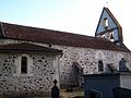
Saint-Christophe Church

Saint Clair Church

Fortified house of Capchicot


