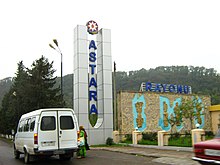
Astara (Rayon)
Astara is a rayon in Azerbaijan . It borders on Iran to the south and west and the Caspian Sea to the east . The capital is Astara .
geography
The rayon has an area of 616 km². In the west lies the Talysh Mountains with a height of up to 2000 meters. The east of the region extends part of the Lenkoran lowlands . Much of the area is forested. The Astarachai and Tengerud rivers flow through the rayon into the Caspian Sea. Part of the Hirkan National Park is located in the district.
population
In 2009, 95,900 people lived in the rayon. The population is distributed over a city and 13 villages. A large part of the population are Talysh , who follow Shiite Islam . Also, Azerbaijanis and Russians live in the district .
economy
Mainly tea, cereals, citrus fruits and vegetables are grown in the region. There is also a food processing industry in the capital, Astara. The pipeline from Abadan on the Persian Gulf to Azerbaijan runs through the district .
Attractions
In the village of Şahağac there is a mausoleum from the 12th century. In Ərcihan there is the Kərbəlayi Həmid Abdulla Hamamı mosque . There are hot springs in Isti-Su. There is also a caravanserai from the 7th century and stone-age sculptures in the districts of Siniyapert, Lomin and Pileken.
Individual evidence
- ↑ a b c Azerbaijan Development Gateway ( Memento of November 14, 2008 in the Internet Archive ) about the rayon
- ↑ a b c azerb.com about the rayon and the city
- ↑ Azerbaijani Statistical Authority ( Memento of November 14, 2010 in the Internet Archive )
Web links
Coordinates: 38 ° 30 ' N , 48 ° 42' E

