Aurec-sur-Loire
| Aurec-sur-Loire | ||
|---|---|---|

|
|
|
| region | Auvergne-Rhône-Alpes | |
| Department | Haute Loire | |
| Arrondissement | Yssingeaux | |
| Canton | Aurec-sur-Loire (main town) | |
| Community association | Loire et Semène | |
| Coordinates | 45 ° 22 ′ N , 4 ° 12 ′ E | |
| height | 414-821 m | |
| surface | 22.44 km 2 | |
| Residents | 6,111 (January 1, 2017) | |
| Population density | 272 inhabitants / km 2 | |
| Post Code | 43110 | |
| INSEE code | 43012 | |
| Website | http://www.mairie-aurec.com/ | |
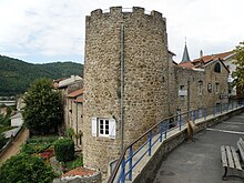
 View of Aurec-sur-Loire |
||
Aurec-sur-Loire is a commune with 6111 inhabitants (as of January 1 2017) in the department of Haute-Loire in the region Auvergne Rhône-Alpes . It belongs to the arrondissement of Yssingeaux and is the main town (French: chef-lieu ) of the canton of Aurec-sur-Loire .
geography
Aurec-sur-Loire is located - according to its name - on the Loire , into which the Semène flows here on the edge of the Monts du Forez . Aurec-sur-Loire is surrounded by the neighboring communities of Saint-Maurice-en-Gourgois in the north, Saint-Paul-en-Comillon in the northeast, Saint-Ferréol-d'Auroure in the east, Pont-Salomon in the southeast, La Chapelle-d 'Aurec in the south and Malvalette in the west.
Attractions
- Château seigneurial , built in the 11th century, with additions from the 13th and 15th centuries, Monument historique
- Château du moine sacristain , today's wine museum
- Château de Chazournes
- Remains of a Roman bridge over the Loire
- Saint-Pierre church from the 12th century
- Tower d'Oriol
Web links
Commons : Aurec-sur-Loire - Collection of images, videos and audio files
Wiktionary: Aurec-sur-Loire - explanations of meanings, word origins, synonyms, translations


