Saint-Didier-en-Velay
| Saint-Didier-en-Velay | ||
|---|---|---|

|
|
|
| region | Auvergne-Rhône-Alpes | |
| Department | Haute Loire | |
| Arrondissement | Yssingeaux | |
| Canton | Deux Rivières et Vallées | |
| Community association | Loire et Semène | |
| Coordinates | 45 ° 18 ′ N , 4 ° 17 ′ E | |
| height | 640-924 m | |
| surface | 25.56 km 2 | |
| Residents | 3,403 (January 1, 2017) | |
| Population density | 133 inhabitants / km 2 | |
| Post Code | 43140 | |
| INSEE code | 43177 | |
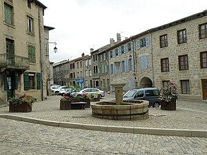
 The Grande Place in Saint-Didier-en-Velay |
||
Saint-Didier-en-Velay is a French municipality with 3403 inhabitants (at January 1, 2017) in the department of Haute-Loire in the region Auvergne Rhône-Alpes . It belongs to the arrondissement of Yssingeaux and the canton of Deux Rivières et Vallées .
geography
The municipality is located in the Velay , a landscape in the French Massif Central , around 40 kilometers northeast of Le Puy-en-Velay and 17 kilometers southwest of Saint-Étienne . The neighboring municipalities of Saint-Didier-en-Velay are:
- Saint-Ferréol-d'Auroure in the north,
- Saint-Just-Malmont in the northeast,
- Saint-Victor-Malescours in the east,
- Saint-Pal-de-Mons and Sainte-Sigolène in the south,
- La Séauve-sur-Semène to the west and
- Pont-Salomon in the northwest.
Saint-Didier-en-Velay is located in the catchment area of the Semène River , which drains to the Loire in a north-westerly direction .
Transport links
The municipal area is served by the D500 departmental road, the national road 88 runs west of the municipality, about four kilometers away.
Population development
| year | 1968 | 1975 | 1982 | 1990 | 1999 | 2009 | 2016 |
| Residents | 2555 | 2422 | 2580 | 2723 | 2891 | 3313 | 3425 |
Attractions
- Église Saint-Didier from the 12th century, Monument historique
Web links
Individual evidence
- ↑ Église Saint-Didier in the Base Mérimée of the French Ministry of Culture (French)
