Saint-Jeures
| Saint-Jeures | ||
|---|---|---|
|
|
||
| region | Auvergne-Rhône-Alpes | |
| Department | Haute Loire | |
| Arrondissement | Yssingeaux | |
| Canton | Boutières | |
| Community association | Haut-Lignon | |
| Coordinates | 45 ° 6 ′ N , 4 ° 12 ′ E | |
| height | 749-1,208 m | |
| surface | 34.14 km 2 | |
| Residents | 964 (January 1, 2017) | |
| Population density | 28 inhabitants / km 2 | |
| Post Code | 43200 | |
| INSEE code | 43199 | |
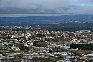
 View of Saint-Jeures |
||
Saint-Jeures is a French municipality with 964 inhabitants (as of January 1 2017) in the department of Haute-Loire in the region Auvergne Rhône-Alpes . The municipality belongs to the arrondissement of Yssingeaux and the canton of Boutières (until 2015: canton Tence ).
geography
Saint-Jeures is about 25 kilometers east-northeast of Le Puy-en-Velay . Saint-Jeures is surrounded by the neighboring communities of Grazac and Lapte in the north, Chenereilles in the north-east, Tence in the east, Mazet-Saint-Voy in the south and south-east, Araules in the south and south-west and Yssingeaux in the west and north-west.
Population development
| year | 1962 | 1968 | 1975 | 1982 | 1990 | 1999 | 2006 | 2013 |
| Residents | 1,164 | 1,059 | 917 | 775 | 767 | 782 | 863 | 951 |
| Source: Cassini and INSEE | ||||||||
Attractions
- Menhir
- Protestant church, built 1872/1873
- Les Changheas Castle from the 16th century, Monument historique from 1997
- Salcrupt Castle
Personalities
- Mathieu Jouve Jourdan (1746–1794), revolutionary
- Philippe Vocanson (1904–2015), oldest person in France (sometimes also in Europe)
Web links
Commons : Saint-Jeures - Collection of images, videos and audio files
