
Brunn (unincorporated area)

The municipality-free area of Brunn is located in the central Franconian district of Nürnberger Land in Bavaria .
description
The 10.18 km² large state forest is the northwest of Brunn and west of Leinburg and Winkelhaid part of the Lorenzer Reichswald . The A3 and A9 motorways run through the area and form the Nuremberg motorway junction with the Haimendorfer Forest on its northern border . The Brunner Berg is 438 m above sea level. NHN the highest elevation.
A large part is part of the EU bird sanctuary area Nuremberg Reichswald .
Waters
The eastern part of the area is traversed by the Röthenbach . The left upper course Zweibrücklesgraben of the Schneidersbach arises in the state forest of Brunn from the two source brooks Erlgraben and Höllgraben , which on the north slope of the von Brunner Berg ( 438 m above sea level ) in the east to a knoll at the Rote Marter (approx. 386 m above sea level) ) arise in the west of the ridge of the hill. The Luderbach flows into the southeastern area, the Haidelbach further north between the A3 on the left and a sand pit on the right edge of the Röthenbach.
After leaving the municipality of Leinburg, the two branches reunite, the stream then takes on the Schmidgraben (Gänsebühlbach) from the right and then flows straight to 339.8 m above sea level. NHN in the community-free Brunner Staatsforst between the A 3 on the left and a sand pit on the right edge from the left into the Röthenbach.
Worth seeing
The forest is criss-crossed by a few cycling and hiking trails. The Franconian Dune Trail also crosses the area. The Original Valley is on the eastern border .
Water tower

North of Brunn, somewhat hidden in the forest, there is a small water tower ( 49 ° 26 ′ 41.78 ″ N , 11 ° 14 ′ 52.22 ″ E ). The slender and around 7 meter high tower is part of a 200- capacity elevated tank and has been part of the Brunner water supply since 1961. The water comes from the Krämersweiher waterworks , which went into operation in 1893 and is fed by four wells up to 148 meters deep.

Frog stone
To the west of Brunn am Brunner Weg is the Froschstein ( 49 ° 26 ′ 16.93 ″ N , 11 ° 12 ′ 45.05 ″ E ). The boulder, made of castle sandstone , is about 5 meters long, 3 meters wide and 2 meters high. It owes its name to its strange shape, which looks like a frog when viewed from the north . There are carvings of an elephant on the rock .
Brunn Castle
To the west of Brunn ( 49 ° 26 ′ 10.03 ″ N , 11 ° 14 ′ 48.8 ″ E ) are the remains of the now defunct Brunn Castle . It is also called the Brunn Hunting Lodge . The complex was first mentioned in 1347 and served the emperors and kings as a hunting lodge during their stays in Nuremberg. The hunting lodge was destroyed in 1449 during the First Margrave War. Today only a few remains of the wall and trenches are visible.
See also
- List of unincorporated areas in Bavaria
- List of soil monuments in Brunn (unincorporated area)
- List of rivers in the Pegnitz river system
Picture gallery
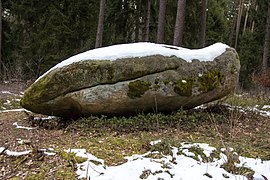
The frog stone

Incisions on the frog stone
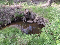
The Schneidersbach in the state forest of Brunn

Schneidersbach source

Remnants of the wall of the abandoned Brunn Castle


Individual evidence
- ↑ Area information at www.destatis.de, as of December 31, 2018 , accessed on August 1, 2020.
- ↑ www.protectedplanet.net, Nürnberger Reichswald (accessed on August 5, 2016)
- ↑ 6533-471 Nuremberg Reichswald. (EU bird sanctuary) Profiles of the Natura 2000 areas. Published by the Federal Agency for Nature Conservation . Retrieved November 27, 2017.
- ^ Bavarian State Forests, Monuments in the Nuremberg Reichswald (accessed on August 1, 2017)
- ↑ BayernAtlas, Lage des Froschstein (accessed on August 1, 2017)
Web links
- Brunn, community-free area in OpenStreetMap (accessed on August 5, 2016)

Alfeld | Altdorf near Nuremberg | Burgthann | Engelthal | Damp | Happurg | Hartenstein | Henfenfeld | Hersbruck | Kirchensittenbach | Lauf an der Pegnitz | Leinburg | Neuhaus an der Pegnitz | Neunkirchen am Sand | Offenhausen | Ottensoos | Pommelsbrunn | Reichenschwand | Röthenbach an der Pegnitz | Rückersdorf | Schnaittach | Schwaig near Nuremberg | Schwarzenbruck | Simmelsdorf | Velden | Provision | Winkelhaid
Unregulated areas:
Behringersdorfer Forst |
Brunn |
Engelthaler Forest |
Moist forest |
Fischbach |
Forsthof |
Günthersbühler Forest |
Haimendorfer Forest |
Laufamholzer Forest |
Leinburg |
Rückersdorfer Forst |
Schoenberg |
Winkelhaid |
Zerzabelshofer Forest
Coordinates: 49 ° 26 ′ 13 ″ N , 11 ° 14 ′ 16 ″ E