Des Moines (Washington)
| Des Moines | |
|---|---|
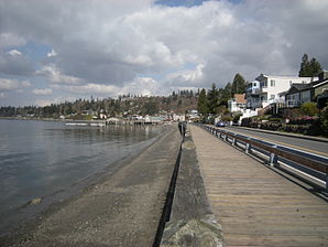
 View of Des Moines |
|
| Location in Washington | |
| Basic data | |
| Foundation : | June 17, 1959 |
| State : | United States |
| State : | Washington |
| County : | King County |
| Coordinates : | 47 ° 24 ′ N , 122 ° 19 ′ W |
| Time zone : | Pacific ( UTC − 8 / −7 ) |
|
Inhabitants : - Metropolitan Area : |
29,258 (status: 2009) 3,344,813 (status: 2008) |
| Population density : | 1,784 inhabitants per km 2 |
| Area : | 16.4 km 2 (about 6 mi 2 ) of which 16.4 km 2 (about 6 mi 2 ) is land |
| Height : | 27 m |
| Postcodes : | 98148, 98198 |
| Area code : | +1 206 |
| FIPS : | 53-17635 |
| GNIS ID : | 1512145 |
| Website : | www.desmoineswa.gov |
| Mayor : | Bob Sheckler |
 Quayside in Des Moines |
|
Des Moines (dəmɔɪn) is a city in King County in the US -amerikanischen State Washington . In 2000, Des Moines had 29,267 people; an estimate in 2009 showed a population of 29,258.
Des Moines is part of the Seattle metropolitan area .
geography
Des Moines lies at 47 ° 23'39 "north latitude and 122 ° 19'5" west longitude and extends over 16.42 km², which consists exclusively of land.
Des Moines is located south of Seattle on the eastern shore of Puget Sound , a widely branched bay of the Pacific Ocean that extends about 150 km inland .
On the eastern edge of the city, Interstate 5 runs in a north-south direction and runs along the entire west coast of the USA. Washington State Routes 99 and 509 run through the Des Moines metropolitan area .
Des Moines is 6.7 km southwest of Seattle / Tacoma International Airport , and downtown Seattle is 15.4 km north of Des Moines. The city of Tacoma is 19 miles southwest of Des Moines.
history
Before the arrival of the first Europeans, Indians of the Duwamish and Muckleshoot tribes settled in the region and mainly engaged in fishing.
With the under the command of George Vancouver standing HMS Discovery , the first Europeans arrived in the area.
With the United States Exploring Expedition led by Charles Wilkes from 1838 to 1842, Americans first came to the region around today's city of Des Moines.
The first known white settler was John Moore , who settled in 1867. In 1889 land was parceled out by the Des Moines City Improvement Company and sold to interested settlers. The most important branch of the economy was the wood industry.
After the traffic initially only took place on the water, the first road was built with the Brick Highway in 1916. In the same year the ferry service was started over the Puget Sound from Des Moines to Portage . The ferry operated until 1921. Until the Second World War, the region was still very much influenced by agriculture.
In June 1959 Des Moines was officially promoted to city.
The most visited place in the city is the marina , which opened in 1970 . In 1980, a 200 m long concrete pier for anglers was built on the northern edge of the marina.
Demographic data
In the official census in 2000 , the population was 29,267. These were distributed over 11,337 households in 7,289 families. The population density was 1,782.3 inhabitants per square kilometer. There were 11,854 residential buildings, which corresponded to a building density of 721.9 buildings per square kilometer.
The population in 2000 was 74.2 percent white , 7.2 percent African American , 1.0 percent Native American , 8.3 percent Asian, and 4.6 percent other. 4.8 percent said they came from at least two of these groups. 6.6 percent of the population were Hispanics belonging to any of the above groups.
23.8 percent were under 18 years of age, 8.3 percent between 18 and 24, 31.1 percent between 25 and 44, 22.0 percent between 45 and 64 and 14.9 percent 65 and over. The mean age was 37 years. For every 100 women there were statistically 93.0 men, 89.4 among the over 18 year olds.
The median income per household was 48,971 US dollars (USD), the median family income 57,003 USD. The median income for men was $ 40,007 and that for women was $ 30,553. The per capita income was $ 24,127. Around 5.6 percent of families and 7.6 percent of the total population had their income below the poverty line .
Individual evidence
- ↑ US Census Bureau - 2009 Estimate for Des Moines, Washington. Retrieved April 20, 2011
- ↑ Google Maps: Des Moines, WA - Seattle-Tacoma International Airport
- ↑ Google Maps: Des Moines, WA - Seattle, WA
- ↑ Google Maps: Ses Moines, WA - Tacoma, WA
- ↑ Page of the Des Moines Police Department - History of Des Moines ( Memento of the original from November 18, 2010 in the Internet Archive ) Info: The archive link was inserted automatically and has not yet been checked. Please check the original and archive link according to the instructions and then remove this notice. Retrieved April 20, 2011
- ^ US Census Bureau - Des Moines, Washington. Retrieved April 20, 2011
