
Holzlar
|
Holzlar
Federal city of Bonn
Coordinates: 50 ° 44 '35 " N , 7 ° 10' 38" E
|
|
|---|---|
| Height : | 94 (64–159) m above sea level NHN |
| Area : | 2.91 km² |
| Residents : | 9954 (December 31, 2018) |
| Population density : | 3,422 inhabitants / km² |
| Incorporation : | 1st August 1969 |
| Postal code : | 53229 |
| Area code : | 0228 |
  |
|
Holzlar is a district and (together with Hoholz ) a self-contained settlement of the federal city of Bonn in the Beuel district , to the right of the Rhine and north of the Siebengebirge . Holzlar consists of the former villages of Holzlar, Kohlkaul, Roleber and Gielgen as well as the Heidebergen settlement, which was built on from 1947; the former borders are nowadays hardly visible.
history

Holzlar was first mentioned in 1394 as the village of Hultzelar. Other names that appeared on documents are Hultzlair , Holtzlar , Holtzlohr , Holzlahr and Holtzlahr .
In 1757 lignite mining began in Holzlar, probably on the upper Wolfsbach. This led the brothers Leopold and Abraham Bleibtreu to buy land in Holzlar-Kohlkaul and Holzlar-Gielgen from 1804 and also to mine lignite. They experimented with the alum content ( potassium aluminum sulfate ) in coal, which was considered valuable at the time, and in 1806 they were granted an alum smelter license . The first of later three alum huts in Ennert was located on Pützchens Chaussee, the administration building, now a research center for hunting, the former water reservoir (Hardtweiher) and embankments for the Lorenbahn to transport coal further south-east have been preserved. The second (1809) was above the Holzlar elementary school in the current Ennert forest with the Siele pond as a water reservoir. The brown coal and alum history trail reminds of coal and alum extraction .
To the south of Lindershausweg there is a short creek that has not been mapped, and after a few meters it flows into the Alaunbach , which washes away contaminated sites in the immediate vicinity of its source pot that arose during the alum extraction process. At this brook there is a vegetation-free area, which older long-time residents of Holzlar are already familiar with from the 1930s and which were then called "Roter Berg" and also "Roter Bach", probably waste from alum extraction. The soil there is so acidic that no plant can survive. Therefore, the appearance of the Ennert today can certainly not be compared with its appearance around 1870. At that time, Holzlar was likely to have had massive environmental problems due to alum mining and, after the mining of lignite and alum was discontinued around 1870, it took many years to regenerate.
Since 1816 Holzlar was a municipality of the mayor's office of Menden (from 1927 "Amt Menden") in the district of Siegburg (from 1825 "Siegkreis"). It had an area of 310 hectares , including 168 arable land, 16 hectares of meadows and 42 hectares of forest. The municipality of Holzlar consisted of the districts Holzlar, Gielgen (formerly belonging to the Vinxel community ), Kohlkaul and Roleben / Roleber (formerly Vinxel). In 1885 the municipality of Holzlar had a total of 121 residential buildings (including uninhabited) with 117 households. Of the 585 inhabitants (308 men, 277 women), 547 were Catholics and 38 were Protestant believers. The former had its parish in Vilich and Stieldorf , the latter in Oberkassel . On August 1, 1969, Holzlar was incorporated into Bonn and added to the Beuel district. The Holzlar district within the boundaries of the former community still exists today.
Today (2013) there are housing developments in the towns of Roleber, Gielgen and Heidebergen, some of which are of a higher standard. In between - and even more so in Kohlkaul - there are multi-family houses for social housing .

Siebenwegekreuzplatz

Residential street in Holzlar
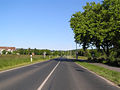
L 83 from Bechlinghoven in the direction of Holzlar Hauptstrasse


The watermill
The Holzlar watermill (position) on the Mühlenbach is a gem . According to the current state of knowledge, it is the only functioning historical mill in the Bonn area; the original mill pond no longer exists.
The Holzlarer Mühle is an early industrial cultural monument. Only a few reliable data are available on its history. Presumably a mill existed very early, in connection with a castle courtyard , which passed to the Landdrosten Wilhelm von Nesselrode in 1502 and was destroyed in the war times of the 16th century. In the middle of the 19th century, the Reuter family acquired the mill from Count von Nesselrode . The first mention of the Reuter family as tenants of the mill at the beginning of the 19th century is also historically certain. In the 1950s the mill was shut down by the last miller, Josef Reuter.
In 1989 the Holzlarer Mühle eV was founded. Thanks to generous support from the city of Bonn, various private and public institutions and numerous citizens of Holzlar, as well as a grant from the North Rhine-Westphalia Foundation , the association was able to restore the mill in 1994 after several years of work. The association organizes there for the German Milling Day , the Open Monument Day and, by appointment, guided tours and, together with the Holzlar Citizens Association, the Holzlar Christmas Market every year on the second Saturday in Advent in Mühlenweg, with the mill serving as a sales and exhibition space.

Holzlar watermill

Holzlar watermill


Christ the King Church

The Catholic Christ the King Church was built in 1953. The neighboring district of Hoholz and the chapel in Birlinghoven Castle also belong to the parish of Christ König .
Evangelical community center

The community center of the Evangelical Church Community Bonn-Holzlar was established in 1974/1975; the parish hall was ceremoniously opened on the 4th Sunday in Advent 1974 and in 2016 was named "Dornbuschkirche". The motif for the large window in the church area is the burning bush ( Ex 3.2 LUT ), designed by Prof. Karl Dedy senior, Bergisch Gladbach and Cologne. 18 years later, also on the 4th Sunday in Advent, the owl organ with 16 registers was inaugurated.
Old Protestant cemetery
Between the main street and the Hövelweg there is an approx. 330 square meter cemetery with around 50 graves. This cemetery is amonumentundermonument protectionbecause it is one of the oldest Protestant cemeteries throughout the Rhineland. It was laid out in the middle of the 17th century by the Linder family. Today it is owned by the Evangelical Church Community of Bonn-Holzlar.
The oldest gravestone in the cemetery, which is also called "Linder's Garden", bears the inscription "M. Linder ”and is from the year 1658. The Lindershausweg, which is located in the immediate vicinity of the cemetery, still reminds of the Linder family, who later called themselves Linden.
Contrary to the information on the board (it says 1860), the cemetery was expanded in 1816 by the mountain master Leopold Bleibtreu (* May 30, 1777; † September 11, 1839). Today there are a total of 14 tombstones bearing the name Bleibtreu .
The cemetery was closed in 1968; In 1983 it was included in the list of monuments of the city of Bonn. After the closure, some named people were buried in family graves until 2006 or 2007.

Old possible cemetery

Old possible cemetery

Gravestone of Leopold Bleibtreu


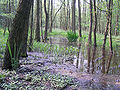
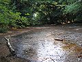
Landscape and rare animals
The landscape of Holzlar is characterized by the steep slope from which Heidebergen, Gielgen and Roleber sometimes see Cologne Cathedral, and in the south and east by forests, streams , lakes and ponds . In Holzlar there are the nature reserves Weiers Wiesen, wet grassland fallow and hay meadows Kohlkaul, wet meadows with quarry forest Kohlkaul and Wolfsbachtal as well as the landscape protection area Giersberg
In the west, Holzlar meets the Ennert ridge, which is mostly covered with mixed forest , including some stately oaks, and belongs to the Siebengebirge nature reserve , but not to the Siebengebirge nature park; it shields Holzlar from the Rhine valley.
The numerous hiking trails in the Ennert make it a popular local recreation area in the Bonn area. There are also some sources there, some of which are not mapped.
The mapped streams are called:
Rare animals such as fire salamanders, smooth snakes, great spotted woodpeckers and blindworms feel at home in the streams, lakes and ponds. In the northern and western parts of Holzlar, the landscape is free of forests and consists largely of fields with a landscape typical of the Cologne-Bonn Bay; However, like the neighboring Ennert, Holzlar is part of the Pleiser Hügelland natural area .
Idyll in the Ennert

Mühlenbach in Holzlar
“Roter Bach” in the Ennert
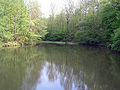
Holzlarer See


societies
Holzlar is characterized by a lively club life. Among other things, there has been a sports club with around 1,300 members (BSV Roleber 1919 eV), several carnival clubs - the Veedelszoch Holzlar festival committee provides the Holzlar child prince couple - and four very active civic associations.
economy
In 1935 Reinold Hagen founded the Kautex-Werke (first electroplating workshops ) for the processing of plastic, later in particular hollow molds (vehicle tanks) and machines for their production; The successors are Kautex Textron and Kautex Maschinenbau . The neighboring Dr. Reinold Hagen Foundation operates an inter-company training workshop.
Around 1994 the Rhineland Chamber of Agriculture erected a new building on the southern outskirts; In 2004 it was organizationally merged with the Westphalia Chamber of Agriculture to form the North Rhine-Westphalia Chamber of Agriculture (corporation under public law). In 2016, the location was closed and relocated to Münster and Cologne-Auweiler.
Personalities
- Abraham Bleibtreu (1775–1852), builder of the alum works in Holzlar
- Leopold Bleibtreu (1777–1839), operator of the alum works in Holzlar, brother of Abraham Bleibtreu
- Stephan Eisel (* 1955), German politician and former member of the Bundestag
- Peter Gabrian (1922–2015), artist, midsummer night painter in Finland
- Reinold Hagen (1913–1990), entrepreneur, founded the Holzlarer Kautex-Werke
- Hagen Hultzsch (* 1940), German manager, member of the Board of Management of Deutsche Telekom AG 1991–2001
- Ulrich Kelber (* 1968), German politician and member of the Bundestag
- Wolfgang Kubin (* 1945), German sinologist and professor at the University of Bonn
- Paul Langen (1893–1945), former rector of the Catholic elementary school in Holzlar, opponent and victim of National Socialism
- Helmut Stahl (* 1947), German politician and former member of the state parliament
- Marieluise Zizmann (* 1947), former German badminton player
See also
- List of architectural monuments in the Holzlar district of Bonn
- List of crossroads and wayside shrines in the Holzlar district of Bonn
Web links
Individual evidence
- ↑ Population in Bonn by districts (according to the main statute) on December 31 , 2018 , Federal City of Bonn - Statistics Office, February 2019
- ↑ http://www.bv-heidebergen.de/ortteile-heidebergen.html
- ^ Friedrich Falk: A forgotten Rhenish brown coal area. Lignite mining underground on the northern slope of the Siebengebirge. Rheinlandia Verlag, Siegburg 2002, ISBN 3-935005-51-2 , p. 51.
- ↑ Home page of the Research Center for Hunting and Game Damage Prevention
- ^ Friedrich Falk: A forgotten brown coal area. Lignite mining underground on the northern slope of the Siebengebirge. Rheinlandia Verlag, Siegburg 2002, ISBN 3-935005-51-2 , p. 65.
- ↑ Monument and History Association Bonn rrh .: History trail lignite + alum with display boards (accessed August 6, 2019)
- ↑ a b Community encyclopedia for the Kingdom of Prussia from 1885
- ↑ Martin Bünermann: The communities of the first reorganization program in North Rhine-Westphalia . Deutscher Gemeindeverlag, Cologne 1970, p. 82 .
- ↑ Hans Luhmer: From the mayor's office of Menden to the community of Sankt Augustin In: Contributions to the history of the city , published by the Sankt Augustin city archive. Issue 20, 1994, ISSN 0936-3483
- ↑ State Surveying Office North Rhine-Westphalia: Directory of the districts in NRW (file vg_gemarkungen.dbf; data license Germany attribution 2.0 , provider: State of NRW (2018))
- ↑ Winfried Lenders (ed.): The Holzlarer mill. Holzlarer Mühle eV, Bonn, 1999, ISBN 3-9806916-0-8 .
- ^ Resolution of the presbytery dated November 13, 2016
- ↑ a b To the website of the Evangelical Church Community Bonn-Holzlar
- ↑ See archive of the Evangelical Church Community Bonn-Holzlar
- ^ Rudolf Cramer: The Evangelical Cemetery in Holzlar. Studies on the local history of the Bonn-Beuel district 35, Bonn 2008, ISBN 978-3-922832-42-3 , p. 63
- ↑ Monuments in Beuel. Buried in farmer Linder's garden. Retrieved October 9, 2015.
-
↑ Rainer Schmidt: Bonn's smallest cemetery is hidden in Holzlar, Bonner General-Anzeiger of August 18, 2018, p. 28
Rainer Schmidt: Buried in Bauer Linder's garden , online article in the Bonner General-Anzeiger, 2015-10-08. - ↑ Identifiers BN-6, BN-8 (Wolfsbachtal) to BN-10, http://nsg.naturschutzinformationen.nrw.de/nsg/de/fachinfo/gebiete/kreise/koeln/2073
- ↑ Map with the landscape and nature reserves https://www.bonn.de/themen-entsehen/umwelt-natur/naturschutzgebiet-kohlkaul-1.php
- ↑ Homepage of the “Dr. Reinold Hagen Foundation "

City districts: Bad Godesberg | Bulge | Bonn | Hardtberg
Districts: Alt-Godesberg | Auerberg | Beuel center | Beuel-Ost | Bonn-Castell | Bonn Center | Brüser Berg | Buschdorf | Dottendorf | Dransdorf | Duisdorf | Endeich | Friesdorf | Geislar | Godesberg-North | Godesberg villa district | Graurheindorf | Gronau | Hard height | Heiderhof | Hochkreuz | Wood | Holtorf | Holzlar | Ippendorf | Kessenich | Küdinghoven | Lannesdorf | Lengsdorf | Lessenich / Meßdorf | Limperic | Flour | Muffendorf | Nordstadt | Oberkassel | Pennenfeld | Plittersdorf | Poppelsdorf | Pützchen / Bechlinghoven | Ramersdorf | Röttgen | Rüngsdorf | Schwarzrheindorf / Vilich-Rheindorf | Schweinheim | Südstadt | Fir bush | Ückesdorf | Venusberg | Vilich | Vilich-Müldorf | West town