
Gondola
| coat of arms | Germany map | |
|---|---|---|

|
Coordinates: 50 ° 14 ' N , 6 ° 25' E |
|
| Basic data | ||
| State : | Rhineland-Palatinate | |
| County : | Eifel district Bitburg-Prüm | |
| Association municipality : | Prüm | |
| Height : | 450 m above sea level NHN | |
| Area : | 23.05 km 2 | |
| Residents: | 472 (Dec. 31, 2019) | |
| Population density : | 20 inhabitants per km 2 | |
| Postal code : | 54595 | |
| Area code : | 06551 | |
| License plate : | BIT, PRÜ | |
| Community key : | 07 2 32 227 | |
| Community structure: | 6 districts | |
| Association administration address: | Tiergartenstrasse 54 54595 Prüm |
|
| Website : | ||
| Local Mayor : | Klaus Nägel | |
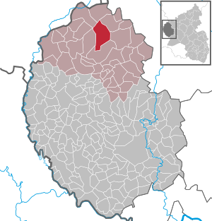
| Location of the local community Gondenbrett in the Eifelkreis Bitburg-Prüm | ||
  |
||

.jpg)
Gondenbrett is a municipality in the Eifelkreis Bitburg-Prüm in Rhineland-Palatinate . It belongs to the community of Prüm .
Geographical location
The place is in the Mehlental at the foot of the Schneifel . The districts of Niedermehlen , Obermehlen and Wascheid as well as part of the Walcherath settlement and the block house Schwarzer Mann belong to the community of Gondenbrett .
history
It was first mentioned in the Prümer Urbar from 893. At that time Gunnebreth and Wassersceit were about three to four kilometers from where they are today on the ridge of the Schneifel. In the Middle Ages , when the residents fled the plague , both places were rebuilt in the valley of the Mehlenbach.
Today's community was created on January 1, 1971 through a new formation from the three previously independent communities Gondenbrett (then 199 inhabitants), Mehlen bei Prüm (134) and Wascheid (175). Mehlen near Prüm was created on June 7, 1969 through the merger of the two communities Niedermehlen and Obermehlen.
- Statistics on population development
The development of the population of Gondenbrett in relation to today's municipality; the values from 1871 to 1987 are based on censuses:
|
|
Municipal council
The municipal council in Gondenbrett consists of eight council members, who were elected in the local elections on May 26, 2019 in a personalized proportional representation, and the honorary local mayor as chairman. The eight seats in the municipal council are divided between two groups of voters . Until 2009 the council had twelve council members.
Attractions
- Large parts of the Schneifelrücken , which is accessible by numerous hiking trails and in winter by a ski slope and several cross-country trails, and its highest elevation, the Black Man, are located in the area of the municipality
- The reservoir near Wascheid
- The juniper area between Niedermehlen and Steinmehlen
Web links
- Local community Gondenbrett on the pages of the Association of Prüm
- To search for cultural goods of the local community Gondenbrett in the database of cultural goods in the Trier region .
Individual evidence
- ↑ State Statistical Office of Rhineland-Palatinate - population status 2019, districts, communities, association communities ( help on this ).
- ↑ Official municipality directory (= State Statistical Office of Rhineland-Palatinate [Hrsg.]: Statistical volumes . Volume 407 ). Bad Ems February 2016, p. 164 (PDF; 2.8 MB; see also footnote 19, p. 184).
- ↑ State Statistical Office Rhineland-Palatinate - regional data
- ^ The Regional Returning Officer Rhineland-Palatinate: Local elections 2019, city and municipal council elections

Auw at Prüm | Lead alf | Brandscheid | Buchet | Büdesheim | Dingdorf | Fire divider | Fleringen | Giesdorf | Gondeboard | Großlangenfeld | Habscheid | Heckhuscheid | Heisdorf | Hersdorf | Kleinlangenfeld | Lasel | Masthorn | Matzerath | Mützenich | Neuendorf | Niederlauch | Nimshuscheid | Nimsreuland | Upper flap oath | Upper garlic | Olzheim | Orlenbach | Pittenbach | Pronsfeld | Prüm | Rommersheim | Roth near Prüm | Schönecken | Schwirzheim | Seiwerath | Celery | Wallersheim | Watzerath | Wawern | Weinsheim | Winringen | Winterscheid | Winterspelt