
Orlenbach
| coat of arms | Germany map | |
|---|---|---|

|
Coordinates: 50 ° 9 ' N , 6 ° 23' E |
|
| Basic data | ||
| State : | Rhineland-Palatinate | |
| County : | Eifel district Bitburg-Prüm | |
| Association municipality : | Prüm | |
| Height : | 450 m above sea level NHN | |
| Area : | 6.21 km 2 | |
| Residents: | 231 (Dec. 31, 2019) | |
| Population density : | 37 inhabitants per km 2 | |
| Postal code : | 54595 | |
| Area code : | 06556 | |
| License plate : | BIT, PRÜ | |
| Community key : | 07 2 32 290 | |
| Community structure: | 2 districts | |
| Association administration address: | Tiergartenstrasse 54 54595 Prüm |
|
| Website : | ||
| Local Mayor : | Matthias Maas | |
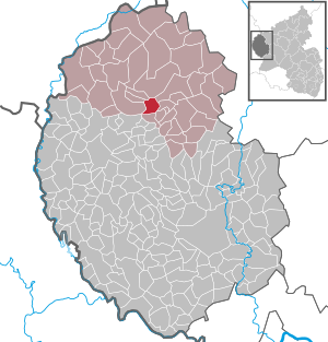
| Location of the local community Orlenbach in the Eifelkreis Bitburg-Prüm | ||
  |
||

_04.jpg)
Orlenbach is a municipality in the Eifelkreis Bitburg-Prüm in Rhineland-Palatinate . It belongs to the community of Prüm .
Geographical location
The two districts of Orlenbach and Schloßheck are located on the southern edge of the Prüm Kalkmulde and south of Prüm on the A 60 . The highest point is a forest ridge north of the Orlenbach district at 551 m above sea level. NHN .
history
Archaeological finds
Cremation graves found in the “Debertshecke” forest north of Orlenbach and examined by the Rheinisches Landesmuseum Trier in 1930 indicate the first settlement in the late Latène period (5th to 1st century BC). In 1990 remains of Roman ceramics were found in the parcel of Steinchen , which suggest a small Roman settlement.
Certificates
Schloßheck, the larger district of Orlenbach, is mentioned for the first time in a document from 1516. Orlenbach, which gives it its name, is documented between 1544 and 1621 in the description of the Oberlauch ban .
Territorial Affiliation
By the end of the 18th century Orlenbach belonged to the Community Luxembourg dairy farm or to kurtrierischen Hof Pronsfeld .
In connection with the First Coalition War , the region came under French administration in 1794 and from 1798 belonged to the canton of Arzfeld in the forest department .
After substantial parts of the Rhineland came to the Kingdom of Prussia in 1815 due to the treaties concluded at the Congress of Vienna , Orlenbach belonged to the mayor's office of Pronsfeld in the 1816 newly created district of Prüm .
Population development
The development of the population of Orlenbach, the values from 1871 to 1987 are based on censuses:
|
|
politics
Municipal council
The council in Orlenbach consists of six council members, who in the local elections on May 26, 2019 in a majority vote were elected, and the honorary mayor as chairman.
coat of arms
The coat of arms was designed by the heraldist Christian Credner from Lambertsberg.
Attractions
Cultural monuments
The Walburgis Church was built in 1743 and rebuilt in 1960 after war damage, a columned altar from the period of construction shows St. Peregrinus .
See also: List of cultural monuments in Orlenbach
Natural monuments
- At the southern exit of the village in the direction of Matzerath there is an old oak that has been designated a natural monument .
Web links
- Ortgemeinde Orlenbach on the website of the Association of Prüm
- To search for cultural assets of the local community Orlenbach in the database of cultural assets in the Trier region .
- Brief portrait of Orlenbach bei Hierzuland , SWR television
Individual evidence
- ↑ State Statistical Office of Rhineland-Palatinate - population status 2019, districts, communities, association communities ( help on this ).
- ↑ Dirk L. Krausse: Iron Age cultural change and Romanization in the Mosel-Eifel area . Catalog of references ( memento of March 8, 2014 in the Internet Archive ). Roman-Germanic Commission of the German Archaeological Institute. Frankfurt am Main. 2006, page 109 (PDF; 1.2 MB)
- ^ Johann Friedrich Schannat : Eiflia illustrata or geographical and historical description of the Eifel , Volume 4, 1854, page 317 ( Google Books )
- ^ Friedrich von Restorff : Topographical-statistical description of the Royal Prussian Rhine Province , Nicolai, Berlin and Stettin 1830, p. 881.
- ↑ State Statistical Office Rhineland-Palatinate - regional data
- ^ The Regional Returning Officer Rhineland-Palatinate: Local elections 2019, city and municipal council elections

Auw at Prüm | Lead alf | Brandscheid | Buchet | Büdesheim | Dingdorf | Fire divider | Fleringen | Giesdorf | Gondeboard | Großlangenfeld | Habscheid | Heckhuscheid | Heisdorf | Hersdorf | Kleinlangenfeld | Lasel | Masthorn | Matzerath | Mützenich | Neuendorf | Niederlauch | Nimshuscheid | Nimsreuland | Upper flap oath | Upper garlic | Olzheim | Orlenbach | Pittenbach | Pronsfeld | Prüm | Rommersheim | Roth near Prüm | Schönecken | Schwirzheim | Seiwerath | Celery | Wallersheim | Watzerath | Wawern | Weinsheim | Winringen | Winterscheid | Winterspelt