
Dingdorf
| coat of arms | Germany map | |
|---|---|---|

|
Coordinates: 50 ° 9 ′ N , 6 ° 26 ′ E |
|
| Basic data | ||
| State : | Rhineland-Palatinate | |
| County : | Eifel district Bitburg-Prüm | |
| Association municipality : | Prüm | |
| Height : | 403 m above sea level NHN | |
| Area : | 3.81 km 2 | |
| Residents: | 109 (Dec. 31, 2019) | |
| Population density : | 29 inhabitants per km 2 | |
| Postal code : | 54614 | |
| Area code : | 06553 | |
| License plate : | BIT, PRÜ | |
| Community key : | 07 2 32 216 | |
| Association administration address: | Tiergartenstrasse 54 54595 Prüm |
|
| Website : | ||
| Local Mayor : | Albert Thielen | |
| Location of the local community Dingdorf in the Eifelkreis Bitburg-Prüm | ||
  |
||


Dingdorf is a municipality in the Eifelkreis Bitburg-Prüm in Rhineland-Palatinate . It belongs to the community of Prüm .
geography
Dingdorf is located in a wide valley in the southwest part of the Prümer Kalkmulde . Prüm is about seven kilometers north.
Neighboring communities are Oberlauch , Schönecken , Nimsreuland , Heisdorf , Matzerath , Winringen and Niederlauch .
history
The Prüm Abbey had possessions in Dingdorf as early as the 8th century. In the Prümer Urbar the place was called 893 "Dydendorpth" and "Diedendorpth". Later the place belonged to the rule Schönecken and from the 14th to the end of the 18th century to the Electorate of Trier . Dingdorf was the main town of one of the four Maiereien into which the Electoral Trier office of Schönecken was divided. The places Dingdorf, Giesdorf , Heisdorf , Niederlauch , Winringen and the Mühle zu Schweißthal belonged to this dairy . In 1684, Dingdorf had four fireplaces .
After 1792 French revolutionary troops occupied the left bank of the Rhine . Under the French administration, Dingdorf was assigned to the canton of Prüm from 1798 to 1814 , which belonged to the arrondissement of Prüm in the Saardepartement . Dingdorf was the chief town ( chef-lieu ) of a Mairie .
After the Congress of Vienna , Dingdorf came to the Kingdom of Prussia in 1815 . Under the Prussian administration, Dingdorf belonged to the newly formed district of Prüm in the Trier administrative district in 1816 and became the seat of the mayor's office of the same name .
- Population development
The development of the population of Dingdorf, the values from 1871 to 1987 are based on censuses:
|
|
Municipal council
The council in Dingdorf consists of six council members, who in the local elections on May 26, 2019 in a majority vote were elected, and the honorary mayor as chairman.
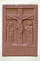
Attractions
- Chapel from 1868 with stone sculptures, including a crucifixion group from around 1600.

Chapel of St. Joseph
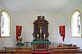
inner space

Crucifixion relief
Crucifixion group
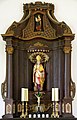
baroque altarpiece

Mary with child
_03.jpg)
_08.jpg)
_06.jpg)
_07.jpg)
_10.jpg)
_14.jpg)
Web links
- Local community Dingdorf on the website of the Association of Prüm
- To search for cultural assets of the local community Dingdorf in the database of cultural assets in the Trier region .
Individual evidence
- ↑ a b State Statistical Office of Rhineland-Palatinate - population status 2019, districts, municipalities, association communities ( help on this ).
- ^ A b Philipp de Lorenzi: Contributions to the history of all parishes in the Diocese of Trier . Episcopal General Vicariate, Trier 1887, p. 495 ( dilibri.de )
- ^ Heinrich Beyer : Mittelrheinisches Urkundenbuch, Volume I, Coblenz: Hölscher, 1860, p. 147 dilibri.de
- ^ Johann Friedrich Schannat , Georg Bärsch : Eiflia illustrata or geographical and historical description of the Eifel , Volume 3, Edition 2, Part 1, Mayer, 1854, p. 240 ( Google Books )
- ^ Wilhelm Fabricius : Explanations for the historical atlas of the Rhine province, Volume 2: The map of 1789. Bonn 1898, p. 152.
- ↑ State Statistical Office Rhineland-Palatinate - regional data
- ^ The Regional Returning Officer Rhineland-Palatinate: Local elections 2019, city and municipal council elections

Auw at Prüm | Lead alf | Brandscheid | Buchet | Büdesheim | Dingdorf | Fire divider | Fleringen | Giesdorf | Gondeboard | Großlangenfeld | Habscheid | Heckhuscheid | Heisdorf | Hersdorf | Kleinlangenfeld | Lasel | Masthorn | Matzerath | Mützenich | Neuendorf | Niederlauch | Nimshuscheid | Nimsreuland | Upper flap oath | Upper garlic | Olzheim | Orlenbach | Pittenbach | Pronsfeld | Prüm | Rommersheim | Roth near Prüm | Schönecken | Schwirzheim | Seiwerath | Celery | Wallersheim | Watzerath | Wawern | Weinsheim | Winringen | Winterscheid | Winterspelt