Gormaz (Soria)
| Gormaz municipality | ||
|---|---|---|
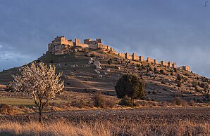
 Gormaz - castle (castillo)
|
||
| coat of arms | Map of Spain | |
 Help on coat of arms |
|
|
| Basic data | ||
| Autonomous Community : |
|
|
| Province : | Soria | |
| Comarca : | Comarca de Soria | |
| Coordinates | 41 ° 30 ′ N , 3 ° 0 ′ W | |
| Height : | 960 msnm | |
| Area : | 15.72 km² | |
| Residents : | 16 (Jan. 1, 2019) | |
| Population density : | 1.02 inhabitants / km² | |
| Postal code : | 42313 | |
| Municipality number ( INE ): | 42097 | |
| administration | ||
| Website : | Gormaz | |
Gormaz is a place and a small municipality ( municipio ) with only 16 inhabitants (as of January 1, 2019) in the northern Spanish province of Soria in the autonomous community of Castile and León .
location
The place Gormaz is located on the north bank of the Duero almost 65 km (driving distance) southwest of Soria at an altitude of about 960 m above sea level. d. M. The small town of El Burgo de Osma is only about 15 km to the northwest. The climate in winter is cool, but in summer it is quite warm; the low rainfall (approx. 485 mm / year) falls - with the exception of the rather poor summer months - distributed over the whole year.
Population development
| year | 1900 | 1950 | 2000 | 2016 |
| Residents | 198 | 182 | 17th | 26th |
The significant population decline since the 1950s is mainly due to the mechanization of agriculture and the associated loss of jobs.
economy
In the Middle Ages soldiers, small traders, craftsmen and service providers of all kinds settled in the almost exclusively agricultural rural community.
history
Small Bronze Age , Celtic and Roman finds were made in the municipality . The bridge over the Duero, which was later repeatedly renewed, probably also dates from Roman times. In the 8th century, the Moors penetrated into the region and built a small fortress (hisn) , which in the second half of the 10th century was expanded to become the largest fortress in the western world at that time, because the Duero was the always contested border between the Christian Roman and Islamic sphere of influence. Under the leadership of the Castilian Count García Fernández († 995) the fortress was unsuccessfully besieged in 974; it remained controversial well into the 11th century and was not conquered for the Christians until 1059 under Ferdinand I (r. 1035-1065) ( reconquista ) ; Rodrigo Díaz de Vivar († 1099), better known under the name El Cid , was at times lord of the castle and landlord (señor) of the place. After the Moors were pushed back further in the 12th and 13th centuries, the castle and town lost their strategic importance.
Attractions
- The biggest attraction of the place is its huge fortress, largely dating from the Moorish era, with its numerous angular flank towers. Unlike most Moorish fortresses, which are usually mixed in with small stones rammed exist, it is built of precisely hewn dressed stone. The entire wall ring is approx. 1200 m long and up to 10 m high; the portal shows horseshoe arches framed by an alfiz . Inside is a separated by a thick defensive wall with towers palace area were (alcázar) , which in Mudéjarstil erbauter keep (Torre del homenaje) comes from the Christian era, and probably of wood and mud-built stables and other premises (kitchen, forging etc.) , of which, however, nothing has been preserved; there are only remains of cisterns (aljibes) .
- The Ermita de San Miguel dates from around 1100 and is located on the terraced and formerly cultivated flanks of the castle hill. A porch ( portico ) was added on the south side ; the small bell gable (espadaña) was also added later. While the apse is barrel vaulted , the nave is only spanned by an open roof structure .
- The medieval Iglesia de Santiago is dedicated to the Apostle James the Elder. Ä. consecrated to the spiritual leader of the Reconquista; however, it is in ruins and houses the local cemetery.
- The Iglesia de San Juan Bautista , built in the 17th century, is the parish church of the village.
Video
- Terra X Expeditions into the Unknown - The Treasure of the Knights Templar, Gottfried Kirchner, 1995
Web links
Individual evidence
- ↑ Cifras oficiales de población resultantes de la revisión del Padrón municipal a 1 de enero . Population statistics from the Instituto Nacional de Estadística (population update).
- ↑ Gormaz - map with altitude information
- ↑ Gormaz - climate tables
- ^ Gormaz - population development
- ↑ Gormaz - Castillo (Arteguias)
- ↑ Gormaz - Castillo ( Memento of the original from October 28, 2017 in the Internet Archive ) Info: The archive link was inserted automatically and has not yet been checked. Please check the original and archive link according to the instructions and then remove this notice.
- ^ Gormaz - Castillo

