
Burglauer
| coat of arms | Germany map | |
|---|---|---|

|
Coordinates: 50 ° 17 ' N , 10 ° 11' E |
|
| Basic data | ||
| State : | Bavaria | |
| Administrative region : | Lower Franconia | |
| County : | Rhön-Grabfeld | |
| Management Community : | Bad Neustadt an der Saale | |
| Height : | 231 m above sea level NHN | |
| Area : | 13.95 km 2 | |
| Residents: | 1712 (Dec. 31, 2019) | |
| Population density : | 123 inhabitants per km 2 | |
| Postal code : | 97724 | |
| Area code : | 09733 | |
| License plate : | NES, CAN, MET | |
| Community key : | 09 6 73 186 | |
| LOCODE : | DE QAU | |
| Community structure: | 2 districts | |
| Address of the municipal administration: |
Kirchstrasse 1 97724 Burglauer |
|
| Website : | ||
| First Mayor : | Marco Heinickel ( CSU ) | |
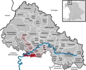
| Location of the municipality of Burglauer in the Rhön-Grabfeld district | ||
  |
||


Burglauer is a municipality in the Lower Franconian district of Rhön-Grabfeld and a member of the Bad Neustadt an der Saale administrative community .
geography
The community is located in the Main-Rhön region on the Lauer River .
Community structure
There are two parts of the community:
- Burglauer
- Höhbergsmühle
There are the districts of Burglauer, Burglauer Wald and Steinacher Forst l. d. Saale.
history
Until the church is planted
Burglauer was first mentioned in a document from Emperor Arnulf of Carinthia on March 11, 899. From the end of the 11th century, Lure Castle (Burg Lauer) is mentioned in the village, which was renovated in 1225 and pillaged in the peasant uprising in 1525. In the centuries that followed, the castle fell into disrepair, so that only ramparts and the castle cellar are preserved today. In the course of time, various sexes had their residences there, such as von Lure, von Steinau called Steinrück , von Ostheim, von der Spleen and von der Kehre. Another castle complex was probably located on the "small Höhberg" in today's municipality during the time of the migrations . Also in this area, the ruins of Steineck Castle are worth mentioning, which the Thirty Years War rolled down. The office of the Hochstift Würzburg was secularized in 1803 in favor of Bavaria and fell to Archduke Ferdinand of Tuscany in the Peace of Pressburg (1805) to form the Grand Duchy of Würzburg . The rights of the Barons von Gebsattel (Rittergut Lebenhan), mediated in 1806, fell to Bavaria in 1814 . In the course of the administrative reforms in Bavaria, today's municipality was created with the municipal edict of 1818 .
District affiliation
The community belonged to the Bad Kissingen district until April 30, 1978 .
Population development
- 1961: 1096 inhabitants
- 1970: 1163 inhabitants
- 1987: 1372 inhabitants
- 1991: 1466 inhabitants
- 1995: 1609 inhabitants
- 2000: 1685 inhabitants
- 2003: 1676 inhabitants
- 2005: 1682 inhabitants
- 2007: 1677 inhabitants
- 2008: 1685 inhabitants
- 2009: 1659 inhabitants
- 2010: 1631 inhabitants
- 2011: 1640 inhabitants
- 2012: 1633 inhabitants
- 2013: 1656 inhabitants
- 2014: 1667 inhabitants
- 2015: 1649 inhabitants
politics
coat of arms
|
|
Blazon : “In silver, a narrow blue wavy bar; above three, two-to-one, six-spoke black wheels, below a red pinnacle tower with an open gate. " |
Architectural monuments
Soil monuments
Economy and Infrastructure
Economy including agriculture and forestry
According to official statistics, there were 100 employees in the manufacturing sector in 1998 and no employees at the place of work in the trade and transport sector. There were a total of 592 employees at the place of residence subject to social security contributions. There was one company in the manufacturing sector and two companies in the construction sector. In addition, there were 19 farms in 1999 with an agricultural area of 549 hectares, of which 504 hectares were arable land.
education
The following institutions exist (as of 2018):
- A day care center with 80 places and 71 children
- an elementary school with four classes and 87 students
sons and daughters of the town
- David Mottl , (1977 *) Cooking with a star in the Michelin guide awarded
Web links
Individual evidence
- ↑ "Data 2" sheet, Statistical Report A1200C 202041 Population of the municipalities, districts and administrative districts 1st quarter 2020 (population based on the 2011 census) ( help ).
- ↑ Mayor. Burglauer municipality, accessed on July 21, 2020 .
- ↑ a b c Federal Statistical Office (ed.): Historical municipality directory for the Federal Republic of Germany. Name, border and key number changes in municipalities, counties and administrative districts from May 27, 1970 to December 31, 1982 . W. Kohlhammer GmbH, Stuttgart / Mainz 1983, ISBN 3-17-003263-1 , p. 739 .
- ^ Entry on Burglauer's coat of arms in the database of the House of Bavarian History

Aubstadt | Bad Königshofen im Grabfeld | Bad Neustadt an der Saale | Bastheim | Bischofsheim in the Rhön | Burglauer | Fladungen | Großbardorf | Großeibstadt | Hausen | Hendungen | Herbstadt | Haystack | Höchheim | Hohenroth | Hollstadt | Mellrichstadt | Niederlauer | Nordheim before the Rhön | Oberelsbach | Top litter | Ostheim before the Rhön | Rödelmaier | Hall on the Saale | Salt | Sandberg | Schönau an der Brend | Sondheim before the Rhön | Stockheim | Radiations | Sulzdorf an der Lederhecke | Sulzfeld | Trappstadt | Unsleben | Willmars | Wollbach | Wülfershausen on the Saale
Unregulated areas in the district of Rhön-Grabfeld Bundorfer Forst |
Burgwallbach Forest |
Forest Schmalwasser-Nord |
Forest Schmalwasser-Süd |
Mellrichstadter Forest |
Steinacher Forest on the right of the Saale |
Sulzfelder Forest |
Weigler