
Iller cycle path

The Iller bike path , the official signs along the way almost continuously Iller bike trail called, leads to a distance of about 146 km from Oberstdorf to Ulm . The path follows the course of the Iller . The starting point is the origin of the Iller . There the confluence of Breitach , Stillach and Trettach forms the mountain river Iller in the Allgäu . More or less directly along the river it goes down to the Danube to Ulm, where the Iller flows into the Danube.
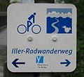
The Iller cycle path is usually marked with the abbreviations IR or IRW on the cycle path maps .
The cycle path runs along the Danube-Iller-Rhein-Limes from Aitrach to Ulm . The Main-Danube-Bodensee-Weg , HW 4 of the Swabian Alb Association , largely coincides with the Iller Cycle Route between Senden and Ulm. From the origin of the Iller onwards, the first kilometers of the Iller cycle path are identical to the European long-distance hiking trail E5 .
Locations and stations along the route
Image gallery

At the source of the Iller , where the sculpture of the same name by Walter Kalot is right next to the bike path

Upper Illertal to the north at around river kilometer 15. Top left is the Schöllang castle church , right on the embankment the Iller cycle path

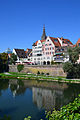
The historic city of Kempten is also crossed on the Iller cycle path.
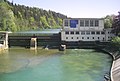
Power plants with barrages appear regularly on the Iller cycle path, here near Aitrach
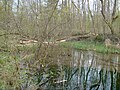
The quiet Iller floodplain forest near Illertissen is a natural experience. The Iller cycle path gives good insights into this biotope. Teaching boards show the special features.

The end of the Iller cycle path. The Iller (top left) flows into the Danube above Neu-Ulm (right in the foreground).
End point or starting point of the Iller Cycle Path: the twin cities of Ulm / Neu-Ulm


Route


Main way
The bike path usually leads directly along the river. You have to accept a smaller smear between Dietmannsried and Illerbeuren, where you are directed away from the river. However, the route at this point leads on country roads with very little traffic. The route directly on the Iller is level, with smaller inclines and descents, especially on the secondary routes.
The cycle path is family-friendly because it is easy to navigate with children aged eight and over. The dense network of stations along the Illertalbahn between Ulm and Oberstdorf enables individual stages as a day trip.
The bike path is not asphalted for long stretches, the route is virtually free of traffic. Agricultural or forestry utility vehicles or the vehicles of the water management authority appear only occasionally. The path is signposted throughout - in both directions. There are good arguments for one and the other direction of travel:
- A trip in the direction of the river to the north speaks that there is a gradient almost all of the way, so that many passages are slightly downhill.
- On the other hand, the fact that the broader chain of the Allgäu Alps is more visible the further south you go the more south you come to speak in favor of driving against the direction of the river .
signpost
Route sign : the Ulmer Spatz at the bottom right , then the Allgäu Alpine panorama in the far horizon, from which the Iller flows in arches. On the left a stylized cyclist.

These yellow signs on the banks of the Iller also offer cyclists the best possible orientation. From the mouth of the Iller, they stand consistently at a distance of 200 meters on the bank and end in Oberstdorf .

This sign, which marks the European long-distance hiking trail E5, appears on the Iller cycle path, because in the area of the Upper Illertal the E5 runs on the same route.

One of the many branches off the Iller cycle path: the Bodensee-Königssee cycle path, for example, continues in a westerly and easterly direction

At the mouth of the Iller, the Iller cycle path runs on HW 4 of the Swabian Alb Association.

The Danube Cycle Path is the natural continuation of the Iller Cycle Path in Ulm. In Oberstdorf you can cross the Alps on two mountain bike routes following the Iller cycle path.


.PNG)

Characteristic
Most of the time, the gravel path runs along the Illerdamm, at least for long stretches alongside the river. There are only inclines before Kempten, behind Krugzell, near Altusried, in Bad Grönenbach, in Sommersberg and near Ferthofen. The river side is changed again and again, some passages also run optionally to the right or left. In the lower part of the cycle path, the Iller forms the border between the federal states of Baden-Württemberg and Bavaria.
A charging station has been set up for e-bikes in the Brautgasse am Münster in Ulm .
In 2016, the path was re-signposted and prepared for 135,000 euros. The paths on the Iller have been graveled again in many places.
Landscape image and backgrounds
Detour
Some detours extend the entire route, but interrupt the path in nature in favor of culture:
- Some cyclists go around the Niedersonthofener See ; the bike path runs on the left side of the river near Martinszell anyway
- a visit to the castle of Bad Grönenbach is possible if you stay to the right of the Iller
- a visit to the pilgrimage churches of Maria Schnee in Legau and Maria Steinbach is recommended if you decide to go to the left side of the river in Krugzell
- a detour to the former Free Imperial City of Memmingen is well signposted as a cycle path (6 km)
- a short detour to the Buxheim Charterhouse and the Carthusian Lake south of Buxheim is worthwhile
Alternative route
Some types of bicycles, such as racing bikes or handbikes, cannot cope fully with the graveled causeway right next to the river. In the event of heavy rainfall and regularly recurring high water levels in the Iller, countless puddles and flood passages can be expected on the designated Iller cycle path. Natural disasters such as the Whitsun floods in 1999 , the Alpine floods in 2005 and the floods in Central Europe in 2013 do not repeat themselves to this extent annually along the Iller, but smaller variants of them do, mostly in connection with the spring snowmelt. The sections are then temporarily blocked by the floodplain landscape that accompanies the river. This is another reason why it can be important to switch to the asphalted variants, which is possible practically everywhere.
Connectivity
There are numerous connection and branching options to the other southern German cycle network and long-distance cycle paths on the Iller cycle path :
- Danube bike path , bike path Danube Lake Constance , Alb-Neckar cycle path and Hohenlohe-Ostalb-way near Ulm / Neu-Ulm
- Kneipp cycle path near Bad Grönenbach
- Allgäu cycle path near Kempten
- Lake Constance-Koenigssee cycle path near Immenstadt
- Heckmair route (mountain bike route) and Joe route near Oberstdorf - but only for mountain bikes and the like. Ä.
Literature and maps
Books
- Iller cycle path from Oberstdorf to Ulm , 1: 50,000, bikeline-Radtourenbuch, Verlag Esterbauer , 2nd (revised) edition 2008, ISBN 978-3-85000-126-7
cards
In the following maps, the Iller cycle path is explicitly drawn as such and highlighted in color, mostly with the abbreviations IR or IRW ; parallel routes and alternative routes are also recognizable.
General overview maps
- Leporello cycle route map Iller cycle path - with excursion destinations, refreshment and leisure tips , sheet 309, scale 1: 50,000, publisher Publicpress , Geseke, ISBN 978-3-8992-0309-7
- Cycle touring map, scale 1: 100,000, sheet 54 Upper Swabia , basic network of cycle paths and additional cycle paths, Baden-Württemberg State Surveying Office , Stuttgart 2002, ISBN 3-89021-554-8
- Bavaria network for cyclists , cycle network map on a scale of 1: 625,000 based on the overview map of Bavaria 1: 500,000, ed. from the Bavarian State Ministry of the Interior, Ministry of Economics, Infrastructure, Transport and Technology , Munich 2005, ISBN 3-910088-95-3
Maps with information about road surfaces and traffic density
- ADFC regional map, Allgäu cycling map , scale 1: 75,000, Memmingen, Kaufbeuren, Kempten, Bregenz, Bielefelder Verlag , Bielefeld, ISBN 978-3-87073-246-2
- ADFC regional map, cycling map of Ulm and the surrounding area , scale 1: 75,000, Ulm, Bielefelder Verlag (BVA), Bielefeld, ISBN 978-3-87073-245-5
Individual evidence
- ↑ The Iller cycle path. From Oberstdorf to Ulm. Bike tour book and map. Esterbauer-Verlag 2002, 1st edition, p. 8
- ↑ The Iller cycle path. From Oberstdorf to Ulm. Bike tour book and map. Esterbauer-Verlag 2002, 1st edition, p. 6
- ↑ A bit of a bumpy experience. Completely renewed and continuous Iller cycle path officially opened , article by Franz Glogger in the Südwest Presse Ulm on May 6, 2016, page 25
Web links
Coordinates: 47 ° 24 ′ 40 ″ N , 10 ° 16 ′ 38.9 ″ E