
Almopia
|
Almopia municipality Δήμος Αλμωπίας |
|||
|---|---|---|---|
|
|||
| Basic data | |||
| State : |
|
||
| Region : | Central Macedonia | ||
| Regional District : | Pella | ||
| Geographic coordinates : | 40 ° 59 ′ N , 22 ° 6 ′ E | ||
| Area : | 980.86 km² | ||
| Residents : | 27,556 (2011) | ||
| Population density : | 28.1 inhabitants / km² | ||
| Seat: | Aridea | ||
| LAU-1 code no .: | 1002 | ||
| Districts : | 2 parishes | ||
| Local self-government : |
1 city district 29 local communities |
||
| Website: | www.dimosalmopias.gov.gr | ||
| Location in the Central Macedonia region | |||
 |
|||

Almopia ( Greek Αλμωπία ( f. Sg. ), Slavic Meglen, Ottoman Karacaova ) is a historic landscape in Greece on the border with North Macedonia , was part of the Pella prefecture until the municipal reform in 1997 as the province of Almopia (Greek Eparchia Almopias ) and has been part of the Pella prefecture since 2011 a municipality in the northwest of the Central Macedonia region . Almopia was affected by a fundamental change in population between 1910 and 1930 as a result of the Balkan Wars and the Greco-Turkish War ; the current inhabitants are mostly Greeks descendants of refugees (especially Pontians , Cappadocians, Caucasians, Thracians and Turkish-speaking Asians Minor) from the area of present-day Turkey and Slavs and Slavic-speaking Greek Macedonians who have lived here since the Middle Ages , while all non-Greek Orthodox residents move to the province Bulgaria and Turkey had to leave. To this day, the northeast of Almopia is also part of the main settlement area of the Megleno -Romanians , a Balkan-Roman minority in Greece.
The thirty municipalities in the province of Almopia to date were combined in 1997 to form the two municipalities of Aridea and Exaplatanos . With the administrative reform of 2010 , the municipality Almopia was formed from these two municipalities, which has since had its administrative seat in the small town of Aridea.
Toponyms and Etymology
Almopia ( ancient Greek Ἀλμωπία Almōpia ) is the ancient Greek name for a district of ancient Macedonia , the inhabitants of which were referred to as Almōpes ( Ἀλμῶπες ) and whose name was traced back to a mythical giant Almops , son of Poseidon and the Helle, who was said to have been lived in this area., Ptolemy mentions three cities in this area, namely Horma ( Ὅρμα ), Eurōpos ( Εὔρωπος ) and Apsalos ( Ἄψαλος ). The current area of the municipality, which in the Middle Ages was given the Slavic name Meglen ('Nebel' maz. Меглен, Bulgarian Мъглен , Greek Μογλενά Moglena ), is located as the ancient Almopia. In early Byzantine times the area was presumably given the Greek name Enotia ( Ἐνωτία ) after a fortification of the same name near Notias , which was also used for the province from 1915 to 1927. The Turkish name of the area was Karacaova ('Black Valley ', Greek Καρατζόβα Karatzova ).
geography
Almopia has a number of topographical, geological, traffic-related and climatic features that clearly distinguish it from its surroundings.
Geographical location and topography

Almopia is located in the north-west of the Greek region of Central Macedonia and covers the Aridea plain, which is about 100-200 m above sea level, as well as the slopes of the surrounding mountains that almost completely enclose the municipality. The Voras Mountains demarcate the community from Edessa, bordering to the south, and from the west Macedonian Florina to the west; in the west and north it forms the state border with North Macedonia . The westernmost and highest point of the area is the main summit of the same name of the Voras ( 2524 m , also Kaimaktsalan ), the third highest peak in Greece, which marks a 'triangle' between western and central Macedonia and the Republic of North Macedonia. In the north, the Voras comes to an end with the Pinovo massif ( 2156 m ), which lies largely on the municipal territory. A little further to the northeast follows the Tzena or Kožuf massif, which with the Tzena ( 2182 m ) has another two-thousand- meter peak in the municipality. To the east, the Paiko massif rises between the Skra ( 1097 m ) north and the Meterizi ( 1598 m ), which forms the southern end. It marks the border with the municipality of Peonia to the east and separates Almopia from the area of the municipality of Pella in the southeast .
In the south, hill country similar to a low mountain range connects the southern foothills of the Voras and Paiko, here the municipality of Skydra borders on Almopia. The Aridea plain is drained by the Moglenitsas or Almopeos (Slavic Belica ) river. Its breakthrough into the Central Macedonian Plain marks the southernmost and deepest point of the municipality on the border with Skydra at almost 50 m above sea level. A road connection leads four kilometers further west over the Apsalos pass at a height of 145 m to the south into the plain. The Moglenitsas used to flow into Lake Giannitsa and left it as Loudias , hence the name Ano Loudias ('Upper Loudias'). The draining of the lake has made it a tributary of the Aliakmonas .
Numerous mountain streams form the source rivers of the Moglenitsas and irrigate the cultivated land of the plain. From the north the Koziakas ( Κόζιακας ), which rises at the summit of the same name, pours into the plain, from the northeast from the saddle between Tzena and Skra comes the Golemas ( Γκολέμας ), which around Notia is a small plain separated from the basin of Arideas (Greek Οροπέδιο ωνς άνς άνς άνς ω Αλμωπίας 'plateau of Upper Almopia') flows through, which like that is agriculturally cultivated. Coming from the Pinovo massif, the Xiropotamos flows into the Golemas.
To the west of the Moglenitsas flows the Toplitsa ( Τόπλιτσα ) or the Thermopotamos. This river rises as Rema Nikolaou on the Kresna in the Voras massif, flows through a narrow gorge and takes in the water from thermal springs at Loutra Loutrakiou , which are used for medicinal purposes with their metal-rich water and the toponymy of the area (Slavic Toplica and Greek Thermopotamos means' warm river ', Loutra ' baths'). South of the Toplitsa comes from the southern flank of the Kaimaktsalan the Aspropotamos, which flows into the Moglenitsas at Ydrea.
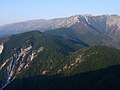
The main ridge of the Voras forms the border with the Republic of Macedonia 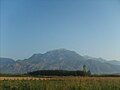
The Pinovo above the plain of Aridea 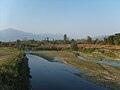
The Moglenitsas at Chrysi in summer 
The basin of Ano Almopia with the village of Notia


climate

Almopia has a warm, temperate continental climate with relatively dry, warm summers and cool, rainy winters. At the weather station in Aridea, an average of 5.3 days of snowfall was recorded from November to March from 1983 to 1992, while a snow cover of over 50 cm is not uncommon on the Voras from an altitude of over 1000 meters. Fog appeared on the plains on an average of 181 days per year , in spring and autumn it tended to be somewhat more frequent than in the other seasons. Upper Almopia is significantly cooler than the Aridea plain, and the area's fresh climate was traditionally considered healthy. The isolation by mountains in all directions also separates the basin climatically from the surrounding landscapes and the Macedonian lowlands. The Karatzovitis, a characteristic cold and dry fall wind from the ridge of the Voras can, over occur throughout the year, but is especially popular in winter often for violent, bitter cold gusts in the plane. From the funnel Almopia it blows south into the Macedonian lowlands into the rest of Pellas and Imathia . On the other hand, prevailing southerly winds in the rest of Greece almost never reach the plain of Aridea.
Administrative division
Almopia is made up of two municipal districts, which correspond to the areas of the former municipalities of Aridea and Exaplatanos. The 30 older, small communities form the Aridea district and 29 local communities that elect their own local representatives. The population figures come from the results of the 2011 census.

- Parish of Aridea - Δημοτική Ενότητα Αριδαίας - 20,313 inhabitants.
- Municipality of Aridaia - Δημοτική Κοινότητα Αριδαίας - 7,057
- Aridea - Αριδαία - 6,561
- Ydrea - Υδραία - 496
- Local community Aloros - Τοπική Κοινότητα Αλώρου (Άλωρος) - 417
- Local community Apsalos - Τοπική Κοινότητα Αψάλου (Άψαλος) - 1.121
- Local community Dorothea - Τοπική Κοινότητα Δωροθέας - 596
- Agathi - Αγάθη - 32
- Dorothea - Δωροθέα - 564
- Local community Garefi - Τοπική Κοινότητα Γαρεφείου (Γαρέφι) - 663
- Local community Loutraki - Τοπική Κοινότητα Λουτρακίου -
1.146
- Loutra Loutrakiou - Λουτρά Λουτρακίου - uninhabited
- Loutraki - Λουτράκι - 1.146
- Local community Lykostomo - Τοπική Κοινότητα Λυκοστόμου (Λυκόστομο) - 403
- Local community Megaplatanos - Τοπική Κοινότητα Μεγαπλατάνου - 542
- Megaplatanos - Μεγαπλάτανος - 378
- Monastiraki - Μοναστηράκι - 164
- Local community Orma - Τοπική Κοινότητα Όρμης (Όρμα) - 641
- Local community Piperies - Τοπική Κοινότητα Πιπεριών (Πιπεριές) - 558
- Local community Polycarpi - Τοπική Κοινότητα Πολυκαρπίου (Πολυκάρπι) - 1.049
- Local community Promachi - Τοπική Κοινότητα Προμάχων (Πρόμαχοι) - 1.740
- Local community Sarakini - Τοπική Κοινότητα Σαρακηνών - 413
- Kato Koryfi - Κάτω Κορυφή - 62
- Sarakini - Σαρακηνοί - 351
- Local community Sosandra - Τοπική Κοινότητα Σωσάνδρας (Σωσάνδρα) - 1.078
- Local community Tsaki - Τοπική Κοινότητα Τσάκων (Τσάκοι) - 961
- Local community Vorino - Τοπική Κοινότητα Βορεινού 1.161
- Neochori - Νεοχώρι - 395
- Vorino - Βορεινό - 766
- Local community Xifiani - Τοπική Κοινότητα Ξιφιανής (Ξιφιανή) - 767
- Municipality of Aridaia - Δημοτική Κοινότητα Αριδαίας - 7,057
- Exaplatanos parish - Δημοτική Ενότητα Εξαπλατάνου - 7,243
- Local community Archangelos - Τοπική Κοινότητα Αρχαγγέλου (Αρχάγγελος) - 623
- Local community Chrysi - Τοπική Κοινότητα Χρυσής (Χρυσή) - 281
- Local community Exaplatanos - Τοπική Κοινότητα Εξαπλατάνου (Εξαπλάτανος) - 1,292
- Local community Filotia - Τοπική Κοινότητα Φιλωτείας (Φιλώτεια) - 543
- Local community Foustani - Τοπική Κοινότητα Φούστανης (Φούστανη) - 454
- Local community Ida - Τοπική Κοινότητα Ίδας (Ίδα) - 639
- Local community Konstandia - Τοπική Κοινότητα Κωνσταντίας (Κωνσταντία) - 570
- Local community Milea - Τοπική Κοινότητα Μηλέας - 1.001
- Milea - Μηλέα - 558
- Rizochori - Ριζοχώρι - 443
- Local community Neromyli - Τοπική Κοινότητα Νερομύλων - 166
- Neromyli - Νερόμυλοι - 78
- Prodromos - Πρόδρομος - 88
- Local community Notia - Τοπική Κοινότητα Νοτίας - 334
- Notia - Νότια - 309
- Aetochori - Αετοχώρι - 25
- Local community Periklia - Τοπική Κοινότητα Περικλείας - 423
- Periklia - Περίκλεια - 341
- Langadia - Λαγκαδιά - 82
- Local community Theodoraki - Τοπική Κοινότητα Θεοδωρακείου (Θεοδωράκι) - 583
- Local community Thiriopetra - Τοπική Κοινότητα Θηριοπέτρας (Θηριόπετρα) - 334
politics
Dimitrios Pasois ( PASOK ) was elected mayor of the new municipality in the local elections in 2010. His list won 16 of the 25 seats in the municipal council. Two non-party electoral lists won seven and four seats.
traffic
From 1916 to 1836 the 42.5 km long Karatzova-Decauville Railway was operated in Almopia , which led via Apsalos to Aridea and Orma .
literature
- Tasos Karatzoglou: O topos mas. Gnorimia me to dimo Exaplatanou, Thessaloniki u. a. 2003, ISBN 960-8146-05-4 ( PDF online , 23.5 MB)
Individual evidence
- ↑ a b Results of the 2011 census at the National Statistical Service of Greece (ΕΛ.ΣΤΑΤ) ( Memento from June 27, 2015 in the Internet Archive ) (Excel document, 2.6 MB)
- ↑ Dr. Vollmer's Dictionary of the Mythology of All Nations , Third Edition, Stuttgart 1874, Reprint Leipzig 1990, ISBN 3-921695-13-9 , p. 29
- ↑ Wolfgang Dahmen, Johannes Kramer: Das Meglenorumänische, in: Romanian Studies in Discussion Tübingen (Narr) 1986, ISBN 3-87808-859-0 , S 262 ( preview online )
- ↑ William Smith: Dictionary of Greek and Roman Geography, illustrated by numerous engravings on wood, London (Walton and Maberly) 1854 ( entry Almopia online )
- ↑ Agni K. Koliadymou: Apo tin Axo tis Kappadokias sto nomo Pellas: Prosfytikes Diadromes (1898–1940), Thessaloniki 2006, p. 117 ( PDF online , 3.6 MB)>
- ↑ Greek Government Gazette No. 304 of December 27, 1927 ( PDF online , 364 kB)
- ↑ Meyers Konversations-Lexikon 1905 ( article Moglena online )
- ↑ Karatzoglou (see lit.) p. 36 ff.
- ↑ Vasilis Karamanlis: I ikologiki diachirisi tis prostatevmenis periochis tou orous Vora stin periochi Arideas, Patras 2007, pp. 40-71.
- ↑ Explanations on Karatzovitis by Pierre Baguis on Report and snow . groups.yahoo.com. December 16, 2003. Retrieved June 20, 2011.
- ↑ Election results on the website of the Greek Ministry of the Interior (Greek)