Kirchdorf (near Sulingen)
| coat of arms | Germany map | |
|---|---|---|

|
Coordinates: 52 ° 36 ' N , 8 ° 50' E |
|
| Basic data | ||
| State : | Lower Saxony | |
| County : | Diepholz | |
| Joint municipality : | Church Village | |
| Height : | 36 m above sea level NHN | |
| Area : | 47.76 km 2 | |
| Residents: | 2238 (Dec. 31, 2019) | |
| Population density : | 47 inhabitants per km 2 | |
| Postal code : | 27245 | |
| Area code : | 04273 | |
| License plate : | DH, SY | |
| Community key : | 03 2 51 021 | |
| LOCODE : | DE KFS | |
| Community structure: | 15 districts | |
| Association administration address: | Rathausstrasse 12 27245 Kirchdorf |
|
| Website : | ||
| Mayor : | Holger Könemann ( independent ) | |
| Location of the municipality of Kirchdorf in the district of Diepholz | ||
Kirchdorf is a municipality in the combined community of Kirchdorf ( Diepholz district , Lower Saxony ). It is located about 50 km south of Bremen and 10 km south of Sulingen .
history
Origin and development
Kirchdorf belonged to the Uchte office and was initially under the rule of the Counts of Hoya . After their extinction in 1582, the office fell to the Landgraves of Hesse-Kassel , and through the Congress of Vienna in 1814 to the Kingdom of Hanover . 1885 Kirchdorf was the county Sulingen slammed, in 1932 with the county Diepholz for county county Diepholz were combined. On March 1, 1974, the communities Kuppendorf and Scharringhausen were incorporated.
Place names
Old names of the place are around 1380 Karcktorpe, 1405 Kerckdorpe, 1520 Karcktorpp, 1530 Karcktorpp and 1628 Kerkdorf. According to local tradition, the place owes its name to the church that a Countess von Hoya had built after she was helped when her traveling car got stuck in the snow. It is said that she was on the way to meet her husband, who was doing military service for his brother, the Bishop of Minden , at the time . It could have been Henry II and his wife.
politics
Municipal council
The municipal council comprises 13 members who belong to the Kirchdorf voter community. Mayor Holger Könemann is the chairman. (Status: local elections on September 11, 2016).
mayor
Holger Könemann has been honorary mayor of the Kirchdorf community since March 5, 2015. Armin Tiemann was the municipal director from 1974 to 2004.
former incumbent:
- 1974-1991: August Hormann
- 1991-2006: Günter Sprick
- 2006–2015: Franz Böckmann
coat of arms
Blazon : The coat of arms of the parish of Kirchdorf shows diagonally divided by a golden wave bar of blue and red, above a golden church, below a golden fountain bowl with a bubbling spring; the corrugated beam is covered with three inclined blue plowshares.
Culture and sights
Buildings
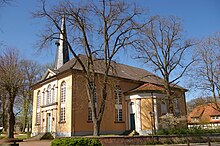
The St. Nikolai Church in Kirchdorf is the center of a parish with six villages: Bahrenborstel , Holzhausen, Kirchdorf, Kuppendorf, Scharringhausen and Woltringhausen . It was built between 1831 and 1833 under consistorial builder Hellner . A classicist church was built on the plan of a cross , the sobriety and simplicity of which indicates the center of the Protestant faith: the word of God. The pulpit is the only piece of furniture that has decorations. The tower dates back to the 14th century and received its slim helmet in 1805. The church is spatially the largest in the church district of Grafschaft Diepholz. It was designed for 1200 people. In 1964 a thorough renovation took place, during which the originally Romanesque font was also restored. The organ was built in 1972 by Emil Hammer Orgelbau . The big bell dates from 1500, the two small bells from 1952 and 1953.
Green spaces, local recreation and others
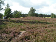
In the southeast of the community there is a large contiguous heather area , the Kuppendorfer Heide , next to Kuppendorfer Straße . The continued existence of the Kuppendorfer Heide is guaranteed by a herd of moorland snakes , which prevents excessive vegetation with trees and bushes. There are several raised bogs on the edge of the community . In 2008, Kirchdorf took 2nd place in the Diepholz district in the “ Our village has a future ” competition.
education
Kirchdorf is the location of a primary school and a branch in Bahrenborstel. All children from the integrated community can attend the Kirchdorf Oberschule or the Sulingen grammar school after completing primary school.
Web links
Individual evidence
- ↑ State Office for Statistics Lower Saxony, LSN-Online regional database, Table 12411: Update of the population, as of December 31, 2019 ( help ).
- ^ Federal Statistical Office (ed.): Historical municipality directory for the Federal Republic of Germany. Name, border and key number changes in municipalities, counties and administrative districts from May 27, 1970 to December 31, 1982 . W. Kohlhammer, Stuttgart / Mainz 1983, ISBN 3-17-003263-1 , p. 189 .
- ^ Jürgen Udolph (research): The "place name researcher". In: website NDR 1 Lower Saxony . Archived from the original on December 2, 2016 ; accessed on March 11, 2019 .


